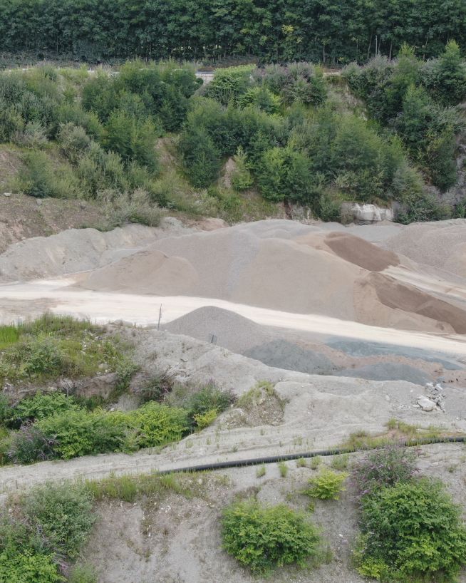
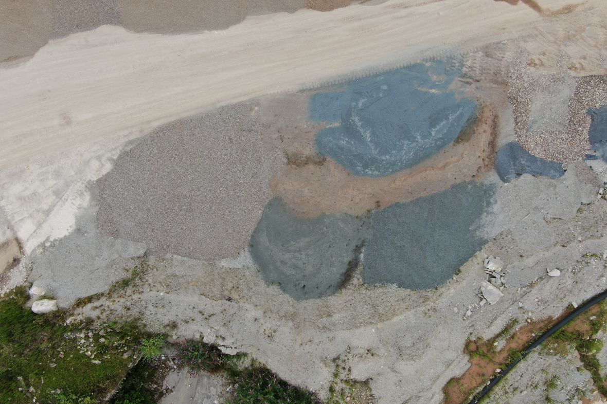
Stockpile volume measurement
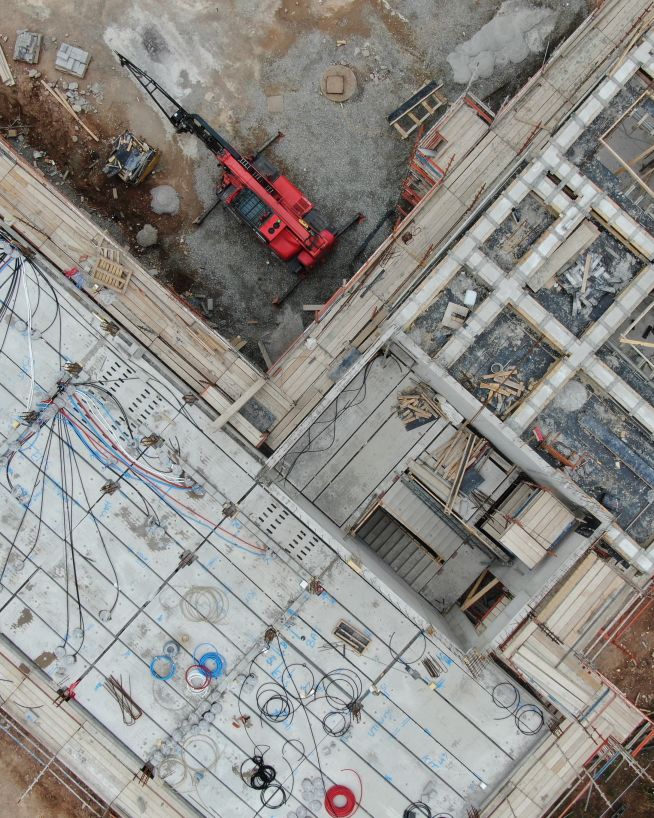
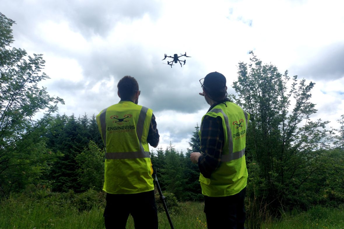
Keep track of inventory using drones. Aggregate measurements are more efficient when work remains uninterrupted.
Keep track of inventory using drones. Aggregate measurements are more efficient when work remains uninterrupted.
Accurate stockpile volume measurements can be essential in keeping construction on budget. However, typical methods require lots of tools and manpower. Using drones, we can calculate your stockpile volume in one easy flight. Leaving work below uninterrupted.
Calculate the weight of your stockpile, faster and more cost-efficiently than using traditional methods.
Get quick and precise readings on cut-and-fill measurements, allowing for seamless tracking and future ordering.
Record and compare your volume measurements over time, more cost-efficiently and with fewer man-hours.
Easily streamline your supply chain logistics with high-definition and ultra-manageable reporting.
Find all anomalies and potential problems that might otherwise go undetected.
The applications of stockpile volume measurement in domestic and industrial environments are almost limitless. Ask us what it can do for you.
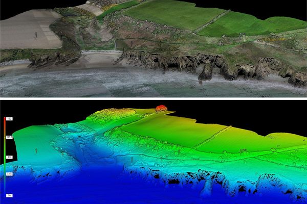
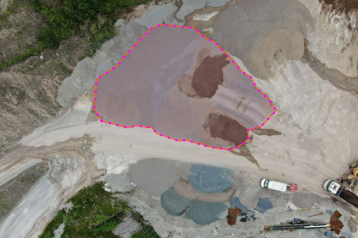
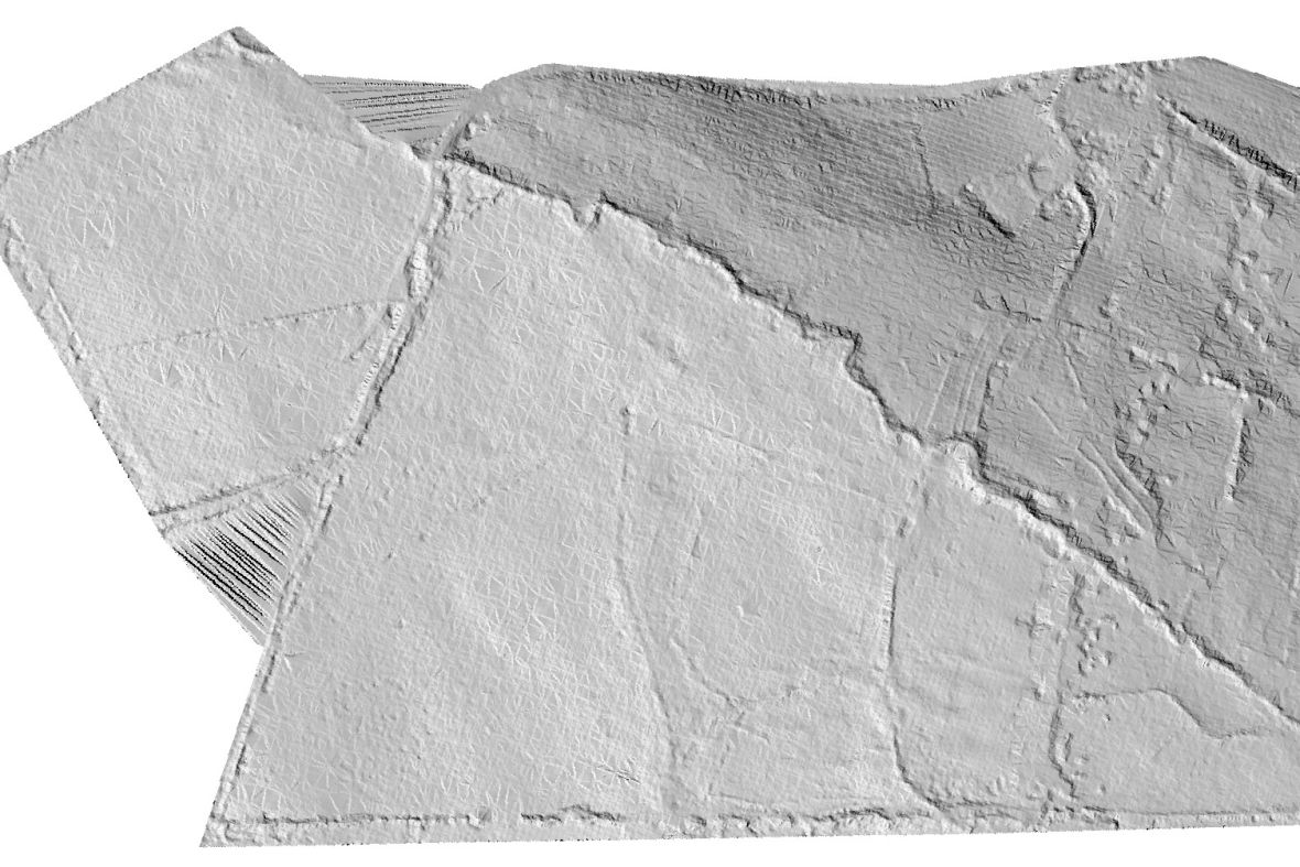
A drone volume survey works by capturing the complete three-dimensional surface of a stockpile — millions of points across every slope, ridge, and toe — and then comparing that surface against a reference plane or a previous survey. The volume is the space between the two surfaces. This is fundamentally different from a ground survey, which captures a few hundred points and interpolates the rest.
What is the difference between a DSM and a DTM, and why does it matter for stockpile measurement?
A digital surface model (DSM) includes everything on the ground — stockpiles, trees, buildings, vehicles. A digital terrain model (DTM) represents the bare earth with all surface features removed. The two models are generated from the same LiDAR point cloud: the DSM is the first return (what the laser hits first), and the DTM is produced by classifying and filtering out non-ground points.
For stockpile volume measurement, the calculation is a subtraction: DSM minus DTM over the stockpile footprint equals the pile volume. If you measure from a DSM that includes the pile against a DTM that shows the bare yard underneath, the difference is the volume of material sitting on the ground. Do this across every stockpile on site in a single flight, and you have a complete inventory statement.
More about 3D mapping and surface modelsWhat does an elevation heatmap tell me that a photograph of the stockpile does not?
A photograph of a stockpile can be misleading. Shadows, material colour variations, and the angle of the sun can hide the true shape of the pile. An elevation heatmap replaces colour with absolute height data — every pixel has a known Z-value — so the crest, the toe, and every bench and slope angle are unambiguous.
For stockpile management, this is particularly useful for verifying that material is being stacked within the safe angle of repose, identifying sections of a pile that have been drawn down between surveys, and confirming that aggregate grades are separated and stored in the correct bays. The heatmap turns a pile into a measurable inventory item.
Discuss stockpile volume measurement for your site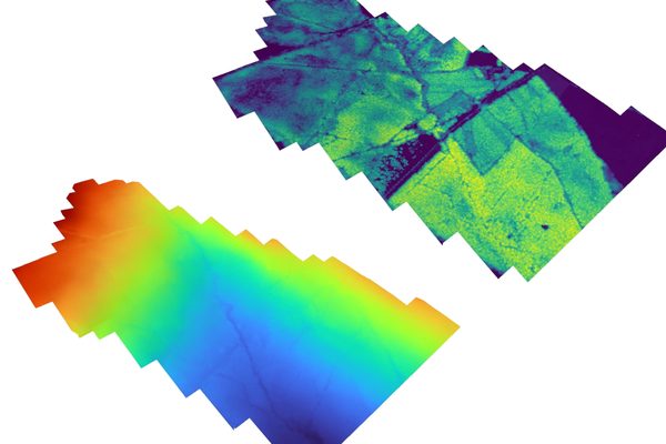
As drone stockpile calculations can be done so easily, they can also be done more frequently. This is a cost-effective way of keeping track of a site's materials and aggregate. Frequent flights allow for more accurate time and budget allocation, streamlining the entire construction process.
Keeping all your inventory on track is invaluable when making estimations. Know ahead of time when supplies are running low - allowing you to keep your timeline on track, with no delays.
We use the latest 3D modelling software to automatically calculate volume and area. Our drone is equipped with a high-resolution camera, ensuring that your deliverables are precise and high-quality.
Traditionally, keeping a record of progress was a time-consuming and laborious task. With our stockpile volume measurement, you can keep a record of your project's status at any stage you decide.
With our stockpile volume measurement, you can share crystal clear points of interest with your whole team. Instantly display individual sections of your assets, or zoom in for pinpoint analysis.
By choosing stockpile volume measurement via a drone, you can set your stakeholders' minds at ease with the knowledge that it is being monitored by the best technology currently available.
By creating stockpile measurements using a drone, there is no need to halt or reduce any on-site operations. You and your team are then free to inspect the results, again, without having to interrupt any other day-to-day tasks.
We use cutting-edge technologies to detect problems that would otherwise be invisible. These include 4K ultra-HD photography/video, LIDAR and thermal imaging.
Drones aren't just for flying up in the sky. Our specialist drones can fly into confined spaces like chimneys and boilers to look for issues that would otherwise be inaccessible.
Downtime is expensive and inconvenient. Using a drone, our engineers can conduct a thorough survey with little to no downtime.
Our equipment won't touch or even go close to your assets. Our high-resolution cameras use optical zoom to give extreme close-up views while staying a safe distance away.
We understand that you need answers fast. We can deliver a plain-English report with clear-cut conclusions in days. Then, you can take the steps you need to and get back to doing what you do best.
Need us there in a hurry? No problem. Let us know what you need, and we can be there on the same day. After all, sometimes the problem just won't wait.
Sometimes the brief can change even in real-time. If need be, you can be stood there right next to the drone operator, directing them as the situation develops.
The safety of your personnel and our own is paramount, and we place it at the forefront of our company culture. Ask us about our HSSE systems and practices.
Stockpile volume measurement is incredibly versatile, and we use it in various types of inspections serving multiple industries.


Engineers With Drones is the first company in Ireland to hold the new EASA Specific Category authorisation. We are authorised by the Irish Aviation Authority (IAA) and the European Union Aviation Safety Agency (EASA) for commercial Unmanned Aerial Vehicle (UAV) operations in both urban and rural environments. Total transparency: our Specific Category Authorisation Number is IRL.UAS.AUTH1002.
All of our operations are insured in the EU and globally. We hold €6.5m public and product liability, €13m employer's liability and €1.3m professional indemnity (base level, coverage raised as required).
We are more than just drone pilots. If you're looking for overhead footage of your wedding reception, we're probably not right for you. Our backgrounds and our primary qualifications are in engineering, and it's here that we think we add the most value. We know what we're looking for, and we know how to find it. If you have a technical engineering problem that a drone can solve, we can understand you. Tell us what you need to see or find out, and our engineers will use their drone piloting skills to make it happen.
Yes. We're a local Irish company, and that's how we can respond so quickly to the needs of our Irish clients. We can be with you in next to no time, with the right equipment and certifications to operate them, whatever your location.
Optical zoom is a feature found in cameras that allows you to change the focal-length of the lens, which in turn magnifies the image. Unlike digital zoom, which simply enlarges the pixels of an image, optical zoom physically moves the lens elements to zoom in or out, resulting in a higher-quality, more detailed image.
Optical zoom is better than digital zoom for several reasons. Firstly, optical zoom maintains the image quality and sharpness because it captures more detail from the subject. In contrast, digital zoom often results in a pixelated, blurry image because it enlarges the existing pixels of an image, which degrades the quality.
Secondly, optical zoom allows you to get closer to your subject without physically moving closer, which can be useful in situations where you cannot or do not want to approach your subject closely. This can be especially helpful for wildlife photography or for taking photos of events from a distance.
Overall, optical zoom is a valuable feature that can help you capture high-quality, detailed images from a distance, making it a must-have for many photographers.

UHD or Ultra High Definition signifies that a camera's resolution is 3840x2160 pixels. This is exactly four time higher than high definition cameras (1920x1080 pixels), and so UHD is often also know as 4K.