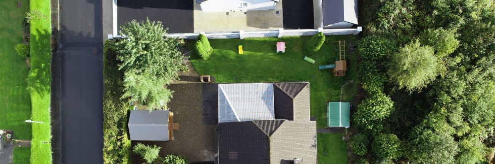
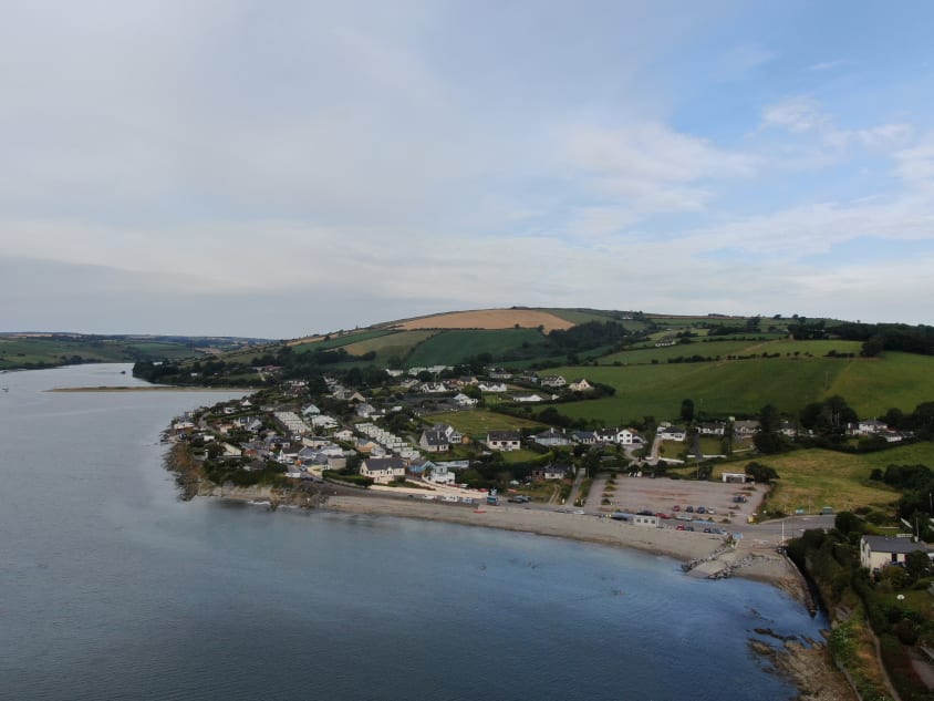
The vast majority of property purchases today take place online. There has never been a better time to stay ahead of the curve. Traditional methods used to capture aerial footage, i.e. helicopters and planes, are expensive, time-consuming and offer limited visibility. Using drones allows you to view, record and showcase your property from unique angles. Drone footage enhances the appeal of your property listings and wows potential buyers. Engineers With Drones will capture stunning aerial photography and birds-eye video footage. Helping to highlight your property's proximity to its nearby amenities, roads, and neighbourhood. And this at a fraction of the cost of traditional methods.
More and more people in real estate are turning to drone services to demonstrate the scale and size of the interior as well as exterior of a property. Engineers With Drones will not only make your property listing shine, we will also ensure that you can showcase your property with confidence to potential buyers, sellers, colleagues and other stakeholders.
Our stunning high-definition aerial photography and video footage will help to:
With a traditional ground-based photo shoot of a property, potential buyers are asked to fill in the dots of the surrounding landscape. Adding aerial images allows someone to get a feel for the lay of the land and the property’s relationship to it. We provide high-definition photos and videos of:
Engineers With Drones offer a fast, professional and cost-effective package for all your business needs. Helping you to put your best foot forward when showcasing your property. Contact us today and we can talk you through the process.
Drones are not just a marketing tool. They can be useful for real estate companies in other ways as well: to survey land, inspect roofs & buildings, property and land valuations, assess damage and more...
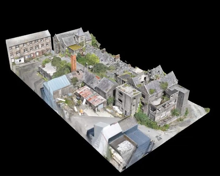
Engineers With Drones used external 3D scanning and internal confined space drones to survey a derelict hospital building in Wexford for restoration feasibility, without placing any personnel at risk.
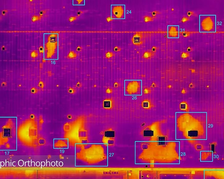
Engineers With Drones combined drone technology, thermography and orthophotos to locate water ingress across 5.2 hectares of flat bitumen roof on a large commercial building.
Complex surveys and inspections require more than just a pilot. Our engineers can help you scope your requirements and indentify the right approach.
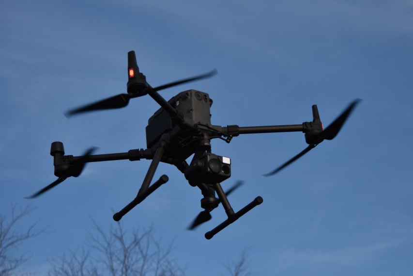
Here at Engineers With Drones, we fly the latest cutting-edge drones. Our UAVs are selected specifically for the tasks they perform. Drones such as the DJI M300 and payloads such as the Zenmuse H20T with high optical zoom lenses are optimal for safely inspecting high-value assets at a stand-off range.
To find out more about our drone equipment and what it can do click here.
Contact us today to see what we can do for you...


Optical zoom is a feature found in cameras that allows you to change the focal-length of the lens, which in turn magnifies the image. Unlike digital zoom, which simply enlarges the pixels of an image, optical zoom physically moves the lens elements to zoom in or out, resulting in a higher-quality, more detailed image.
Optical zoom is better than digital zoom for several reasons. Firstly, optical zoom maintains the image quality and sharpness because it captures more detail from the subject. In contrast, digital zoom often results in a pixelated, blurry image because it enlarges the existing pixels of an image, which degrades the quality.
Secondly, optical zoom allows you to get closer to your subject without physically moving closer, which can be useful in situations where you cannot or do not want to approach your subject closely. This can be especially helpful for wildlife photography or for taking photos of events from a distance.
Overall, optical zoom is a valuable feature that can help you capture high-quality, detailed images from a distance, making it a must-have for many photographers.
