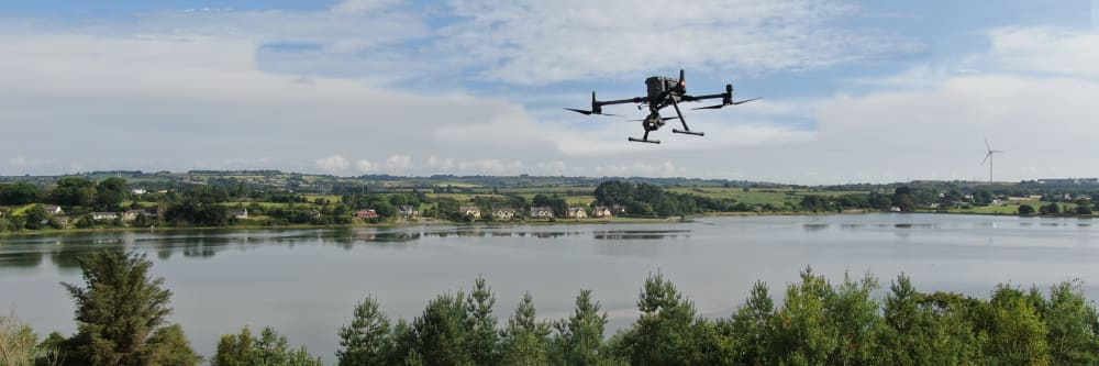
River banks and flood defences can extend for many kilometres. A drone survey can cover long stretches rapidly from the air, capturing bank condition, erosion, vegetation encroachment, and flood defence integrity in a single deployment — with no boots on the bank, no boats in the water, and no impact on the environment.
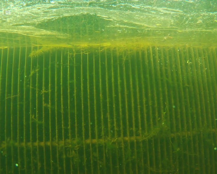
Where structures extend below the waterline, an underwater ROV can inspect submerged surfaces without the need for divers — weir gates, lock walls, sluice faces, and culvert inlets can all be assessed while the waterway remains in service.
What can a drone detect on a waterway?
From the air: bank erosion, undercutting, slope failure, flood defence gaps and deformation, invasive vegetation growth, and structural condition of above-water infrastructure such as weir crests, lock gates, and sluice mechanisms.
Below the waterline: submerged structural damage, debris accumulation, scour around foundations, concrete cracking and spalling on weir gates and lock walls, and investigation of anomalies identified by hydrographic survey.
See what an underwater ROV inspection coversHow much waterway can you cover in a single deployment?
Multiple kilometres of riverbank or canal can typically be covered in a single day of aerial survey — far faster than walking or boating the same stretch. The drone follows a pre-planned GPS route, so the same path can be repeated exactly for monitoring surveys over time.
For underwater ROV work, coverage depends on water depth, visibility, and access points. A typical day on the water can cover multiple anomaly locations or structure faces.
Discuss your waterway inspection requirementsDo you need to drain or divert the waterway?
No. Both aerial drone surveys and underwater ROV inspections are carried out while the waterway remains fully in service. No draining, no diversion, and no disruption to water flow or navigation.
The ROV is deployed from a boat at the surface and descends to the structure. It never makes contact with the asset, and the inspection is monitored in real time from the surface.
Discuss your site requirementsWhat is the turnaround time for a waterway inspection?
Aerial survey fieldwork for several kilometres of waterway can typically be completed in a single day. Underwater ROV investigation of multiple structures or anomaly locations usually takes one to two days on the water. The full condition report is typically delivered within a few working days of fieldwork completion.
Every waterway is different, so timelines are confirmed before any work begins.
Discuss your inspection timelineA drone survey can cover kilometres of riverbank or flood defence in a single deployment, capturing erosion, undercutting, slope failure, and vegetation encroachment from the air. Thermal imaging can detect seepage and water infiltration through embankments that is not visible to the naked eye — identifying developing problems before they become structural failures.
Above-water structures — weir crests, lock gates, sluice mechanisms, head race walls — can all be surveyed from a safe standoff distance in the same flight, with no boots on the bank and no boats in the water.
Can you detect seepage through flood defences?
Thermal imaging can detect temperature differences caused by water infiltration through embankments and flood defences. Seeping water cools the surrounding material, creating a thermal signature that is visible to a thermal camera even when no surface evidence of a leak is present.
All EWD drone operators are trained thermographers, meaning thermal data is captured and interpreted by qualified personnel.
More about our thermal imaging servicesCan you repeat the same survey path for monitoring?
Yes. The drone follows a pre-planned GPS route, so the exact same flight path can be repeated for subsequent surveys — ensuring that imagery from one inspection is directly comparable to the next. This is particularly valuable for monitoring bank erosion rates and flood defence condition over time.
More about our 3D mapping and monitoring servicesWhat about working at height regulations for weir and lock inspections?
The Safety, Health and Welfare at Work (Work at Height) Regulations 2006 (S.I. No. 318 of 2006) require that work at height be avoided where it is reasonably practicable to do so. A drone survey satisfies this at the first step of the hierarchy of control — weir crests, lock gates, and head race walls are inspected from a safe standoff distance with no one working at height or over water.
Because no one leaves the ground, the duties to provide fall protection, guardrails, or rescue arrangements for work at height do not arise.
More about our regulatory compliance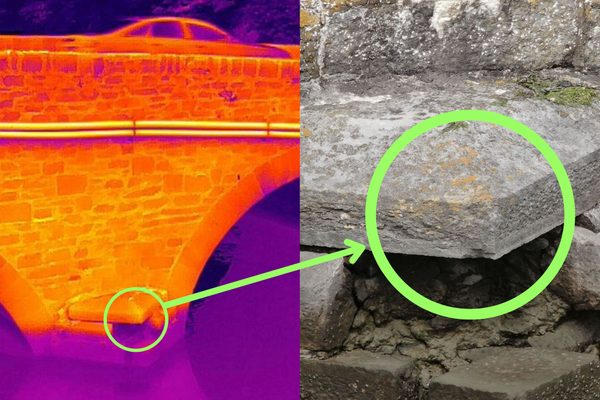
Where structures extend below the waterline, an underwater ROV can inspect weir gate faces, lock walls, sluice inlets, and bridge piers without the need for divers. The ROV is deployed from a boat, generates 4K video with depth and altitude readings visible in the footage, and the client can monitor the live feed alongside the operator, directing the inspection in real time.
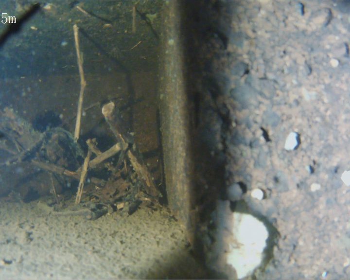
The ROV can also investigate anomalies identified by hydrographic survey — depressions, trenches, unexplained features — at known GPS coordinates, orbiting each target and recording detailed imagery for the engineering team to assess.
What does an ROV investigation of a hydrographic anomaly involve?
The client provides GPS coordinates of anomaly locations from their hydrographic data. EWD deploys the ROV from a boat that navigates to each coordinate. The ROV descends to the anomaly, generates 4K video and still imagery while orbiting and looking inside it, and records depth and altitude throughout.
The client has a live monitoring screen alongside the operator and can direct the pilot in real time — asking for different angles, zooming in on specific features, or adjusting scope on the spot. Imagery is delivered with useful naming so the client can correlate footage to specific anomaly locations.
Discuss your ROV investigation requirementsCan an ROV replace a diver for lock gate and weir inspections?
For pure visual inspection, yes — and with practical advantages. No dive team to arrange, no standby rescue diver, no risk to personnel in confined submerged spaces near sluice gates or intakes, and the ability to operate safely in low-visibility or contaminated water where a diver should not be deployed.
If the inspection reveals a problem that needs hands-on intervention — clearing a blockage, taking a physical sample, making a repair — a diver can then be deployed to the exact location with a clear brief, saving the cost of an exploratory dive.
Discuss the right approach for your structure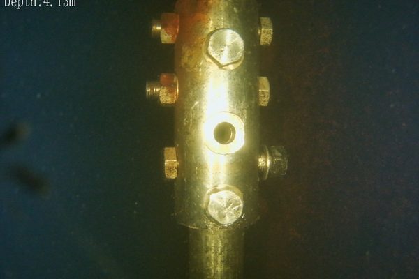
Culverts, sluice chambers, and penstocks are confined spaces by definition — and entry for inspection typically requires dewatering, atmospheric testing, a confined space entry permit, and a standby rescue team. A cage-protected confined space drone or ROV can enter and inspect the full interior without any person entering the space, and typically without dewatering.
What a confined space inspection can detect: blockages, structural cracking, joint separation, debris accumulation, corrosion, and coating failure on internal surfaces. Every defect is recorded on 4K video with still photography for inclusion in the inspection report.
What confined space regulations apply to culvert and sluice inspections in Ireland?
The Safety, Health and Welfare at Work (Confined Spaces) Regulations 2001 (S.I. No. 218 of 2001) require that a person shall not enter a confined space unless it is not reasonably practicable to carry out the work without entry. A confined space drone or ROV inspection satisfies this requirement at the first step — the inspection is completed without any person entering the culvert, sluice chamber, or penstock.
Because no human entry takes place, there is no confined space entry permit to prepare, no atmospheric testing regime to stand up, and no standby rescue team to arrange.
More about our regulatory complianceCan a drone enter a culvert without dewatering it?
Whether a confined space drone or ROV can enter a culvert that is in service depends on the specific site conditions — water level, flow rate, access point position, and internal atmosphere. Every site is assessed individually before any work begins to confirm feasibility. Where conditions allow, an ROV can swim into the culvert without any dewatering or diversion.
The key point: no person enters the culvert. The drone or ROV goes in; the pilot and the inspection team remain outside.
More about confined space drone inspectionsGPS-referenced flight paths enable the exact same survey to be repeated at regular intervals, providing directly comparable records of bank erosion, vegetation spread, and structural change over time. For waterway managers, this turns an inspection from a one-off event into a monitoring programme.
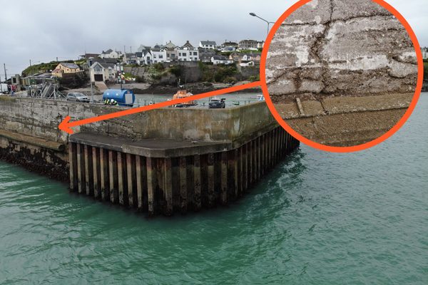
A photogrammetric 3D model can be generated from the same drone imagery, giving you a dimensioned digital twin of weirs, locks, and above-water structures. Measure crack propagation, track spalling spread, and compare year-on-year to quantify change — all without returning to the site.
How does repeatable GPS monitoring work for waterways?
The drone follows a pre-planned GPS route so the exact same flight path is repeated for every survey. Imagery from one inspection is directly comparable to the next — erosion rates can be calculated, vegetation spread measured, and structural deterioration quantified rather than estimated.
For flood defence monitoring, repeatable surveys provide the evidence base needed to prioritise maintenance spend and demonstrate due diligence to insurers and regulators.
More about our 3D mapping and monitoring servicesWhat can a 3D model tell me about my waterway structures?
A photograph shows you a crack. A 3D model tells you exactly how long it is, whether it has grown since the last inspection, and where it sits in relation to other defects. You can measure dimensions directly on the model without specialist software, and stakeholders who have never visited the site can inspect the structure virtually.
The model also becomes a baseline for future inspections. Compare this year’s model against next year’s and every change is quantifiable.
Discuss what a 3D model could reveal about your waterway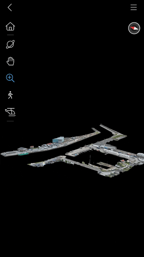
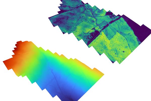
A LiDAR survey captures millions of survey-grade measurements across a waterway corridor in a single flight, producing a topographic model that reveals exactly how the ground shapes the flow of water. For river and flood defence engineers, this is the difference between looking at a photograph of a bank and having a measurable dataset of every slope, depression, and elevation change along it.
What is the difference between a DSM and a DTM for waterway assessment?
A digital surface model (DSM) includes everything on the ground — vegetation on the bank, trees overhanging the channel, structures on the flood plain. A digital terrain model (DTM) represents the bare earth with all surface features removed. Both are generated from the same LiDAR point cloud.
For waterway engineers, the DTM is essential for flood modelling: it shows the true shape of the flood plain without vegetation distorting the cross-sections. The DSM is used to identify vegetation encroachment into the channel and trees that could fall and obstruct flow. Comparing a DSM captured before and after a flood event reveals exactly where bank material has been scoured away, giving a measurable erosion volume rather than a visual estimate.
More about LiDAR drone surveysWhat does an elevation heatmap tell me that a photograph of the riverbank does not?
A photograph of a riverbank can be misleading. Shadows from trees, reflections off the water, and vegetation cover can hide slope failures, undercutting, and subtle changes in bank profile. An elevation heatmap replaces colour with absolute height data — every pixel has a known Z-value — so bank angles, scour holes, and areas of active erosion are unambiguous.
For flood defence assessment, this is particularly useful for identifying low points in an embankment where overtopping would occur first, mapping the natural flood plain extent, and tracking bank migration between survey dates to quantify erosion rates. The heatmap turns a walkover survey into a measurable engineering dataset.
Discuss elevation mapping for your waterway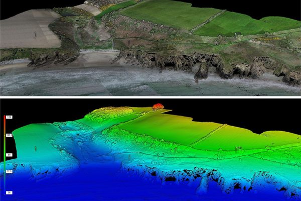
A single aerial deployment can survey multiple kilometres of riverbank, canal, or flood defence — far faster than walking or boating the same stretch.
Aerial drone for banks and above-water structures; underwater ROV for submerged faces — one provider, one report, no gaps in coverage.
The ROV inspects submerged structures and culvert interiors without any person entering the water or the confined space.
Thermal imaging can detect water infiltration through embankments and flood defences before surface evidence of a leak appears.
The same flight path can be repeated exactly for monitoring surveys over time — erosion rates, vegetation spread, and structural change tracked precisely.
No boots on the bank, no boats disturbing the waterway, no divers, and no physical contact with the asset or the surrounding habitat.
Walking or boating a waterway for inspection is slow, labour-intensive, and can disturb the environment. A drone survey can cover multiple kilometres of riverbank, canal towpath, or flood defence in a single day — capturing high-resolution imagery of bank condition, erosion, vegetation encroachment, and structural integrity from a consistent aerial perspective. The same GPS-referenced flight path can be repeated for monitoring surveys, providing directly comparable records over time.
Where structures extend below the waterline, an underwater ROV provides the same level of inspection detail that the aerial drone delivers above the surface. Weir gate faces, lock walls, sluice inlets, and culvert interiors can all be inspected without divers and without dewatering. The ROV generates 4K video with depth and altitude readings visible in the footage, and the client can monitor the live feed alongside the operator, directing the inspection in real time.
Tell us what you need to know, and we will work with you to design actionable deliverables that give you the outcomes you need.
A typical waterway inspection delivers an aerial photographic survey of banks and above-water structures, underwater ROV footage of submerged assets, and an annotated condition report that brings both datasets together in a single document. A photogrammetric 3D model can also be generated from the same drone imagery, giving you a dimensioned digital twin of weirs, locks, and above-water structures that can be measured, sectioned, and compared against future inspections to track change over time.
Where a hydrographic survey has identified anomalies, each target is investigated by ROV and the resulting imagery is delivered with naming that correlates directly to the original survey coordinates — so your engineering team can close out each finding with confidence.
High-resolution imagery of banks, flood defences, and above-water structures along the full inspection length.
4K video and still imagery of submerged structures with depth and altitude readings visible in the footage.
Thermal imagery identifying water infiltration through embankments and defences, where applicable.
A dimensioned photogrammetric model generated from the same drone flight. Measure, section, and compare year-on-year to track every change.
All findings compiled into a single document with GPS-referenced defect locations and severity ratings.
Engineers With Drones carried out an ongoing underwater ROV inspection programme across most of the ESB's hydroelectric sites — inspecting inlet screens, turbines, spiral casings, gates, and sealing surfaces without divers or dewatering.
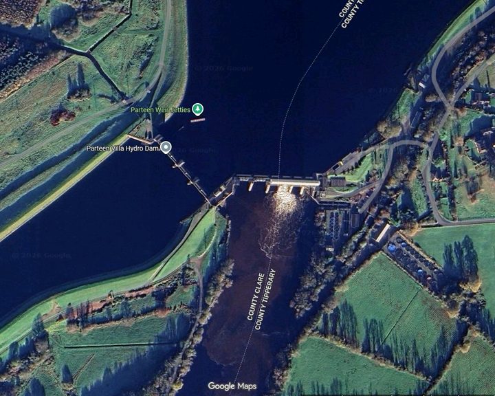
Engineers With Drones used an ROV underwater drone to inspect anomalies in the Ardnacrusha head race canal identified by hydrological survey - historic infrastructure built in the 1920s.
Engineers With Drones deployed an underwater ROV to inspect a live riveted steel penstock, expansion joint, inlet screens, and spiral casing without drain-down or diver entry.
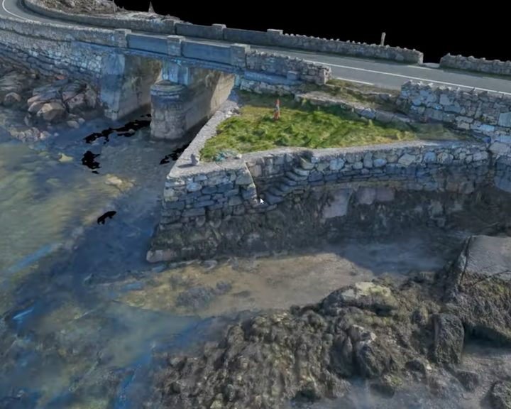
Engineers With Drones surveyed four historic stone causeways in west Galway using photogrammetry to create high-resolution 3D models and technical deliverables.
Complex surveys and inspections require more than just a pilot. Our engineers can help you scope your requirements and indentify the right approach.


