Track possessions are expensive, complex to plan, and can require months of notice. A drone inspection can be planned to avoid all possession requirements — stations, platforms, rail lines, bridges, and overhead line equipment can all be surveyed from adjacent land or airspace with no track access and no disruption to the train schedule.
For overhead line equipment, thermal imaging adds a capability that visual inspection alone cannot provide — detecting resistive faults, worn contact points, and failing clamps before they cause service interruption.
How does a drone inspect railways without disrupting train services?
The drone operates from adjacent land or airspace, not from the track itself. No track possession is required, no engineer accesses the track, and no train service is interrupted. Flights are planned to avoid all possession requirements — inspections can be carried out while the railway remains fully operational.
Airspace checks are completed before every flight via the IAA AirSpace app. Engineers with Drones holds an EASA Specific Category Operational Authorisation (IRL.UAS.AUTH1002) that permits operations in complex airspace environments.
More about our operational authorisationsWhat can thermal imaging detect on overhead line equipment?
Thermal cameras can identify temperature anomalies in catenary components — worn contact points, failed clamps, resistive connections — before they develop into service-interrupting faults. A temperature differential of a few degrees can indicate a developing problem that is invisible to the naked eye.
All EWD drone operators are trained thermographers, meaning thermal data is captured and interpreted by qualified personnel rather than relying on automated camera settings alone.
More about our thermal imaging servicesWhat rail assets can a drone inspect?
Railway stations (roofing, facades, platforms, structures), platforms (surface condition, edge condition, drainage), rail lines (linear inspection of tracks, sleepers, ballast, drainage infrastructure), rail bridges (parapets, piers, soffits, bearings), and overhead line equipment (catenary systems, registration arms, contact wire, droppers, clamps).
Every asset type is surveyed from a safe standoff distance with no track access required.
See our bridge inspection servicesWhat is the typical turnaround time for a rail inspection?
Kilometres of track or multiple structures can typically be covered in a single day of fieldwork. The full condition report is usually delivered within a few working days of the inspection.
Every site is different, so timelines are confirmed before any work begins based on the specific assets, the scope of the inspection, and the deliverables required.
Discuss your inspection timelineA drone survey can cover station roofing, facades, platform surfaces, edge condition, and drainage infrastructure from a safe standoff distance. No scaffolding, no rope access, and no track closures required — inspections can be scheduled during operational hours without disrupting passenger movement or train services.
Does station inspection disrupt passenger movement?
No. The drone operates from a safe standoff distance, typically from adjacent land or a designated launch area away from passenger routes. Inspections can be carried out while the station remains open and fully operational.
Issues spotted early can be scheduled for repair in advance at times when platform usage is low, avoiding the need for reactive closures.
Discuss your station inspection requirementsIs it safe to fly a drone over a busy railway station?
Safety is the first question on every site, and it is the first question answered. All drone operations in Ireland are regulated by the Irish Aviation Authority under the EASA framework (S.I. No. 24 of 2023). Flying over populated areas — such as a busy railway station — is not permitted under the standard Open category rules. It requires a Specific Category Operational Authorisation, which Engineers with Drones holds (IRL.UAS.AUTH1002) — the first company in Ireland to receive this level of authorisation.
Before any station inspection, a site-specific Risk Assessment and Method Statement is prepared and agreed with the site health and safety officer. The drone operates at a safe standoff distance from passengers and structures, and a designated launch and landing area is established away from passenger routes. Professional-grade drones carry redundancy systems — multiple motors, multiple batteries, and fail-safe return-to-home protocols — and airspace clearance is confirmed via the IAA AirSpace app before every flight. The drone’s flight path is routed to avoid members of the public throughout the inspection, and the designated launch and landing area is positioned away from passenger routes.
More about our operational authorisations More about our regulatory compliance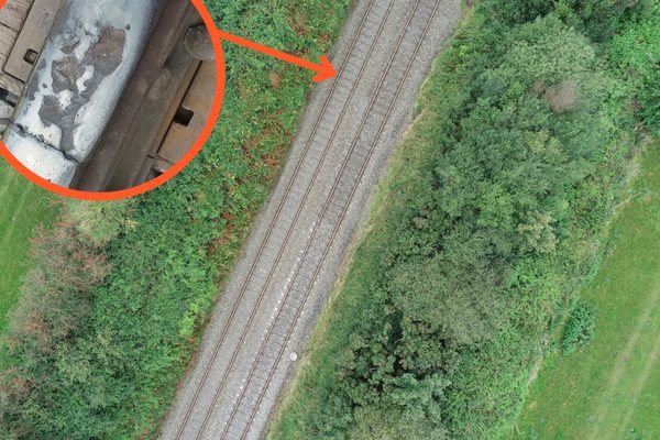
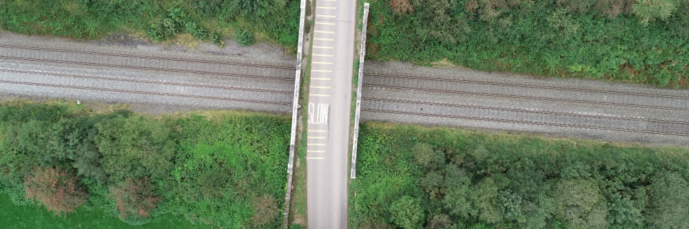
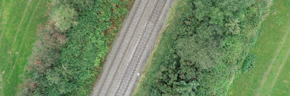
Linear inspection of tracks, sleepers, ballast, and drainage infrastructure can cover multiple kilometres per day. The aerial perspective reveals drainage, surface, and structural issues that are not visible from ground level — and because the drone operates from airspace rather than the track, no possession is required.
What about working near live overhead lines?
The Safety, Health and Welfare at Work (Work at Height) Regulations 2006 (S.I. No. 318 of 2006) require that work at height be avoided where it is reasonably practicable to do so. A drone survey satisfies this requirement at the first step of the hierarchy of control — the inspection is carried out from a safe standoff distance with no personnel working at height or near live conductors.
No one leaves the ground, and no one accesses the track. The duties to provide fall protection, electrical isolation, or rescue arrangements for work at height do not arise.
More about our regulatory compliance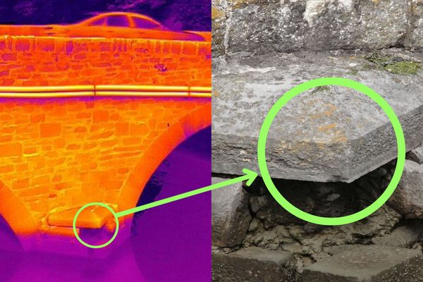
Rail bridges present a particular challenge: the soffit, piers, bearings, and parapets must all be inspected, but track possessions for conventional access are costly and disruptive. A drone survey covers every face of the structure — soffit, piers, abutments, and parapets — in a single deployment, with no track closure and no personnel working at height, over water or near the track. Defects are GPS-tagged and compiled into a chainage-referenced report.
Full bridge inspection services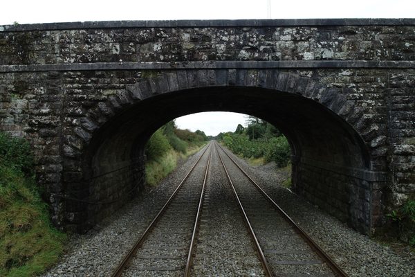
Thermal cameras can identify temperature anomalies in catenary components — contact wire, droppers, clamps, registration arms — before they cause service interruption. A developing resistive fault can produce a temperature differential detectable from the air while still invisible to visual inspection. The drone operates at a safe standoff distance from live OLE, with no electrical isolation required.
Do you need to isolate the overhead lines for a thermal inspection?
No. The drone operates at a safe standoff distance and does not make contact with any part of the overhead line equipment. No electrical isolation, no possession, and no service disruption are required.
A site-specific Risk Assessment and Method Statement is typically prepared and agreed with the site health and safety officer before fieldwork begins.
More about our thermal imaging services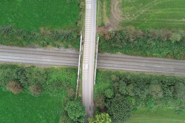
Inspections can be carried out from adjacent land or airspace with no track closures, no complex possession planning, and no months of notice required.
Keeps staff away from live overhead line equipment and moving trains. No engineer accesses the track at any point during the inspection.
Identifies resistive faults, worn contact points, and failing clamps before they cause service interruption — a capability not available through visual inspection alone.
A single deployment can inspect multiple kilometres of track or multiple structures in a day — far faster than conventional walking or vehicle-based methods.
Covers every surface from any angle. The aerial perspective reveals drainage, surface, and structural issues not visible from ground level.
Full condition report typically delivered within a few working days of fieldwork. Defects GPS-tagged and ready to hand directly to your maintenance team.
The overriding constraint on any rail inspection programme is that operations must not be disrupted. Track possessions are expensive, complex to plan, and can require months of notice. A drone inspection avoids all of this: the drone operates from adjacent land or airspace, no engineer accesses the track, and no train service is interrupted. Multiple kilometres of track or multiple structures can typically be covered in a single deployment.
Thermal cameras can identify temperature anomalies in catenary components — worn contact points, failed clamps, and resistive connections — before they develop into service-interrupting faults. A temperature differential of a few degrees can indicate a problem that is invisible to visual inspection. All EWD drone operators are trained thermographers, so thermal data is captured and interpreted by qualified personnel.
Tell us what you need to know, and we will work with you to design actionable deliverables that give you the outcomes you need.
A typical rail inspection delivers high-resolution photography and 4K video of every asset surveyed — stations, platforms, track, bridges, and OLE — with GPS-tagged defect imagery that your maintenance team can act on directly.
Where thermal imaging is included, each identified thermal anomaly is recorded with its GPS coordinates and a corresponding visual-reference image — so your engineering team can locate and assess each finding without returning to the track.
Every asset face photographed in detail — station facades, bridge soffits, platform surfaces, and OLE components.
Full-resolution video coverage of linear assets — track, drainage, and overhead line equipment along the full inspection length.
Each thermal anomaly GPS-tagged with a visual-reference image, ready for your engineering team to assess.
Each defect described, categorised, and located. Structured for direct handover to maintenance and repair teams.
Complex surveys and inspections require more than just a pilot. Our engineers can help you scope your requirements and indentify the right approach.


