Proven Performance

Engineers With Drones Case Studies

Explore real-world engineering project briefs, operational strategies, and high-precision deliverables completed by our UAV survey teams.

Case Study // Aerial Survey Aerial view of rural farmland for solar farm photogrammetric mapping
Large-area mapping
Farmland site in Ireland

Photogrammetry Mapping for Solar Farm Development

Survey-grade photogrammetric mapping of 150 hectares for solar farm site assessment. Complete topographical data, orthophotos, and terrain models for renewable energy development.

Challenge 150-hectare pre-construction survey Deliver survey-grade photogrammetric data across a large, varied farmland site with accuracy sufficient for engineering design software, within a tight timeline and budget.
Technology Drone-based photogrammetry Survey flown at 80m altitude with 80% front and side overlap, capturing 2.2cm GSD orthophoto, DEM, and DSM with custom ground control boards for vegetated terrain.
Case Study // Industrial Inspection View from below looking up inside a 70-metre industrial stack
No production shutdown
Anonymous client (Ireland)

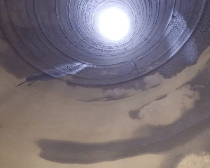
Internal Inspection of a 70-metre Industrial Stack

Confined space drone inspection of a 70-metre riveted steel stack critical to 24/7 production operations — internal inspection without human entry, shutdown, or cooling-down period.

Challenge Critical infrastructure that cannot stop The stack operates 24/7 and any extended shutdown would halt the entire production line. Human entry would require a cooling-down period, confined space permit, and standby rescue team.
Technology Elios 3 confined space drone Caged drone with simultaneous 4K video and LiDAR point cloud capture, navigating the full 70-metre height section by section.
Case Study // Underwater Inspection Underwater ROV inspection inside an ESB hydroelectric dam
Most ESB hydroelectric sites covered
Multiple ESB sites, Ireland

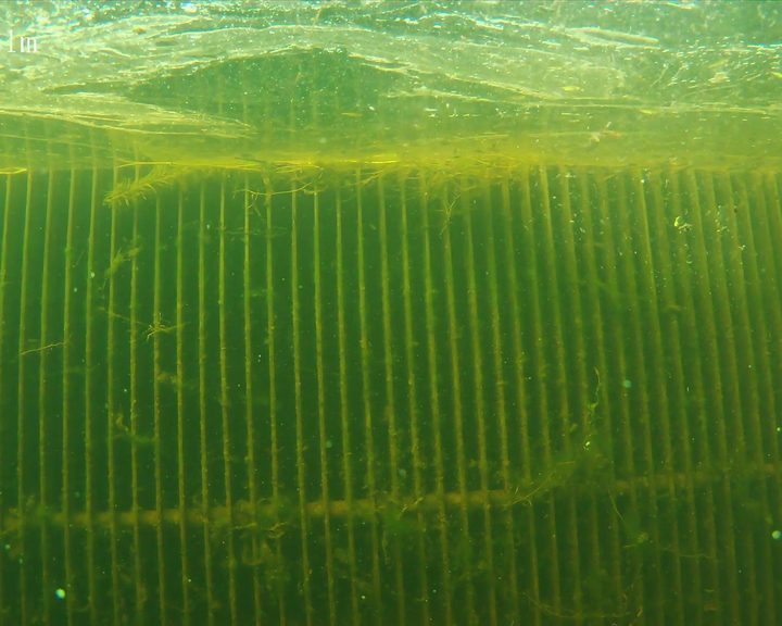
ESB Hydroelectric Dam ROV Inspections

Engineers With Drones carried out an ongoing underwater ROV inspection programme across most of the ESB's hydroelectric sites — inspecting inlet screens, turbines, spiral casings, gates, and sealing surfaces without divers or dewatering.

Assets inspected Critical hydroelectric infrastructure Inlet screens, turbines, spiral casings, gates, sealing surfaces, scour drains, weirs, and valves across multiple generating stations.
Equipment Micro ROV with 4K camera Tethered micro ROV approximately the size of a cereal box, with 4K camera, high-powered lights, and 360-degree thrusters for confined-space navigation.
Case Study // Roof Inspection Aerial view of a commercial shopping estate in Co. Carlow
7 buildings, 1 day on site
Co. Carlow shopping estate

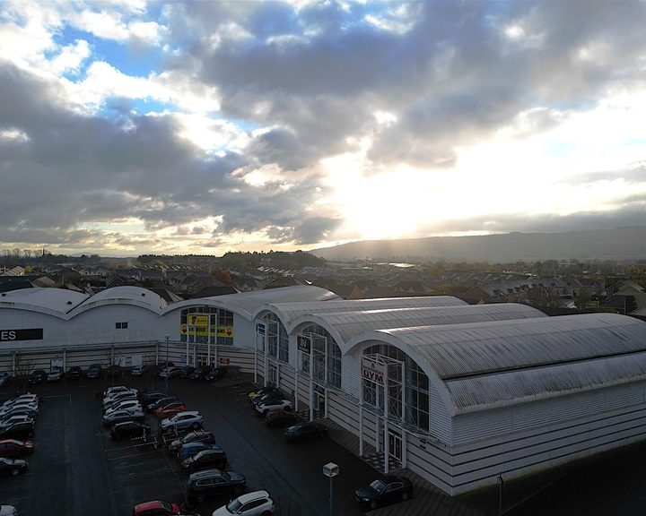
Drone Roof Inspections at a Co. Carlow Shopping Estate

Engineers With Drones inspected seven buildings at a large commercial shopping estate using a sub-250g C0 class drone, completing a full condition survey in a single day while the estate stayed open.

Scope Seven buildings Each with varying roof structures, systematically surveyed with overview and detailed defect imagery captured for every roof.
Equipment Sub-250g C0 class drone Very small, very quiet drone operating legally over people. Inaudible from ground level with zero disruption to shoppers or tenants.
Case Study // Underwater Inspection Underwater ROV inspection inside a hydroelectric penstock at Golden Falls
Zero diver entry required
Golden Falls Hydroelectric Station, Co. Wicklow

ROV Penstock Inspection at Golden Falls

Engineers With Drones deployed an underwater ROV to inspect a live riveted steel penstock, expansion joint, inlet screens, and spiral casing without drain-down or diver entry.

Asset inspected 2-metre diameter penstock Internal condition of a critical hydroelectric water conveyance structure captured in high-definition video.
Inspection scope Four critical zones covered Penstock walls, expansion joint, inlet screens and gate interfaces, and the spiral casing at turbine inlet depth.
Case Study // Heritage Documentation Derelict hospital building 3D model
Zero personnel exposure to structure
Wexford

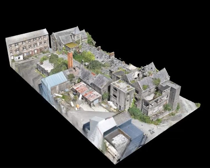
Derelict Hospital Building Survey, Wexford

Engineers With Drones used external 3D scanning and internal confined space drones to survey a derelict hospital building in Wexford for restoration feasibility, without placing any personnel at risk.

Method Two drone systems External photogrammetric drone for 3D scanning, combined with an internal confined space drone for interior documentation.
Challenge Collapsing structure, unsafe to enter Historic hospital building surrounded by perimeter fencing and dense vegetation, deemed structurally unsafe to enter.
Case Study // Thermal Imaging Thermographic orthophoto of a large commercial roof showing water ingress as retained heat
5.2 hectares surveyed
Large commercial building

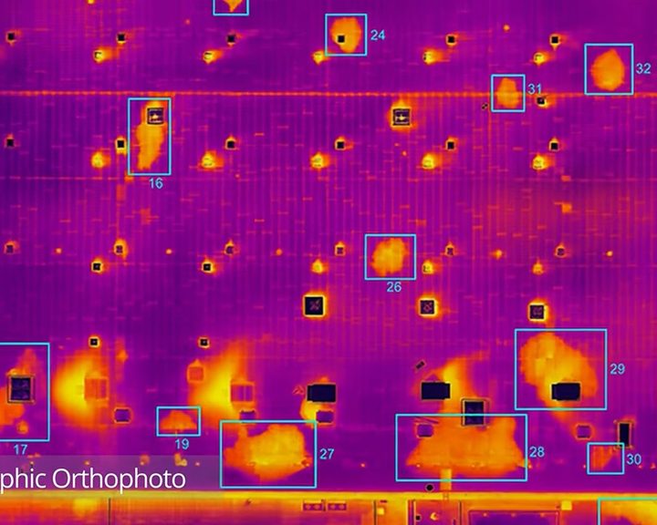
Thermal Drone Roof Inspection of a Large Commercial Building

Engineers With Drones combined drone technology, thermography and orthophotos to locate water ingress across 5.2 hectares of flat bitumen roof on a large commercial building.

Survey area 5.2 hectares Comparable in size to two or three average Irish housing estates - surveyed safely and efficiently from the air.
Data capture Three datasets RGB orthophoto, daytime thermal orthophoto, and nighttime thermal orthophoto - two sessions on the same day.
Case Study // Underwater Inspection Aerial view of Parteen Weir and the head race canal
No unsafe diver entry required
Ardnacrusha head race canal, County Clare

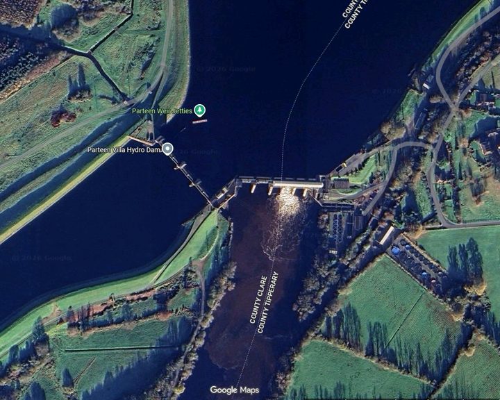
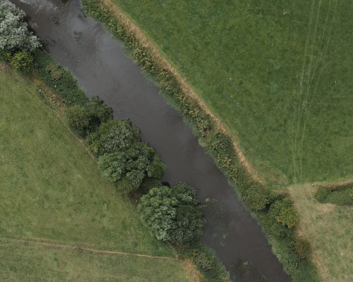
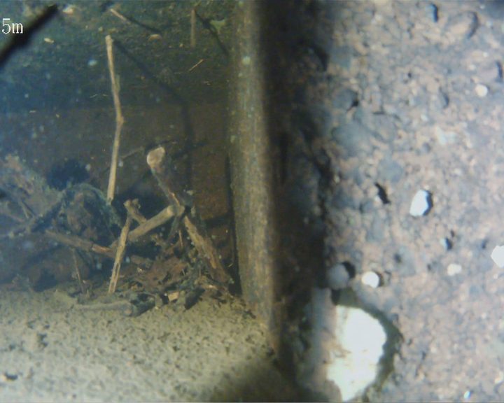
Parteen Weir Underwater ROV Inspection

Engineers With Drones used an ROV underwater drone to inspect anomalies in the Ardnacrusha head race canal identified by hydrological survey - historic infrastructure built in the 1920s.

Technology Freshwater ROV High-resolution underwater imagery captured using a remotely operated vehicle deployed from a boat platform.
Navigation GPS-guided anomaly targeting ROV navigated to predetermined anomaly coordinates identified by prior hydrological survey.
Case Study // Geospatial 3D model of historic causeway in Galway
4 causeways — 1 day each
West Galway

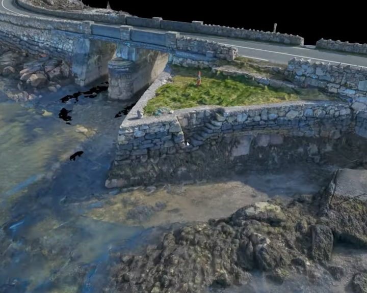
Surveying Historic Causeways in Galway

Engineers With Drones surveyed four historic stone causeways in west Galway using photogrammetry to create high-resolution 3D models and technical deliverables.

Data capture 2,000 – 4,000 images per causeway Each causeway 500 – 1,000m long, serving as a working road and community lifeline in a tidal area.
Processing ~2 weeks per site Full field capture completed in one day per causeway; photogrammetric processing and deliverable production approximately 2 weeks.
Case Study // Industrial Inspection Crane inspection 01
~2 hours on site
Cork

Derelict Port Crane Inspection, Cork

Engineers With Drones used a high-optical-zoom drone to inspect a derelict crane at a Cork port terminal ahead of decommissioning.

Location Jetty end, Cork port terminal Close to water, requiring full PPE including life jackets for all personnel on site.
Key finding Guard rails entirely absent Critical structural components found to be missing. All imagery verified on site before sign-off.
Case Study // Port Infrastructure Belview Port Inspection
Full structure underside captured in 4K
Belview Port, Waterford

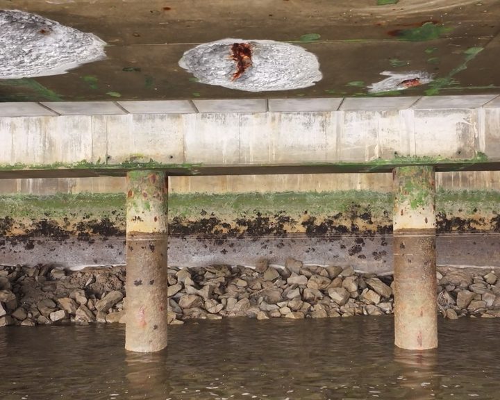
Pier Infrastructure Inspection, Belview Port

Drone inspection of pier infrastructure at Belview Port — examining the underside of shore-side facilities using UAV technology to assess concrete defects and structural integrity safely.

Structure type Shore-side pier on driven piles Access coordinated with port authorities and timed around the shipping schedule.
Constraint Tidal window All fieldwork completed within the tidal window to ensure adequate flight clearance beneath the structure.
Case Study // Geospatial Agricultural land mapping with Drone LiDAR
4,500 hectares across 47 farms
Distributed across Ireland

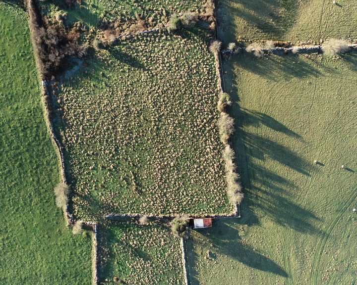
Farm Land Mapping with Drone LiDAR

Engineers With Drones used drone-based LiDAR and multispectral sensors to map large areas of farm land across Ireland, providing detailed information about farms and their carbon sequestration potential.

Scale 4,500 hectares mapped 154 individual plots across 47 farms, some with sub-plots up to 30km from the home farm.
Sensors LiDAR + multispectral Both datasets captured simultaneously in a single flight, reducing site visits and turnaround time.
Case Study // Port Infrastructure Pier Inspection
386 linear metres of pier wall
Coastal harbour, Ireland

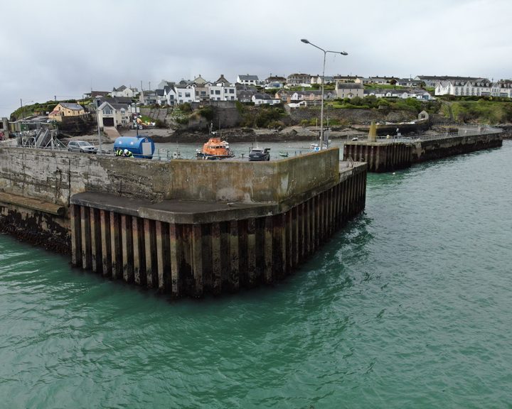
Harbour Pier Wall Drone Inspection

Engineers With Drones carried out a detailed drone inspection of a harbour pier wall, assessing hot-rolled interlocking steel sheet piles and concrete structure for defects and structural integrity.

Structure 386m concrete pier wall Hot-rolled interlocking steel sheet piles and concrete pier requiring detailed defect assessment and classification.
Constraint Two-hour tidal window Full inspection completed within tidal constraints to capture maximum data about the structure below the waterline.
Case Study // Confined Space Water Tank Inspection
Inspection complete in 2 hours
Industrial warehouse, Ireland

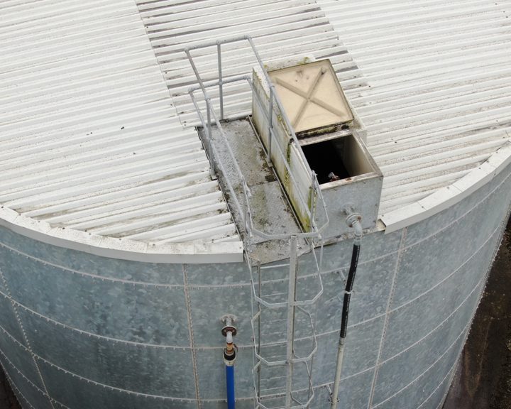
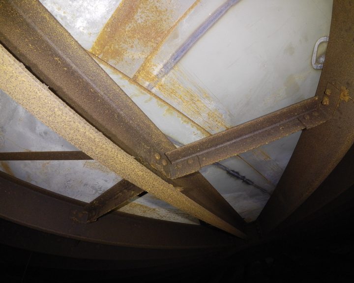
Above-Ground Steel Water Tank Drone Inspection

Engineers With Drones carried out a detailed inspection of a large above-ground galvanised steel water tank used for fire suppression, using a confined space drone to access the interior.

Tank capacity 500,000 litres Galvanised steel tank with corrugated metal roof and multiple penetrations requiring both interior and exterior inspection.
Shutdown time 1 day only Full inspection completed within a single day, minimising disruption to fire suppression system availability.
Case Study // Confined Space Gas Plant Ethanol Tank Inspection
0% personnel entry required
Gas processing plant, Ireland

Confined Space Drone Inspection of a Gas Plant Ethanol Tank

Engineers With Drones used a confined space drone to inspect a large steel ethanol tank on a natural gas processing facility in Ireland — eliminating the need for scaffolding or personnel entry.

Tank specification 13.5m diameter, 10m high Plate steel tank containing ethanol on a facility supplying the Bord Gais gas grid. Access via a 50cm hatch.
Traditional method replaced No scaffolding required Previously required extensive internal scaffolding brought in through the access hatch. Drone eliminated this entirely.
Case Study // Geospatial Coastal Sites Mapping
17 coastal sites across Ireland
17 coastal sites, Ireland

Coastal Sites Mapping for Cable Landfall Assessment

Engineers With Drones surveyed 17 coastal sites across Ireland using drone technology to assess their potential as landfall sites for offshore cables.

Accuracy +/- 50mm hard details Feature vectorisation and CAD drafting achieved minimum tolerance of +/- 50mm for hard details, +/- 100mm for soft.
Deliverables CAD survey drawings Site surveys, orthomosaics, and CAD drawings produced for each of the 17 candidate sites.
Case Study // Structural Inspection Living Bridge Inspection
350m bridge, 6 cable-truss spans
University of Limerick

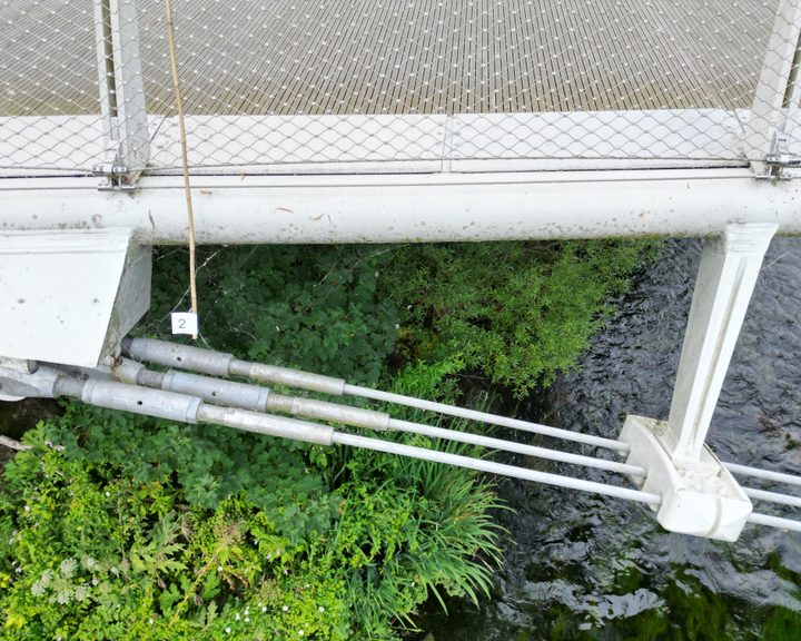
Living Bridge Drone Inspection, Limerick

Drone bridge inspection case study — using a drone to conduct a detailed inspection of a 350-metre pedestrian bridge with an intricate cable-truss design that makes thorough manual inspection difficult.

Structure 350m cable-truss footbridge Six cable-truss spans supported by under-slung catenary cables with tetrapod piers between each span.
Challenge Complex intricate geometry Bridge constructed in 2007 and regularly inspected, but the design makes thorough access very difficult by conventional means.
Case Study // Industrial Inspection Pharma Pipe Rack Inspection
No climbers or MEWPs required
Pharmaceutical manufacturing plant, Ireland

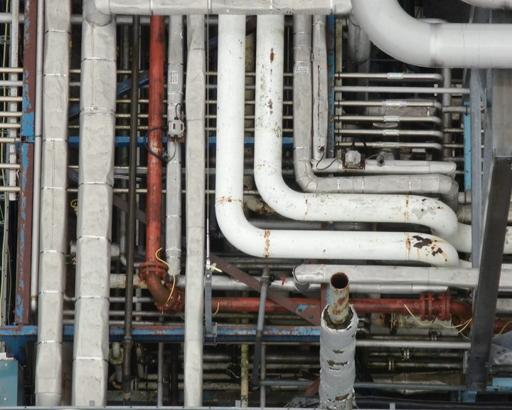
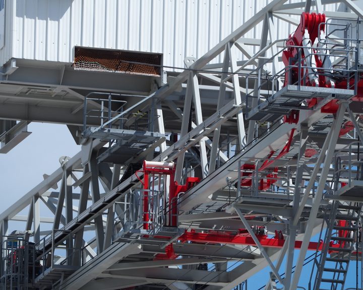
Pharma Plant Pipe Rack Drone Inspection

Engineers With Drones used a drone to carry out a detailed inspection of pharmaceutical plant pipe racks, providing complete coverage of upper surfaces without the need for climbers or mobile elevating work platforms.

Challenge Upper pipe rack surfaces MEWPs could only access a limited number of pipes. Drone provided complete coverage without pipe damage or climbing risk.
Technology Thermal imaging payload DJI M300 with H20T thermographic camera allowing detection of hot gas leaks while maintaining a safe standoff distance.
Overview

About our case studies

The above are case study articles of client work we performed - from project requirements, to how we approached it - and what we found. Some are inspections of structures where getting close safely was the main challenge. Others are survey projects where covering a large area quickly was the priority. We also feature underwater inspection case studies, where the drone was used to get an accurate view of the asset - without any need of divers.

If you are trying to figure out whether drone technology is the right fit for something you have in mind, we hope these help. You can learn about the challenges and deliverables for each type of drone survey or inspection. If you have any questions about the case studies or want to discuss a project of your own, please get in touch.