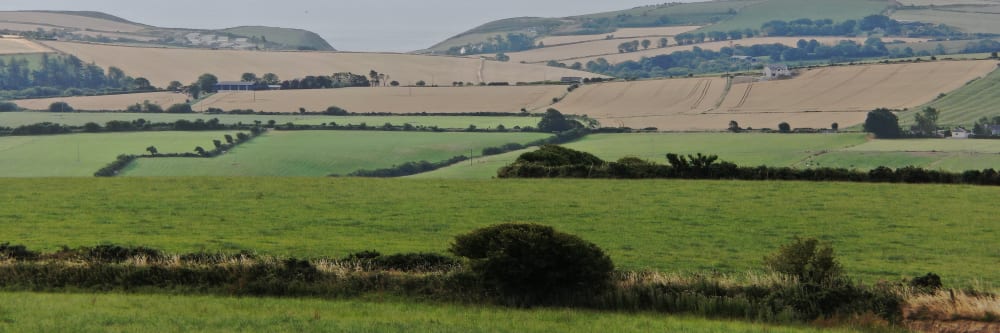
Forestry is an important sector in Ireland, with over 11% of the country covered in forests. However, managing these forests can be a complex task, and it requires accurate and up-to-date information to make informed decisions. That's where Engineers with Drones comes in. Our drone forestry mapping services provide a fast, efficient, and cost-effective solution to gather the data required for forestry management.
Our drones are equipped with the latest technology, including high-resolution multispectral cameras, LiDAR sensors, and precision RTK GPS. This allows us to gather a wide range of data, including 3D maps, tree heights, tree counts, tree species and canopy cover. This data can be used for a variety of purposes, including monitoring forest health, identifying areas of high-risk, and creating detailed forestry management plans.


The safety of your personnel and our own is paramount, and we place it at the forefront of our company culture. Ask us about our HSSE systems and practices.
Drone inspections take up less of your manhours and resources than traditional inspections, giving you a faster and more budget-friendly return on your investment.
We use cutting-edge technologies to detect problems that would otherwise be invisible. These include 4K ultra-HD photography/video, LIDAR and thermal imaging.
Drones capture high-quality, impartial information that gives you an exact assessment of the status and needs of your asset.
Thermal IR technology and ultra HD allow our engineers to get a view that is not available to the naked eye. From a safe distance, we can find defects and insights that are only visible with a drone.
We understand that you need answers fast. We can deliver a plain-English report with clear-cut conclusions in days. Then, you can take the steps you need to and get back to doing what you do best.
Need us there in a hurry? No problem. Let us know what you need, and we can be there on the same day. After all, sometimes the problem just won't wait.
Sometimes the brief can change even in real-time. If need be, you can be stood there right next to the drone operator, directing them as the situation develops.
We help to facilitate forest planning. It's important to get an overview of the land first, as long-term crops need access for years after planting. Efficient land use can facilitate access at all stages of a forest's lifecycle.
Dense forests cause visibility issues. Aerial views of forests provide a better perspective and a clearer view of the area. Planning access roads and walkways is easy when you no longer have to physically navigate the area.
Aerial images of trees show differences in health and density. Problems that aren't visible from a human perspective become apparent when you're above the tree line. After storms and damaging events, drone photography reveals damage that can be quickly repaired.
Multispectral imaging gives insights into the health of individual trees and the forest as a whole. By finding areas that need fertilising, you can focus your efforts where they're needed.
Drones detect disease and pests earlier than the human eye. They can intervene before the problem is so bad that it becomes visible, saving trees at risk of failing.
Using drone LiDAR technology for mapping and analysing forestry is an innovative and efficient approach. LiDAR sensors on drones can capture precise and detailed data of the forest canopy and terrain, which is essential for forest management and planning. The LiDAR data can provide insights into the forest's height, density, and structure, allowing forestry professionals to assess the forest's health and identify areas that require attention.
Moreover, drone LiDAR can facilitate the identification of areas that have suffered from deforestation or other disturbances, enabling efficient restoration and conservation efforts. The use of drone LiDAR technology for forestry mapping and analysis can provide accurate and valuable information to decision-makers, resulting in better-informed decisions and more effective forest management. Here are some common applications of drone LiDAR in forestry:
Drone LiDAR can be used to rapidly and accurately inventory forests, providing detailed information on tree height, canopy density, and tree structure. This information can be used to assess forest health, monitor changes over time, and plan for sustainable forestry practices.
One of the primary benefits of drone LiDAR in forestry is its ability to accurately measure tree height, even in dense forested areas. This information can be used to estimate biomass, predict timber volume, and assess the potential for wind damage or other hazards.
Drone LiDAR can generate detailed maps of canopy density, which can be used to identify areas of high tree cover or areas where thinning or other forestry practices may be necessary.
Drone LiDAR can be used to identify areas of forest that may be experiencing stress or disease, by detecting changes in tree height or canopy density. This information can be used to develop targeted intervention strategies and manage forest health.
Drone LiDAR can be used to estimate carbon sequestration potential in forests, by measuring tree height, canopy density, and biomass. This information can be used to support carbon credit trading and other conservation initiatives.
Drone multispectral cameras are revolutionizing the way we map and analyze forestry. By using sensors that can detect light beyond the visible spectrum, these cameras capture detailed information about the health and growth of trees, allowing us to better understand and manage forest ecosystems.
Multispectral imaging can identify different types of vegetation, as well as areas of stress or damage caused by pests, diseases, or environmental factors. This information can be used to create high-resolution maps, monitor changes over time, and make informed decisions about forest management practices. With the ability to cover large areas quickly and safely, drones equipped with multispectral cameras are a valuable tool for forestry professionals seeking to optimise the health and productivity of our forests. Drone multispectral imagery can be used in forestry for a variety of purposes, including:
Drone multispectral imagery can be used to create high-resolution maps of forests that provide information on tree height, crown diameter, stem density, and species composition. This information can help forestry managers make better decisions about forest management and planning.
Multispectral imagery can be used to detect early signs of forest pests and diseases, such as bark beetles or fungi. This can help prevent the spread of these problems, and enable targeted treatment before a large scale damage occurs.
Multispectral imagery can be used to assess the overall health of a forest by providing data on the health of individual trees, such as their chlorophyll content or leaf area. By analyzing this data, forestry managers can identify areas of the forest that may need attention, such as those experiencing stress due to drought or other environmental factors.
Drone multispectral imagery can be used to estimate the volume of timber in a forest, which is important for planning and monitoring harvests. This can help forestry managers make better decisions about when and where to harvest, and ensure that the forest remains healthy and sustainable.
Complex surveys and inspections require more than just a pilot. Our engineers can help you scope your requirements and indentify the right approach.
UHD or Ultra High Definition signifies that a camera's resolution is 3840x2160 pixels. This is exactly four time higher than high definition cameras (1920x1080 pixels), and so UHD is often also know as 4K.