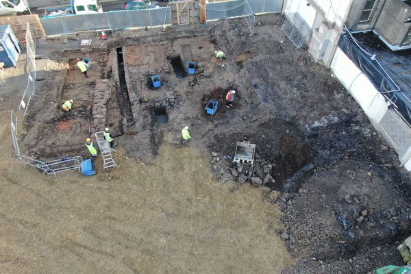
Where the condition of an asset at a specific point in time is disputed, or where the extent of damage needs to be quantified rather than estimated, drone evidence gives claims teams something they can rely on.
Insurance professionals — loss assessors and claims managers — are not primarily buying drone technology. They are buying evidence that is professionally defensible. Every frame we capture is GPS-referenced to a precise coordinate and automatically timestamped at the moment of capture. That provenance is built in and cannot be edited after the fact. The inspection is carried out by an independent, commercially certified operator — not employed by the insured or the contractor. Coverage is systematic: the full asset, not a selection of angles.
Every frame is geotagged to a precise coordinate and automatically timestamped at the moment of capture — not added afterwards. Confirmed capture location and confirmed capture time are the two properties that make drone imagery professionally defensible in a claims context. No other capture method provides both by default.
Our inspection is carried out by a commercially certified operator who has no relationship with the insured party or the contractor. Systematic full-asset coverage — not selected angles — means the output cannot be accused of cherry-picking. For claims where objectivity matters, the independence of the evidence source is as important as its content.
Where a claim rests on a quantity — tonnes of aggregate, grain, or silage lost in a fire or flood; timber or coal in a yard; bulk material in damaged storage — the insured's own figure is the starting point for a dispute, not a settlement. Drone volume measurement produces an independently calculated figure from survey data. What remains after a loss event is measured, not estimated. For large damaged areas, the same approach gives a calculated extent rather than an approximated one.
The same flight profile can be re-flown to produce directly comparable datasets at different points in time. For ongoing or disputed claims where the condition of an asset is tracked across weeks or months, repeat surveys under consistent conditions give claims teams a reliable change record.
Every image is geotagged to a confirmed coordinate. Provenance of capture location is built into the file — not added after the fact.
Captured time is recorded at the moment of capture and cannot be edited. Confirmed time of capture is critical for disputed-condition claims.
Inspection carried out by an operator with no relationship to the insured or contractor — objective, systematic, and professionally credentialed.
The full asset is surveyed, not a selection of angles. No cherry-picking. Consistent flight profiles mean coverage can be independently verified.
The same flight profile can be re-flown at any time. Directly comparable datasets at different dates give claims teams a reliable change record.
Where a claim turns on how much material was lost — aggregate, grain, silage, timber — the insured's own figure is not a settlement. A drone survey calculates what remains from independent survey data.
GPS-referenced drone imagery has two properties that make it useful in a claims context: confirmed capture location and confirmed time of capture. Both are automatic and both are built into the file at the moment of capture — they cannot be altered retroactively. Produced by an independent, commercially certified operator, with systematic coverage of the full asset rather than selected shots, the dataset carries a level of evidentiary weight that phone photography or contractor-supplied imagery does not.
For claims professionals who need to pass evidence up the chain — to a director, an underwriter, or a legal team — that provenance is what makes the output usable as more than a visual reference.
Agricultural claims — crop and building damage from storm, flood, or fire. Industrial claims — damage to plant, equipment, and storage from fire, flood, or impact. Infrastructure claims — storm or flood damage to roads, bridges, and coastal assets. Construction claims — on-site incidents and defect investigations. Stockpile and bulk storage claims — volume discrepancies and inventory disputes.
For large or structurally complex assets, drone survey is also faster and less expensive than traditional access methods — no scaffolding, no cherry-picker, no closure of the asset.
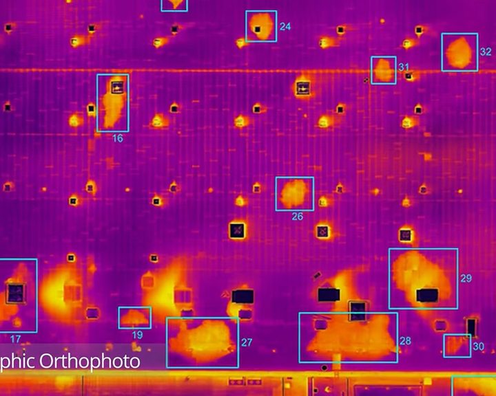
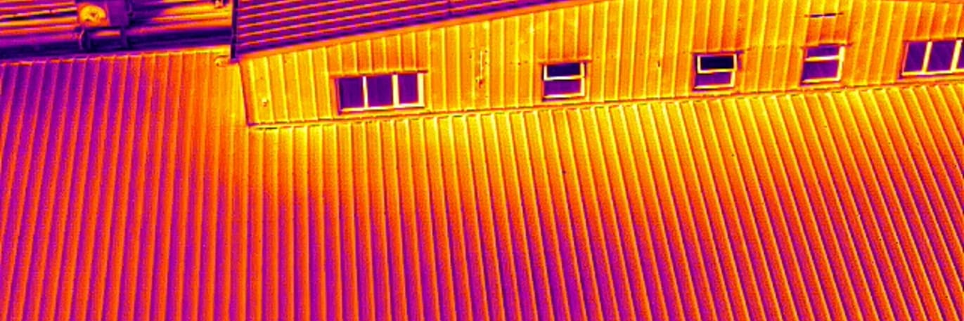
Engineers With Drones combined drone technology, thermography and orthophotos to locate water ingress across 5.2 hectares of flat bitumen roof on a large commercial building.
Complex surveys and inspections require more than just a pilot. Our engineers can help you scope your requirements and indentify the right approach.


