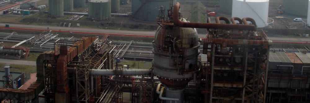
Scaffolding a flare stack or pipe rack for an external inspection can add days of setup before work begins, at significant cost and with personnel at height throughout. A drone inspection can cover the same structure from a safe standoff distance in a single flight — no scaffolding, no rope access, and no shutdown.
Where internal inspection of storage tanks or pressure vessels is required, a confined space drone can inspect the full interior without any person entering the confined space — no confined space entry permit, no decommissioning, and no standby rescue team to arrange.
What does a drone inspection cover on an oil and gas site?
Externally, a drone can inspect flare stacks, pipe racks, wellheads, structural steelwork, and storage tank exteriors — all from a safe standoff distance with no access equipment required. Thermal imaging can detect product leaks, steam tracing failures, and corrosion under insulation while the plant remains operational.
Internally, a confined space drone can inspect storage tanks, pressure vessels, and processing vessels without any person entering the confined space. The drone transmits 4K video to a pilot on the ground in real time, and every defect is recorded for inclusion in the final report.
More about confined space drone inspectionsCan inspections be carried out while the plant is operational?
External drone surveys operate at a safe standoff distance and do not interact with plant equipment — visual and thermal inspections can typically be carried out while the facility remains fully operational. This includes live flare stack inspections, where the drone operates at a safe standoff distance while the flare remains lit.
For internal confined space inspection, the drone can typically enter through an access hatch while the tank or vessel remains in service, provided the internal environment is within the drone’s operating limits. Every site is assessed individually to confirm feasibility before any work begins.
Discuss your site requirementsDo you offer flare stack inspections?
Yes — flare stack inspection is a specialist service we deliver across Ireland, including live-stack inspections while the flare remains lit. Flare stacks are covered on this page at overview level because they sit within the wider oil and gas picture, but the detail lives on its own page.
See the dedicated flare stack inspection pageDo you offer other energy sector services?
Yes. Oil and gas is one part of our energy sector work — we also inspect wind turbines, utility-scale solar farms, and high-voltage power grid infrastructure. All of these are covered on the energy sector page.
See our full energy sector services Wind turbine inspectionsA drone can inspect pipe racks, structural steelwork, wellheads, and storage tank exteriors from a safe standoff distance — with no scaffolding, no rope access, and no requirement to shut down or cool the asset. What a drone can detect externally: corrosion, coating failure, physical damage, structural deformation, and lightning conductor condition. Flare stack inspection is a specialist service in its own right — more about flare stack inspections.
What about working at height regulations in Ireland?
The Safety, Health and Welfare at Work (Work at Height) Regulations 2006 (S.I. No. 318 of 2006) require that work at height be avoided where it is reasonably practicable to do so. A drone inspection satisfies this requirement at the first step of the hierarchy of control — the inspection is carried out from a safe standoff distance with no personnel working at height.
Because no one leaves the ground, the duties to provide fall protection, guardrails, or rescue arrangements for work at height do not arise. The regulation’s framework — avoid, prevent, minimise — is satisfied without progressing beyond the first obligation.
More about our regulatory complianceWhere can a drone fly in industrial settings in Ireland?
All drone operations in Ireland are regulated by the Irish Aviation Authority under the EASA framework (S.I. No. 24 of 2023). Engineers with Drones holds an EASA Specific Category Operational Authorisation (IRL.UAS.AUTH1002) — the first company in Ireland to receive this level of authorisation — which permits operations beyond Open category limits: over populated areas, near airports, and above sensitive infrastructure.
For active industrial sites, a site-specific Risk Assessment and Method Statement is typically prepared and agreed with the site health and safety officer before fieldwork begins.
More about our operational authorisations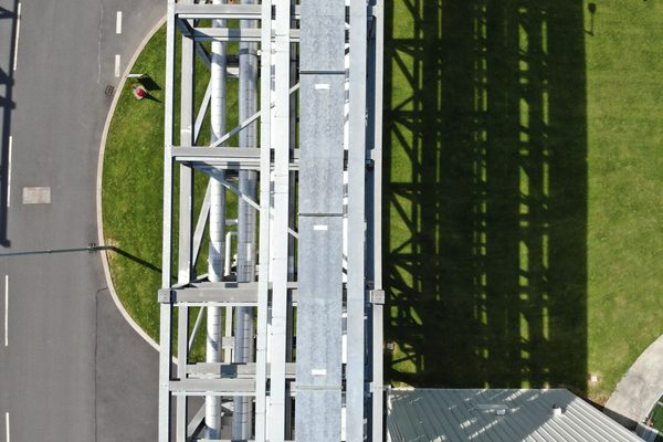
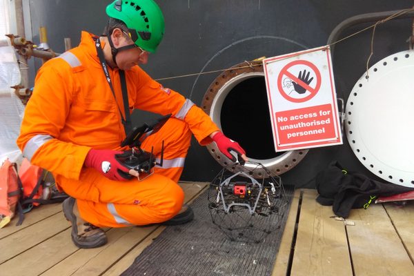
A confined space drone can inspect the full interior of storage tanks, pressure vessels, and processing vessels without any person entering the confined space. The drone transmits 4K video to a pilot on the ground in real time. What a drone can detect internally: corrosion, pitting, coating failure, weld condition, floating roof condition, and water ingress. A client monitoring station can be deployed so that an accompanying inspector or engineer can direct the inspection in real time.
Can a tank be inspected without draining it?
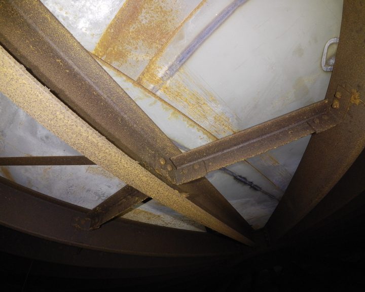
Yes. A confined space drone can typically inspect the roof structure, upper walls, and internal floating roof of a storage tank without draining the product. Access is usually through an existing hatch, and the drone operates above the liquid level throughout the inspection. This avoids the cost, time, and environmental handling associated with draining and cleaning a tank.
Where a full internal survey including floor condition is required, the tank must be empty. Every site is assessed individually to confirm exactly what coverage is achievable given the tank configuration, product level, and access points available.
More about confined space drone inspectionsWhat confined space regulations apply in Ireland?
The Safety, Health and Welfare at Work (Confined Spaces) Regulations 2001 (S.I. No. 218 of 2001) require that a person shall not enter a confined space unless it is not reasonably practicable to carry out the work without entry. A confined space drone inspection satisfies this requirement — the inspection is completed without any person entering the confined space.
Because no human entry takes place, there is no confined space entry permit to prepare, no decommissioning requirement, and no standby rescue team to arrange. All EWD operators who enter a confined space alongside the drone are confined space trained and competent in rescue procedures.
More about our regulatory compliance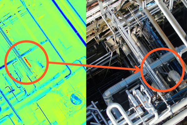
Drones equipped with thermal imaging cameras — operated by trained thermographers — can detect temperature anomalies that indicate product leaks, steam tracing failures, blocked lines, and corrosion under insulation while the plant remains operational. A thermal survey can identify problems before they become visible externally or cause unplanned downtime.
What can thermal imaging detect on oil and gas infrastructure?
Thermal imaging can detect product leaks (temperature difference between the escaping product and the surrounding pipe or vessel), steam tracing failures (a cold tracer line where it should be hot), blocked or restricted lines (a temperature drop or rise along the pipe run), and overheating equipment such as pump bearings and motor housings.
Corrosion under insulation can also produce thermal signatures — wet or deteriorated insulation transfers heat differently from dry, intact insulation, and this difference can be visible on a thermal image before any external sign of corrosion appears.
More about thermal imaging inspectionsDo I need to shut down equipment for a thermal survey?
No. Thermal imaging is passive — the camera detects heat that is already being emitted by the equipment. The drone operates at a safe standoff distance and does not interact with plant equipment. A thermal survey can typically be carried out while the facility remains fully operational.
More about thermal imaging inspections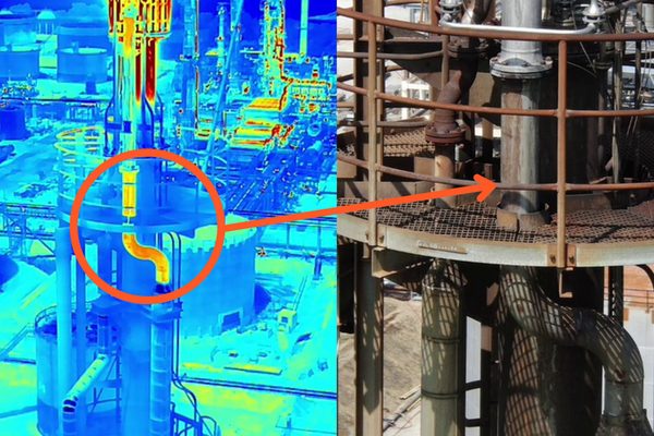
Every defect is described, categorised by type, and assigned a severity level. The report includes a simple orientation diagram showing each defect’s location within the asset — accessible to non-technical stakeholders without specialist software, and ready to hand directly to your maintenance or engineering team. Skip to information about drone inspection deliverables...
What is the typical turnaround time?
An external survey of flare stacks, pipe racks, and structural steelwork can typically be completed in a single site visit. Internal confined space inspections of tanks and vessels may extend the deployment, depending on the number and size of assets to be inspected.
The full defect classification report is typically delivered within a few working days of the inspection. Every site is different, so timelines are confirmed before any work begins based on the specific assets, scope, and deliverables required.
Discuss your inspection timelineFull-height external coverage of flare stacks, pipe racks, and structural steelwork from a safe standoff distance. No access equipment, no shutdown — including live flare stack inspections while the flare remains lit.
The confined space drone inspects storage tanks, pressure vessels, and processing vessels without any person entering the confined space. No permit, no decommissioning, no standby rescue team required.
Thermal cameras operated by trained thermographers can detect product leaks, steam tracing failures, blocked lines, and corrosion under insulation while the plant remains fully operational.
Storage tanks and pressure vessels can typically be inspected internally without draining product or taking the asset offline. The drone enters through an existing access hatch and operates above the liquid level.
A single deployment can cover wellheads, pipe racks, flare stacks, storage tanks, and structural steelwork — systematically, with GPS-tagged imagery referenced to identifiable site features.
Each defect described, categorised, and severity-rated. Includes an orientation diagram showing each defect’s location within the asset — no specialist software needed to read it.
Conventional external inspection of pipe racks, structural steelwork, and elevated assets requires scaffolding or rope access — at significant cost and with personnel working at height in a hazardous industrial environment. A drone survey can cover the complete external structure from a safe standoff distance in a single flight, with no access equipment and no workers at height. For flare stacks specifically — including live-stack inspections — see the dedicated flare stack page.
The confined space drone enters through an access hatch and inspects the full interior of storage tanks, pressure vessels, and processing vessels, transmitting 4K video to the pilot in real time. A client monitoring station can be deployed so that an accompanying inspector or engineer can direct the inspection as it happens. No person enters the confined space at any point — no confined space entry permit, no decommissioning, no standby rescue team required.
Tell us what you need to know, and we will work with you to design actionable deliverables that give you the outcomes you need.
A typical external survey delivers a full-height photographic record of flare stacks, pipe racks, wellheads, and structural steelwork — with GPS-tagged imagery and thermal data where required. An internal confined space inspection delivers 4K video of the tank or vessel interior, with still photography of every identified defect.
Faults are usually compiled into a defect classification report: each defect described, categorised by type, and assigned a severity level. A simple orientation diagram shows each defect’s location within the asset, accessible to non-technical stakeholders without specialist software and ready to hand directly to a maintenance or engineering team.
Every corrosion patch, coating failure, and structural defect photographed with GPS reference from base to tip.
High quality footage of tank and vessel interiors supported by still photography of every identified defect.
Thermal data captured by trained thermographers — detect leaks, blockages, and CUI before they become visible externally.
Each defect described, categorised, and severity-rated. An orientation diagram shows where every fault sits within the asset.
Engineers With Drones used a confined space drone to inspect a large steel ethanol tank on a natural gas processing facility in Ireland — eliminating the need for scaffolding or personnel entry.
Complex surveys and inspections require more than just a pilot. Our engineers can help you scope your requirements and indentify the right approach.


