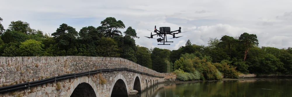
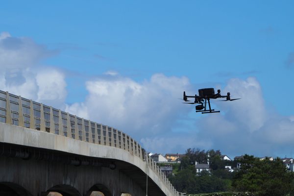
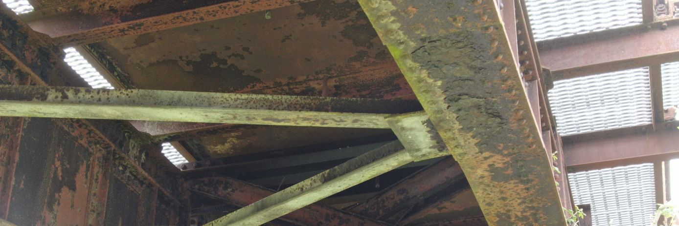
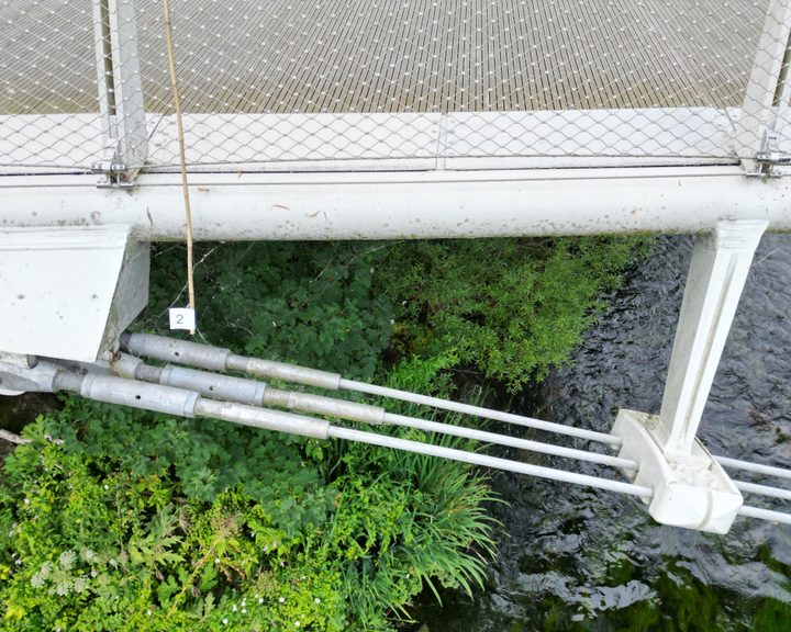
The underside of a bridge deck — the soffit — is typically inaccessible without a mobile platform or bridge inspection unit. A drone inspection can capture the full soffit, piers, abutments, parapets, and expansion joints in a single pass, without lane closures, without access equipment, and with every identified defect GPS-tagged and mapped in an annotated condition report.
For long linear structures — causeways, coastal embankments, tidal crossings — the challenge is not just capturing the imagery but making it usable. EWD overlays client chainage drawings onto every orthophoto and 3D model so every defect can be expressed as a distance from a known reference point. Field crews can locate and act on findings without guesswork.
What does a drone bridge inspection cover?
A drone bridge inspection typically covers every face of the structure in a single pass: the deck soffit (underside), piers, abutments, parapets, expansion joints, and bearings. The drone operates at an oblique angle, capturing all structural elements without needing to fly directly over the road surface.
What a drone inspection can detect: concrete spalling, cracking, and delamination; reinforcement corrosion and water staining; bearing deterioration; scour damage to piers and abutments; joint failure; and drainage issues.
See what a full structural inspection coversWill the bridge need to be closed or traffic managed?
No. Oblique flight paths keep the drone clear of the road surface throughout the inspection. Traffic and pedestrians flow normally with no lane closures, no traffic management, and no disruption at any point.
The drone operates from a safe standoff position adjacent to the structure. No access equipment is required on the road surface, and no personnel work at height or in live traffic.
More about operating without disruptionWhat deliverables will I receive?
A typical bridge inspection delivers a full photographic survey of all accessible faces, an annotated condition report with every defect GPS-tagged and mapped, and a photogrammetric 3D model where the structure geometry supports it. For linear structures, chainage-referenced orthophotos are provided with the client's own chainage markings overlaid.
Every defect is categorised by type, assigned a severity level, and located on a simple orientation diagram — ready to hand directly to a maintenance or repair team without specialist software.
Discuss your deliverable requirementsCan drones inspect long linear structures like causeways?
Yes. EWD regularly surveys causeways, coastal embankments, and tidal crossings using a systematic approach designed specifically for linear infrastructure. The methodology includes side-on and oblique orthophotos (nadir imagery alone misses wall faces and structural detail), chainage-referenced defect marking, and low-tide capture scheduling for tidal structures.
For structures used by the public, all processed deliverables are anonymised before delivery: faces and number plates are removed and raw captures deleted.
More about chainage referencing for linear structuresThe underside of a bridge deck — the soffit — is typically inaccessible without a mobile platform or bridge inspection unit. A drone inspection can capture the full soffit, piers, abutments, expansion joints, and bearings in a single pass, with no lane closures and no access equipment. What a drone inspection can detect: concrete spalling and cracking, reinforcement corrosion, water staining, bearing deterioration, scour damage to piers and abutments, joint failure, and drainage issues.
What about working at height regulations in Ireland?
The Safety, Health and Welfare at Work (Work at Height) Regulations 2006 (S.I. No. 318 of 2006) require that work at height be avoided where it is reasonably practicable to do so. A drone inspection satisfies this requirement at the first step of the hierarchy of control — the inspection is carried out from a safe standoff distance with no personnel working at height.
Because no one leaves the ground, the duties to provide fall protection, guardrails, or rescue arrangements for work at height do not arise. The regulation's framework — avoid, prevent, minimise — is satisfied without progressing beyond the first obligation.
More about our regulatory complianceWhere can a drone fly near roads and public infrastructure in Ireland?
All drone operations in Ireland are regulated by the Irish Aviation Authority under the EASA framework (S.I. No. 24 of 2023). Engineers with Drones holds an EASA Specific Category Operational Authorisation (IRL.UAS.AUTH1002) which permits operations beyond Open category limits: over populated areas, near infrastructure, and in complex airspace environments.
A site-specific Risk Assessment and Method Statement is typically prepared and agreed with the relevant authority or site health and safety officer before fieldwork begins. Oblique flight paths keep the drone clear of the road surface throughout, so no lane closures or traffic management are required.
More about our operational authorisations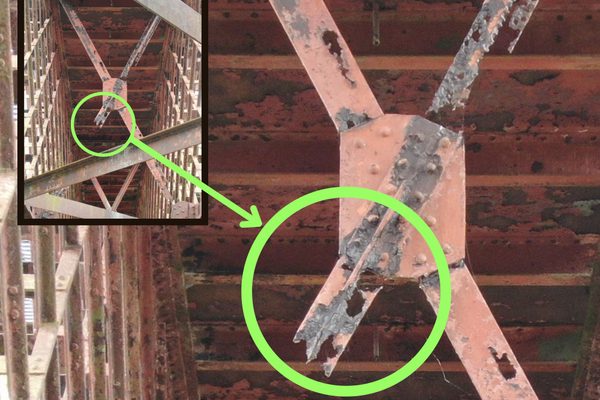
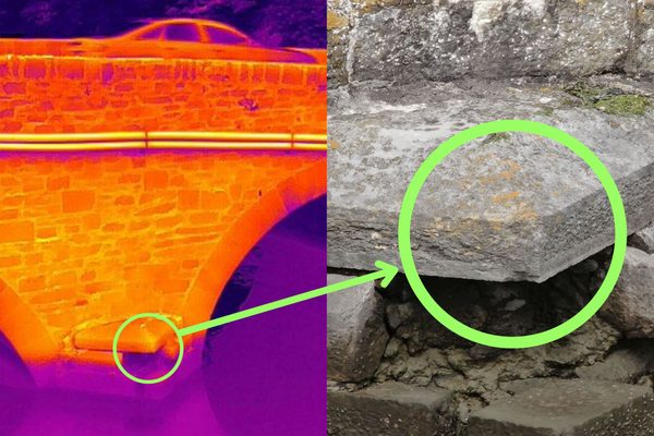
Thermal imaging can identify delaminated areas across the full bridge deck surface without manual contact. The chain drag test — the traditional alternative — is labour-intensive and prone to inconsistency. A thermal drone pass can cover the entire deck in a fraction of the time and deliver a georeferenced map of delaminated zones, alongside a visual inspection of the full structure for spalling, cracking, corrosion, joint failure, and vegetation growth.
How does thermal delamination detection work?
Delaminated concrete heats and cools at a different rate from sound concrete because the air gap created by the delamination acts as an insulator. A thermal camera mounted on the drone detects these temperature differences across the bridge deck surface, identifying delaminated zones that are invisible to the naked eye.
The traditional chain drag test requires personnel on the deck physically dragging a chain and listening for changes in acoustic response — it is labour-intensive, lane-by-lane, and subjective. A thermal drone pass can cover the full deck surface in a single flight and provide a georeferenced output that can be compared against future inspections to track deterioration over time.
More about thermal imaging inspections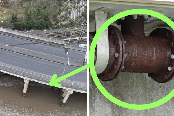
A kilometre-long orthophoto is only useful if defects can be located precisely in the field. EWD overlays the client's own chainage drawings onto every orthophoto and 3D model, and marks unique features — bridges, walls, transitions — so every defect can be expressed as a distance from a known reference point. Field crews can locate and act on findings without guesswork. This is standard practice for causeways, coastal roads on embankments, and any linear structure where precise location matters.
What is chainage referencing and why does it matter?
Chainage referencing is the practice of marking every defect's position as a distance along the structure from a known reference point — for example, "spalling at chainage 340m, east face." Without chainage referencing, a defect photograph of a kilometre-long causeway is of limited practical use because a field crew cannot locate the exact spot to repair it.
EWD overlays the client's own chainage drawings directly onto orthophotos and 3D models, and marks unique structural features (bridges, walls, transitions) as additional reference points. Every defect in the condition report is expressed as a chainage distance, so maintenance teams can locate and act on findings without a return site visit for location finding.
See the Galway causeways case study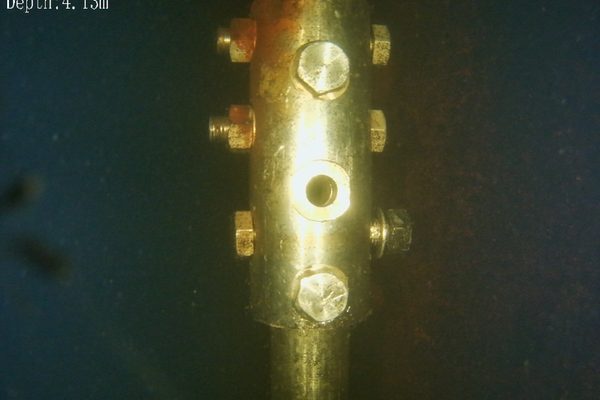
A bridge is only as sound as its foundations. Submerged piers, abutments, and cross-bracing are subject to scour, corrosion, and marine growth that can compromise structural integrity — yet these areas are rarely inspected because of the cost and complexity of deploying divers. An underwater ROV can capture high-resolution imagery of submerged structural elements without putting a diver in the water, providing the visual evidence needed to assess foundation condition, fastener integrity, and biofouling.
What is an underwater ROV?
An underwater ROV (Remotely Operated Vehicle) is a tethered, submersible drone that transmits live video from beneath the water surface to a pilot on the surface. Unlike an aerial drone, the ROV is not flying — it is a buoyancy-controlled unit with thrusters that allow it to manoeuvre around submerged structures.
For bridge inspections, an underwater ROV can examine piers, abutments, and cross-bracing below the waterline without deploying a diver — no dive team, no confined-space entry into submerged areas, and no disruption to the structure or the waterway.
Discuss your underwater inspection requirementsIs a human diver still better than an underwater ROV?
It depends on what you need. A diver can physically interact with the structure — clean a surface, take a physical sample, tighten a bolt, or carry out a repair. An ROV can only observe, record, and measure.
For pure visual inspection, however, an ROV has practical advantages: no dive team to arrange, no standby rescue diver, no risk to personnel in confined submerged spaces, longer bottom time, and the ability to operate safely in zero-visibility or contaminated water where a diver should not be deployed. For many bridge inspections, an ROV is the safer, faster, and more practical first option — and if the footage reveals a problem that needs hands-on intervention, a diver can then be deployed to the exact location with a clear brief.
Discuss the right approach for your structure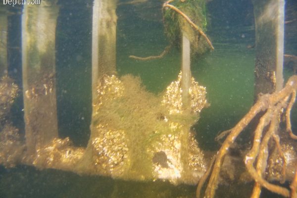
Oblique flight paths keep the drone clear of the road surface throughout — no lane closures, no traffic management, no disruption to road users. The drone operates from a safe standoff position adjacent to the structure. No access equipment is required on the road surface, and no personnel work at height or in live traffic.
Bridge inspections in publicly accessible areas may incidentally capture vehicles, number plates, or faces in raw imagery. EWD processes all deliverables to remove identifiable personal data before delivery — faces and number plates are anonymised using processing software, and original raw captures are deleted once the processed deliverables are confirmed. The final output contains no identifiable personal data.
How does GDPR affect a bridge inspection?
Bridge inspections in public areas may incidentally capture vehicles, number plates, or faces in raw imagery. Under the General Data Protection Regulation (Regulation (EU) 2016/679) as given effect in Irish law by the Data Protection Act 2018, this constitutes processing of personal data and must be addressed before deliverables are handed over.
EWD processes all deliverables to remove identifiable personal data before delivery: faces and number plates are anonymised using processing software, and original raw captures are deleted once the processed deliverables are confirmed. The final output contains no identifiable personal data.
More about our GDPR complianceWhat happens to the raw footage after processing?
Original raw captures are deleted once the processed deliverables have been confirmed and the client has accepted the final output. No raw imagery is retained beyond the processing window.
This reflects the data minimisation and storage limitation principles set out in Article 5 of the GDPR: no database of vehicle number plates, no archive of identifiable faces, and no long-term storage of unredacted capture data. The only record that remains is the anonymised, processed deliverable provided to the client.
More about our data handlingDoes the same process apply to private structures?
Yes. EWD applies the same anonymisation and deletion process to every inspection regardless of whether the structure is publicly accessible. Where a bridge is on private land with no public access, the likelihood of incidental capture is lower, but the processing standard is the same.
The applicable legal basis for processing may differ — public structures typically engage the legitimate interest assessment pathway under the Data Protection Act 2018, while private-structure inspections may operate under a contractual necessity basis — but the operational safeguards EWD applies do not change. EWD can advise on this as part of the pre-inspection site assessment.
More about our regulatory complianceOblique flight paths keep the drone clear of the road surface throughout. Traffic and pedestrians flow normally with no disruption at any point during the inspection.
The soffit and all bridge faces can be captured without any access equipment. No mobile platforms, no bridge inspection units, no workers at height or in water.
Every identified defect is GPS-tagged and mapped on an annotated condition report. Maintenance teams can locate faults precisely without a return site visit for location finding.
For causeways and linear structures, EWD overlays client chainage drawings on all deliverables. Every defect is expressed as a distance from a known reference point — field crews can act without guesswork.
A thermal drone pass can identify delaminated deck areas across the full bridge surface — more reliable and far faster than the chain drag test, with a georeferenced output map.
For structures used by the public, all processed deliverables are anonymised before delivery. Faces and number plates are removed and raw captures deleted.
The deck soffit, piers, abutments, parapets, and expansion joints are all captured in a single pass — without mobile platforms, lane closures, or scaffolding. What a drone inspection can detect: concrete spalling, cracking, and delamination; reinforcement corrosion and water staining; bearing deterioration; scour damage to piers and abutments; joint failure; and drainage issues.
For long linear structures — causeways, coastal embankments, tidal crossings — a 3D model or orthophoto is only useful if every defect can be located precisely in the field. EWD overlays client chainage drawings on all deliverables so every defect is expressed as a distance from a known reference point. Tidal structures are typically captured at low tide — water distorts photogrammetric data and obscures the base of the structure. All processed deliverables are GDPR-anonymised before delivery.
Tell us what you need to know, and we will work with you to design actionable deliverables that give you the outcomes you need.
A typical bridge inspection delivers a full photographic survey of all accessible faces — soffit, piers, abutments, parapets, and expansion joints — with every defect GPS-tagged and mapped. Where thermal imaging is specified, a georeferenced thermal map of the deck surface is also produced, identifying delaminated zones that are invisible to the naked eye. For linear structures, chainage-referenced orthophotos are provided with the client's own chainage markings overlaid, and a photogrammetric 3D model can be produced where the structure geometry supports it.
Faults are usually compiled into a defect classification report: each defect described, categorised by type, and assigned a severity level. A simple orientation diagram shows each defect's location within the structure, accessible to non-technical stakeholders without specialist software and ready to hand directly to a maintenance or repair team.
Every soffit, pier, abutment, parapet, and expansion joint photographed in high resolution from every accessible angle.
Client chainage drawings overlaid on orthophotos and 3D models. Every defect located by chainage distance for field crews.
A measurable digital twin of the structure, suitable for dimensional analysis and comparison against future inspections.
A georeferenced thermal map of the deck surface identifying delaminated zones invisible to the naked eye — more reliable and far faster than a chain drag test.
Each defect described, categorised, and severity-rated. An orientation diagram shows where every fault sits within the structure.
Drone bridge inspection case study — using a drone to conduct a detailed inspection of a 350-metre pedestrian bridge with an intricate cable-truss design that makes thorough manual inspection difficult.
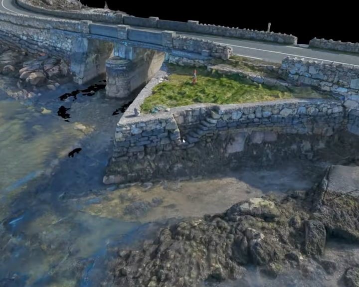
Engineers With Drones surveyed four historic stone causeways in west Galway using photogrammetry to create high-resolution 3D models and technical deliverables.
Complex surveys and inspections require more than just a pilot. Our engineers can help you scope your requirements and indentify the right approach.


