Large commercial building 5.2 hectares. Three cutting-edge technologies. One map of exactly where the problems are.
Overview
The Job at a Glance
A thermal drone survey of a 5.2-hectare flat bitumen commercial roof, combining drone technology, thermography, and orthophotography to map surface heat variations and identify hidden moisture intrusion beneath the felt.
5.2 hectares
The total flat roof area surveyed safely and efficiently. Comparable in size to two or three average Irish housing estates. No personnel operating at height. No scaffolding or ropes required.
Three datasets
RGB orthophoto, daytime thermal orthophoto, and nighttime thermal orthophoto - captured across two sessions on the same day for total transparency.
Custom ground control points
In-house developed GCPs, compatible with both RGB and thermal sensors, deployed across the full roof area to ensure precise geospatial data.
Three deliverables
A plain-English PDF report, a marked-up thermal orthophoto, an unmarked thermal orthophoto, and an RGB orthophoto - all instantly actionable in the field on an iPad.
Comparative methodology
Why they chose us
To find hidden moisture across 5.2 hectares of flat roof, the client needed a solution that was faster than a foot survey and could detect what the naked eye cannot. Drone thermography delivered all three datasets in a single day.
Area surveyed
5.2 hectaresvs foot survey
The entire roof was covered safely and efficiently — equivalent to two or three average Irish housing estates.
Detection method
Thermal + RGBvs visual only
Differential thermal degradation revealed hidden moisture beneath the felt surface, invisible to the naked eye.
Deliverable
iPad-navigable mapsvs no location record
Annotated orthophotos gave the client's team a way to navigate directly to every problem area on site.
Efficient optionOur method
Using a drone
A quick, reliable, and cost-effective solution using our latest thermal-imaging technology.
Three datasets in one surveyRGB orthophoto, daytime thermal orthophoto, and nighttime thermal orthophoto — all captured in a single day.
5.2 hectares with zero downtimeThe entire roof was surveyed without any operational disruption or risk to assets below.
Hidden moisture intrusion foundDifferential thermal degradation revealed moisture beneath the felt surface, invisible to the naked eye.
Custom GCPs for absolute accuracyIn-house ground control points compatible with both RGB and thermal sensors ensured precise georeferencing across all datasets.
Defect locations navigable on iPadThe annotated orthophotos allowed the client's team to navigate directly to each problem area on site.
Instantly actionable deliverablesPDF report plus marked and unmarked thermal and RGB orthophotos — all ready to use in the field.
DeliverablesThree orthophotos and a PDF report
Manned approachTraditional method
Without a drone
The expensive, time-consuming traditional approach.
Walking 5.2 hectares on footManual inspection of a roof this size — equivalent to two or three housing estates — would take days and be physically demanding.
Moisture invisible to naked eyeSubsurface moisture beneath bitumen felt cannot be seen during a standard visual walkover inspection.
No systematic defect location recordA manual walkover cannot produce a georeferenced map of problem areas that field teams can navigate back to.
Invasive investigation requiredFinding and confirming subsurface moisture without thermal imaging would require disruptive and costly intrusive testing.
Operational impactDays on foot, no mapped output
The challenge
Finding invisible problems across a massive asset
Our client faced a significant challenge: managing 5.2 hectares of flat bitumen felt roof. To put the scale into perspective, an average housing estate in Ireland spans between one and three hectares. This asset was huge, and any undetected issues like leakage and moisture could easily lead to major malfunctions and exorbitant costs.
The question they brought to us was simple: could we provide a fast, low-cost solution using drone and thermal technology? They needed to find and eliminate water damage and moisture intrusion beneath the felt without walking the entire surface and relying on the naked eye - which simply cannot detect these hidden problems.
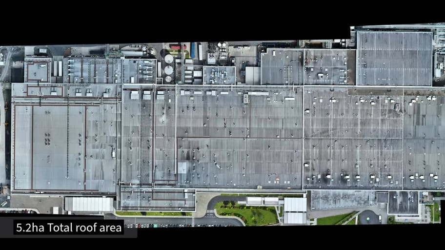
An orthophoto overview of the 5.2-hectare commercial roof area - roughly the size of two or three average Irish housing estates.
The Methodology
Three cutting-edge technologies
To provide the client with clear-cut conclusions, Engineers With Drones used three advanced technologies: precision drone flight, thermography, and orthophotography.
Orthophotography
Orthophotography is a highly precise surveying technique. An orthophoto is a precisely stitched collection of photographs where each image is orthorectified - meaning every pixel is viewed from directly overhead. The result is a single, geometrically accurate top-down image of the entire asset that can be measured and navigated without needing to step foot on the roof.
Thermography
A thermal orthophoto applies this exact principle to thermal imagery. Instead of a standard visual map, we deliver a thermographic map of the entire surface, precisely stitched and georeferenced. By combining an RGB orthophoto with daytime and nighttime thermal orthophotos, our engineers delivered a complete, instantly actionable picture of the asset that no single technology could achieve alone.
Precision drone flight
Due to the colossal scale of the roof, we deployed custom ground control points across the entire area. Developed in-house, these GCPs are compatible with both RGB and thermal sensors, ensuring the highest level of photogrammetric accuracy across all datasets.
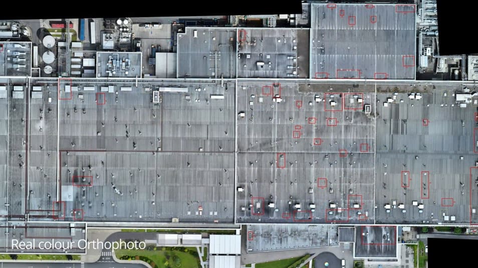
The RGB orthophoto deliverable with identified defect locations marked in red, allowing the client to navigate directly to each issue on site.
Analysis
Interpreting the thermal orthophoto
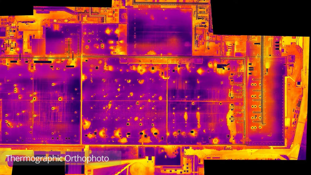
Once the nighttime dataset was processed, we created a precise thermographic map of the 5.2-hectare roof. In this thermal orthophoto, blue represents cold, red represents hot, and yellow sits in the middle.
We are more than just drone pilots; our primary qualifications are in engineering, and correctly interpreting a thermal orthophoto requires that technical expertise. A commercial roof of this size has numerous legitimate heat sources: vents discharging warm air, rain gutters, and downpipes. These all appear in the thermal imagery and must be accurately identified to prevent false defect reporting.
Vents and rain gutters
Vents naturally appear in large numbers across a roof like this. They present as discrete, defined heat sources and are easily identified by their shape and pattern. Rain gutters and downpipes present as repeating linear or point features along the edge; the heat radiating up from internal pipes makes them visible. These are expected, safe heat sources, not malfunctions.
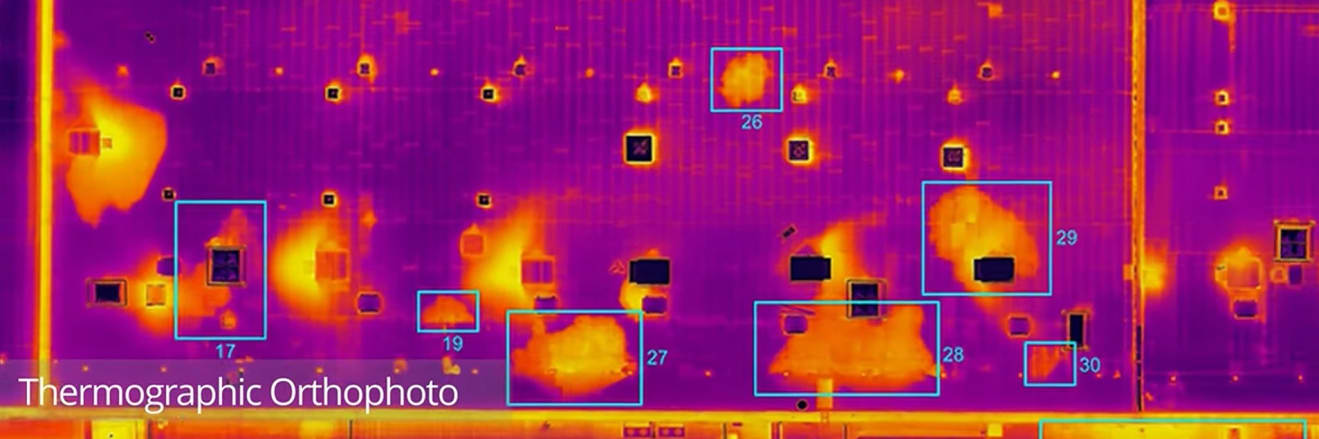
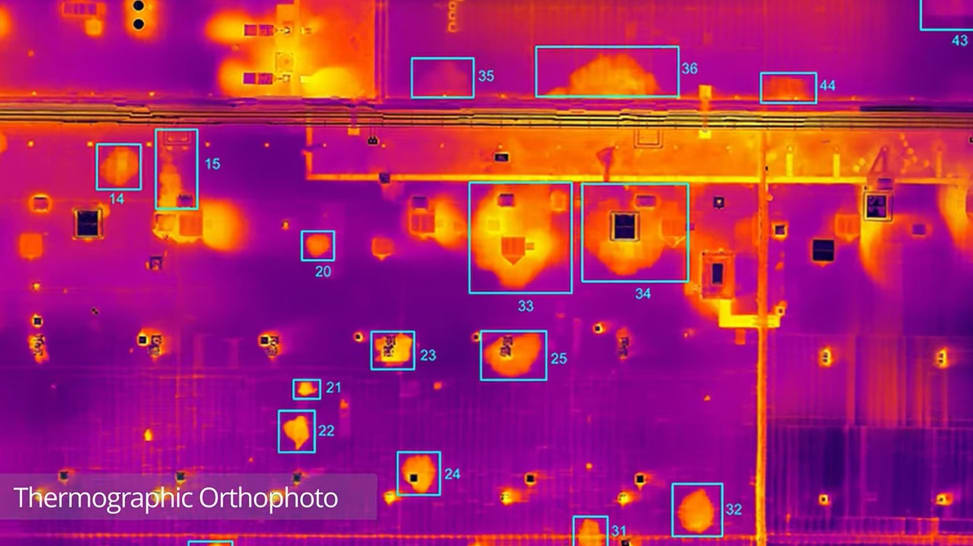
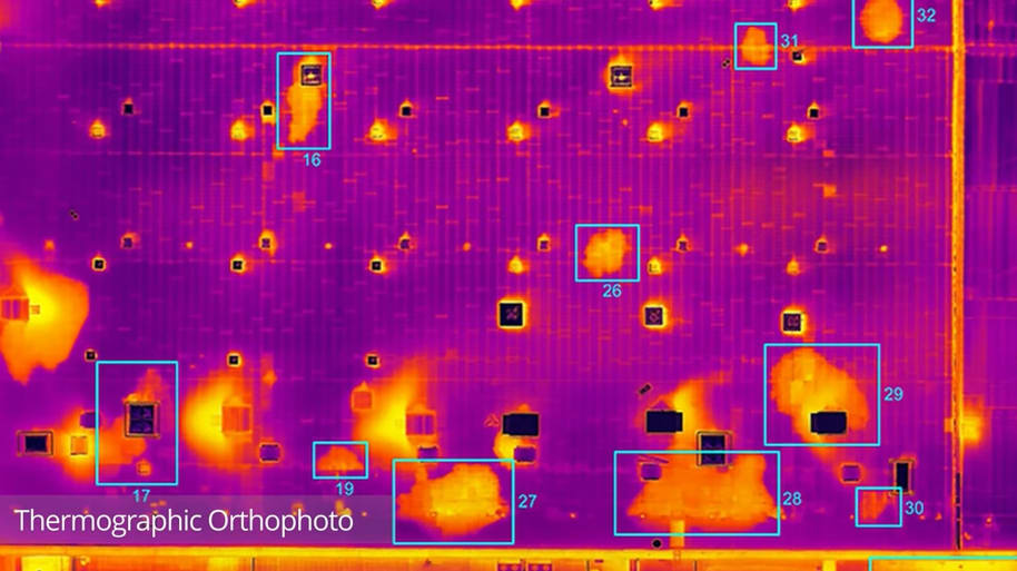
A thermographic orthophoto with identified defect locations numbered. Vents appear as defined point sources; water damage spreads in an organic inkblot pattern.
Water damage - the inkblot pattern
Moisture intrusion presents entirely differently. The critical indicator is what we refer to as the inkblot pattern: an irregular, diffuse area of retained heat with no logical external heat source. While a vent has a strict, defined shape, water damage spreads organically, as thermal energy radiates outward from the hidden moisture.
Water damage also frequently tracks along linear features, such as seams and overlaps in the felt where a breach has occurred. Distinguishing this structural failure from a standard building feature like a lightning conductor is exactly where our engineering backgrounds add the most value.
The inkblot pattern in detail - irregular, diffuse areas of retained heat with no external heat source. Each spread indicates water trapped beneath the bitumen felt.Another section of the thermographic orthophoto showing the density and distribution of water ingress across the roof surface.
Limitations
What the survey cannot do
Total transparency: if there is standing water on the roof at the time of the survey, the inspection cannot yield actionable results. Surface water generates its own thermal signature, completely masking the signature of the moisture trapped beneath the felt. In such cases, we prioritise reliable data over a quick finish; we will pause operations and return when the conditions are right.
Critical Factors
Why timing is everything in thermal surveying
We know what we're looking for, and we know how to find it - which means understanding that thermography behaves differently depending on the time of day. On a sunny afternoon, the solar heat absorbed by the roof overwhelms the thermal signature of any moisture intrusion underneath. The daytime dataset we captured confirmed this: it showed a building with no apparent defects because the sun's heat dominated the data. We captured this deliberately to demonstrate exactly what bad data looks like.
Actionable data is captured after dark. During the day, the matte black felt roof absorbs intense solar heat, and any water trapped beneath it does the same. After sunset, the dry areas of the roof cool rapidly. The wet areas, however, retain their heat longer because the trapped water stores more thermal energy. The optimal window for our engineers to detect this variation is roughly two to three hours after sunset on a cold day - after the dry roof has cooled, but before the wet areas have cold-soaked to the surrounding temperature.
Wait too long, and the hidden problems disappear again. A pre-dawn survey on this same roof would reveal nothing, as the water would have cold-soaked overnight to match the temperature of the dry areas.
Video footage
Thermal Roof Inspection
See the thermal orthophoto data and our expert defect identification process in action. Watch exactly how three distinct datasets - RGB, daytime thermal, and nighttime thermal - combine to reveal hidden moisture intrusion and deliver a complete, instantly actionable picture of the roof.
Outcome
Instantly actionable data
In this example, the client needed actionable answers quickly. They received a plain-English PDF report alongside three distinct deliverables: a thermal orthophoto with every issue clearly marked, an unmarked thermal orthophoto, and an RGB orthophoto showing each location in real colour. Using just an iPad, anyone in the client's team could zoom into the maps and walk straight to the precise location of the hidden moisture.
When managing 5.2 hectares of flat roof, the difference between blindly walking the surface hoping to spot an invisible problem, versus navigating directly to verified targets, is monumental. It transforms a needle-in-a-haystack guess into a rapid, targeted, and cost-effective remediation plan.
On this occasion, the client was immediately able to go about fixing the issues that we identified. This process starts with human verification that the issue is indeed water ingress in need of repair. With a precise location and a picture of what they're looking for, this is quick and easy. From there, repair work can immediately begin.
Let's talk
Speak to an engineer about your project
Complex surveys and inspections require more than just a pilot. Our engineers can help you scope your requirements and indentify the right approach.