Aerial view of rural farmland for solar farm photogrammetric mapping

Photogrammetry mapping for solar farm development

Survey-grade mapping of 150-hectare site for renewable energy pre-construction assessment
Comparative methodology

Why they chose drone-based photogrammetry

For this 150-hectare solar farm mapping project, we chose drone-based photogrammetry because it delivered survey-grade topographical data across the entire site in 2.5-3 days of fieldwork, with complete deliverables within 2.5-3 weeks - far faster and more cost-effective than traditional ground-based surveying for large-area coverage.

Speed
2.5-3 days fieldwork vs weeks or months of ground surveying

Drone-based photogrammetry captured 150 hectares in under 3 days of fieldwork. Traditional ground-based surveying of the same area would have required weeks or months with a significantly larger field team.

Data quality
Survey-grade 2.2cm GSD + orthophoto + DEM/DSM vs limited data without comprehensive coverage

Complete topographical survey with high-resolution orthophoto, digital elevation model, and digital surface model delivered in one dataset - including vegetation heights, infrastructure, and terrain features that ground surveys struggle to capture comprehensively.

Cost
Cost-effective for large-area mapping vs significantly higher cost for traditional survey

The efficiency of drone-based photogrammetry over large areas delivers substantial cost savings compared to deploying ground survey teams across 150 hectares of varied farmland terrain.

Efficient option Our method

Using photogrammetry

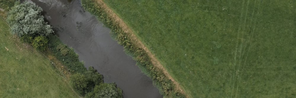
A fast, accurate, and cost-effective solution for large-area topographical surveying using drone-based photogrammetry.

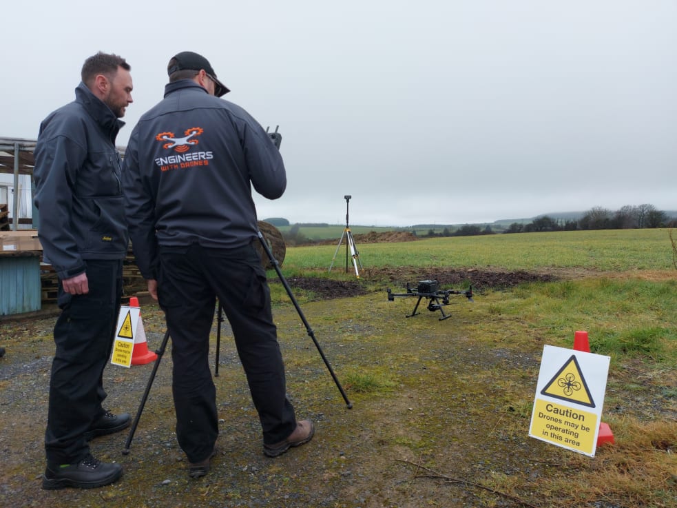
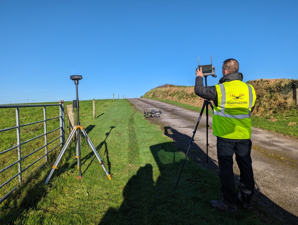
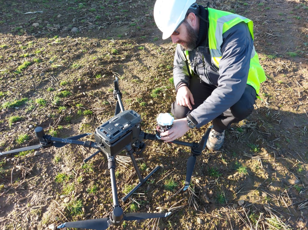
  • 2.5-3 days fieldwork to capture 150 hectares The entire site was captured in under 3 days of fieldwork, with the drone covering large areas efficiently at 80m altitude with 80% front and side overlap.
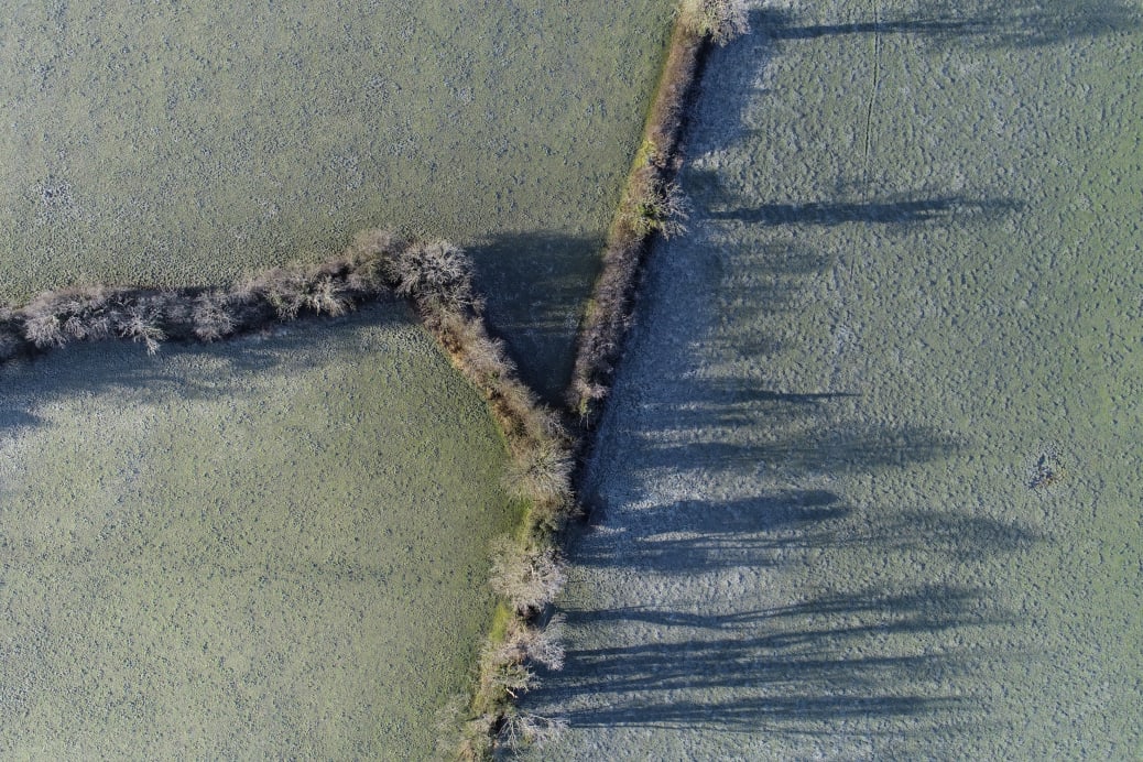
  • Survey-grade accuracy at 2.2cm ground sample distance High-resolution capture providing survey-grade accuracy suitable for engineering design software, solar farm CAD modelling, and planning applications.
  • Complete topographical survey including all vegetation heights, infrastructure, and terrain features Trees, hedges, walls, buildings, rivers, roads, and elevation changes all captured in a single survey pass - data that ground teams would need multiple mobilisations to collect.
  • High-resolution orthophoto, DEM, and DSM delivered Geometrically corrected orthophoto for visual assessment, bare-earth DEM for terrain analysis, and DSM including vegetation and structures for comprehensive shading analysis.
  • Data formatted for direct import into solar farm CAD software Delivered in formats compatible with specialised solar farm design software, enabling immediate panel placement modelling, shading analysis, and energy production calculations.
  • Full deliverables within 2.5-3 weeks total project time From fieldwork to final data delivery, the complete project was turned around in under three weeks - maintaining the client's solar development timeline.
Project status Completed - data delivered for solar farm design
Traditional approach Without a drone

Without a drone

The expensive, slow, and data-limited traditional approach.

  • Weeks or months of ground-based surveying for 150 hectares A ground survey team would require weeks or months to cover 150 hectares of farmland - with significantly more personnel and equipment deployed across the site.
  • Significantly higher cost for large-area coverage The labour cost alone for ground surveying 150 hectares far exceeds drone-based photogrammetry, with additional costs for equipment, transport, and site access coordination.
  • Limited vegetation height data - difficult to capture tree and hedge heights comprehensively Ground surveyors struggle to measure vegetation heights accurately across large areas, making comprehensive shading analysis difficult without additional survey work.
  • No high-resolution orthophoto for visual site assessment Traditional surveys produce point data and contour lines but lack the visual context of a geometrically corrected orthophoto for intuitive site understanding.
  • Extended timeline delays solar farm development planning The extended survey timeline pushes back planning applications, design work, and construction - potentially delaying the entire solar farm development by months.
  • Incomplete terrain data for comprehensive shading analysis Without comprehensive coverage of vegetation and terrain features, shading analysis is based on incomplete data - risking suboptimal panel placement and reduced energy production.
Operational impact Higher cost, slower delivery, limited data
The challenge

Pre-construction site assessment for solar development

Solar farm development in Ireland has grown significantly as landowners and energy companies recognize renewable energy opportunities. As Bob Foley, founder of Engineers With Drones, observes: "A lot of farmers would think, I can farm cows or I can farm sun. One of them takes a lot of energy and effort. The other one generates a lot of energy and doesn't take a lot of effort at all." Particularly for farmers with poor agricultural land but good sun exposure, solar farming presents an attractive alternative.

Solar development companies work with landowners to assess site potential before committing to construction. A solar development company engaged Engineers With Drones to map approximately 150 hectares of farmland in Ireland - a site located along a river floodplain with varied topography and active agricultural use.

The challenge was to deliver survey-grade photogrammetric data across this large, varied site with accuracy sufficient for engineering design software, within a tight timeline and budget. Traditional ground-based surveying of 150 hectares would require weeks or months of fieldwork with significant cost, and would struggle to capture comprehensive vegetation heights and terrain features across such a large area.

The client needed comprehensive topographical data to assess terrain suitability, analyze shading patterns, evaluate sun exposure, and provide input data for specialized solar farm design software. This data would determine whether the site was viable for solar development and enable detailed panel placement modeling.

Overview

The Project at a Glance

Survey-grade photogrammetric mapping of 150-hectare site for solar farm pre-construction assessment. Complete topographical survey, orthophotos, and terrain models delivered for renewable energy site evaluation.

Farmland site in Ireland

150-hectare farmland site along river floodplain with varied topography and active agricultural use.

2.2cm Ground Sample Distance

Survey-grade resolution captured at 80m altitude with 80% front and side overlap for maximum accuracy.

Solar farm site assessment

Pre-construction mapping for renewable energy development including terrain, vegetation, and shading analysis.

2.5-3 weeks delivery

Complete project from fieldwork to final deliverables - significantly faster than traditional surveying methods.

Methodology

Ground control strategy for vegetated farmland

Survey-grade photogrammetry requires accurate ground control points to ensure positional accuracy throughout the dataset. However, standard spray-painted ground control targets don't work effectively on vegetated farmland.

Bob Foley explains the solution: "Because we're dealing with vegetation, spray painted ground control wasn't great so we used our own custom ground control boards which were about 60 centimeters square." These custom boards show up clearly at the project's 2.2cm ground sample distance and can be positioned across vegetated farmland where spray paint would be ineffective.

Engineer setting up ground control equipment for photogrammetric survey

Ground control was deployed throughout the 150-hectare site before flight operations, with positions surveyed to provide accurate reference points for photogrammetric processing. This ensured the final deliverables would meet survey-grade accuracy requirements for engineering software.

Methodology

Flight planning and data capture

Engineers planning photogrammetric mapping mission for solar farm site

The survey was flown at 80 meters above ground level (AGL), maintained consistently throughout the site to ensure uniform ground sample distance. This altitude delivered a GSD of 2.2 centimeters - high resolution for detailed feature identification while maintaining efficient area coverage.

The survey included both nadir imagery (straight down) covering the entire 150-hectare site, and oblique imagery of hedges, tree lines, and terrain features to capture accurate height data. This combination ensures comprehensive data capture for both terrain modeling and vegetation analysis.

Farm mapping operations for solar farm photogrammetry project

Bob Foley notes the importance of raw data quality: "If you're getting something good raw, that will trickle downstream to everything else." The survey used 80% front overlap and 80% side overlap - very high overlap values that ensure survey-grade accuracy and detail in processed deliverables. This level of overlap provides multiple views of every point on the ground, enabling accurate terrain reconstruction and vegetation height extraction.

Fieldwork required 2.5-3 days to capture the entire 150-hectare site at this level of detail, coordinating with landowners to ensure safe access and avoid disruption to farming operations.

Engineers adjusting equipment during solar farm mapping project
Regulatory

Regulatory approach - open category operations

The entire project was conducted under Open Category drone operations - the lowest-risk regulatory framework available under European drone regulations.

Bob Foley explains why this was appropriate: "Projects like that are very typical of open-category projects because you're in rural farmland, you're not flying over uninvolved people, you're not flying close to built-up areas." The rural location, absence of uninvolved people, and distance from airports or built-up areas meant the project could proceed with minimal regulatory overhead while maintaining full safety compliance.

Had the site been near an airport or built-up area, specific category operations would have been required with additional permissions and safety documentation. However, the site characteristics allowed efficient open-category operations, reducing project complexity and timeline while maintaining full regulatory compliance.

Engineer inspecting drone before photogrammetric survey flight
Deliverables

Data processing and deliverables

All captured imagery and ground control data was processed into a comprehensive deliverables package designed to feed directly into solar farm design software.

Orthophoto

High-resolution orthophoto at 2.2cm ground sample distance, geometrically corrected and georeferenced. This provides a visually accurate, map-accurate representation of the entire 150-hectare site for planning and design visualization. Unlike standard aerial photography, an orthophoto has uniform scale throughout, making it suitable for accurate measurement and design work.

Topographical survey

Comprehensive topographical data captured from the photogrammetric model, including:

This data is formatted for import into solar farm CAD software, enabling designers to model panel placement, electrical infrastructure, and access routes with accurate terrain and vegetation constraints.

Digital Elevation Model (DEM)

Bare-earth elevation model showing ground surface topography without vegetation or structures. This is critical for understanding terrain slopes, drainage patterns, and grading requirements. Solar panels must be oriented correctly to maximize sun exposure, and the DEM shows which areas of the site are suitable for panel placement and which require excessive grading or structural support.

Digital Surface Model (DSM)

Surface model including vegetation and structures. Used in combination with the DEM to determine vegetation heights and analyze shading patterns throughout the year. The difference between DSM and DEM heights reveals tree and hedge heights at every point across the site, enabling comprehensive shading analysis for panel efficiency modeling.

Deliverables

Solar farm design integration

The delivered data feeds directly into specialized solar farm CAD software that models panel placement, electrical layout, shading throughout seasons, and energy production estimates. These software packages are specifically designed to work with topographical survey data and terrain models to optimize solar farm design.

The software uses the topographical data to:

Accurate input data is critical - even small errors in terrain modeling or vegetation heights can significantly impact shading analysis and energy production calculations. The survey-grade accuracy delivered by photogrammetric mapping ensures the solar farm design is based on reliable data.

Outcome

Fast, accurate site assessment for renewable energy

The client received a complete survey-grade dataset within 2.5-3 weeks of project commencement - significantly faster than traditional ground surveying methods would have achieved across 150 hectares. The photogrammetric data enabled detailed solar farm design and site suitability assessment using specialized CAD software.

The comprehensive coverage of terrain, vegetation, infrastructure, and environmental features provided everything needed for solar farm design in a single dataset. Traditional surveying would have required separate efforts to capture ground elevations, vegetation heights, infrastructure locations, and visual site documentation - all delivered together through photogrammetric processing.

The fast turnaround maintained the solar development timeline, allowing the client to proceed with site assessment, planning applications, and design work without delays. The cost-effective approach to large-area mapping demonstrated the efficiency of drone-based photogrammetry for renewable energy pre-construction assessment.

Aerial perspective of engineers conducting photogrammetric mapping operations
Let's talk

Speak to an engineer about your project

Complex surveys and inspections require more than just a pilot. Our engineers can help you scope your requirements and indentify the right approach.

Talk to an engineer

+353 (0)21 202 8281

Quickest for technical scoping

Email your brief

info@engineerswithdrones.ie

Best for sending detailed specs

Next steps

Where to find out more

You can find out more about our farm mapping and photogrammetry services, our solar farm inspection services, or contact us here to discuss your requirements.

Last Updated: