Investigating anomalies in the Ardnacrusha head race canal identified by hydrological survey.
Overview
The Job at a Glance
An underwater ROV inspection of Parteen Weir gates and anomalies identified throughout the Ardnacrusha head race canal. The ROV was deployed from a boat to investigate features detected by hydrological survey and provide visual assessment of their significance.
Ardnacrusha head race canal
Large-scale historic infrastructure built in the 1920s. GPS navigation to predetermined anomaly coordinates.
Freshwater ROV inspection
High-resolution underwater imagery captured using remotely operated vehicle from boat platform.
Visual assessment of anomalies
Each identified feature was examined to determine extent, composition, contents and potential structural concern.
For this inspection, we chose the ROV approach because it delivered faster, safer, and clearer evidence across all identified anomalies in the head race canal.
Time required
Single dayvs multi-day dive operation
ROV deployment starts directly from a boat, avoiding the lengthy mobilisation required for a commercial diving setup.
Safety risk
Zero riskvs confined-space diving
The inspection is carried out remotely, so no personnel need to enter hazardous underwater conditions.
Data integrity
4K + GPSvs limited visual records
Every anomaly is captured in 4K with GPS-referenced positioning, giving the client precise, actionable evidence.
Efficient optionOur method
Using an ROV drone
This is what the job looked like using underwater drone technology.
High-resolution anomaly imageryEvery target feature can be reviewed in clear detail, making interpretation faster and more reliable.
Precise GPS navigationOperators can go straight to each survey location without repeated searching across the canal.
Clear depression evidenceThe client receives direct visual proof of what each anomaly contains and how far it extends.
Risk-based anomaly assessmentFindings can be triaged immediately into issues requiring action and anomalies that are low risk.
No diver entry requiredRisk to personnel is reduced because inspection work remains remote throughout the survey.
Upriver gate inspectionCritical structures can be checked as part of the same operation without separate specialist access.
Project statusComplete and verified
Manned approachTraditional method
Without an ROV drone
What the job would have looked like if underwater drones were not used.
Commercial diving requiredA manned diving setup introduces extra complexity, specialist staffing requirements, and safety controls.
Higher cost, slower mobilisationBudget and programme pressure increase due to longer lead-in time and more expensive field operations.
Hazardous confined-space exposurePersonnel may need to work in low-visibility underwater zones with debris and restricted movement.
Limited visual documentationDocumentation quality can vary, making later review and precise evidence-based decisions harder.
Low-visibility debris conditionsEnvironmental constraints can slow inspection progress and reduce confidence in what is being observed.
Operational impactHigher risk and lower efficiency
Background
Ireland's first mega project - the Ardnacrusha hydroelectric scheme
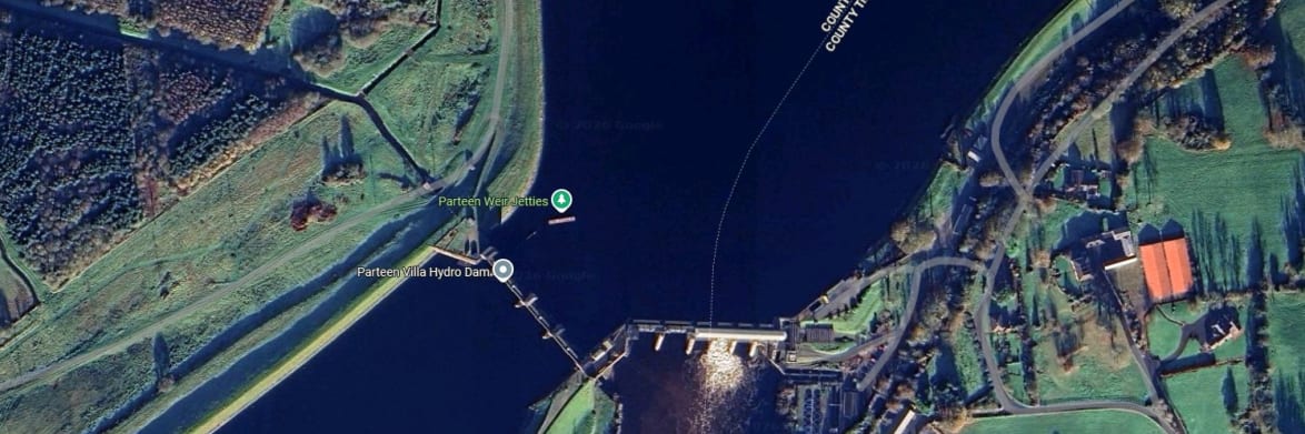
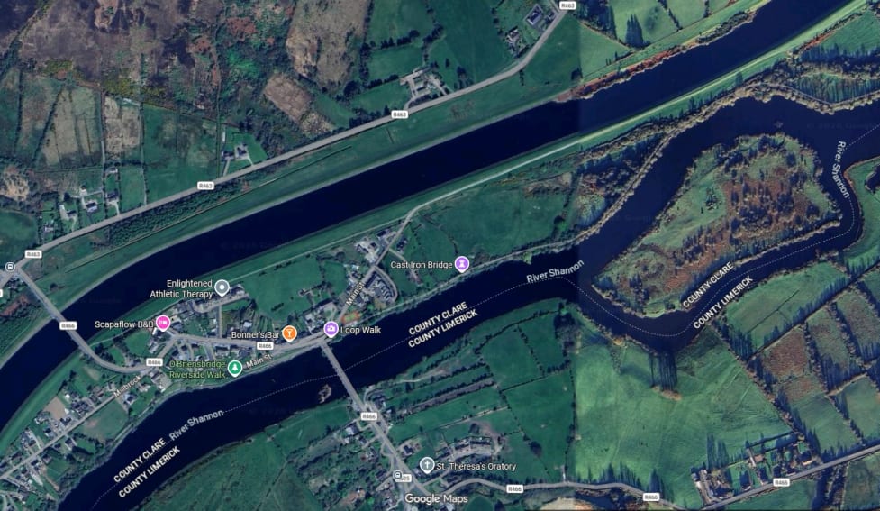
Parteen Weir is not widely known, but it is an essential piece of infrastructure tied to one of the most ambitious engineering projects undertaken by the Irish Free State in the 1920s. The Ardnacrusha hydroelectric dam was Ireland's first mega project, and it required a significant alteration to the River Shannon.
To create the necessary head of water for power generation, a new man-made canal - known as the head race - was constructed alongside the original river channel. The weir itself controls water flow into this canal, which then feeds the hydroelectric station at Ardnacrusha. As Bob Foley, founder of Engineers With Drones, explains: "The lower channel is the old Shannon, and the upper channel is the newly built - you can see it's very straight and very man-made looking. Very clean, very pretty."
The original Shannon River channel and the newly built man-made head race canal constructed for the Ardnacrusha hydroelectric scheme.
The challenge
Making sense of hydrological survey anomalies
The client had commissioned a detailed hydrological survey of the entire head race canal. The survey data revealed various anomalies throughout the canal bed - unexpected features that did not have an obvious explanation.
Some of these anomalies appeared as "a perfect line straight across the canal for no reason, half a meter deep or a meter deep," Bob recalls. Others showed up as groups of small depressions, or a wall structure near trees that the client could not account for. The survey data could identify that something was there, but it could not tell them what it was, what had caused it, or whether it posed any risk to the structure or operation of the canal.
That is where the ROV came in. The client needed visual evidence - high-resolution imagery of these anomalies to understand their nature, extent, and composition.
Method
How the inspection was carried out
The inspection was carried out in collaboration with the client, who provided access to a boat for the ROV operation. Engineers With Drones set up the ROV system on board and navigated to the predetermined GPS coordinates where the hydrological survey had identified anomalies.
At each location, the ROV was deployed into the water to capture high-resolution underwater imagery. The inspection covered two primary areas: all of the gates along the weir on the upriver side, and the anomalies distributed throughout the length of the head race canal.
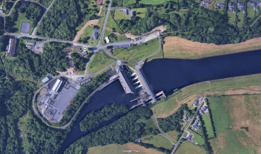
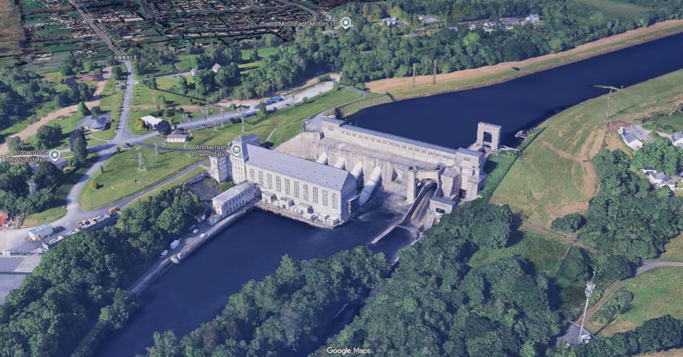
Ardnacrusha Power Station at the end of the head race canal, part of the historic hydroelectric scheme.
Findings
What the inspection found
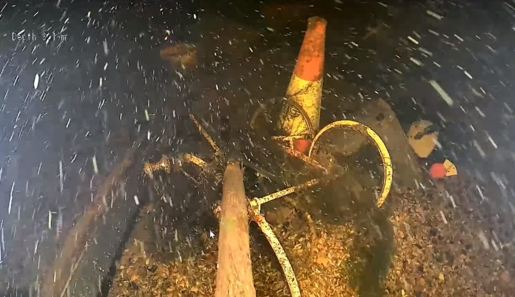
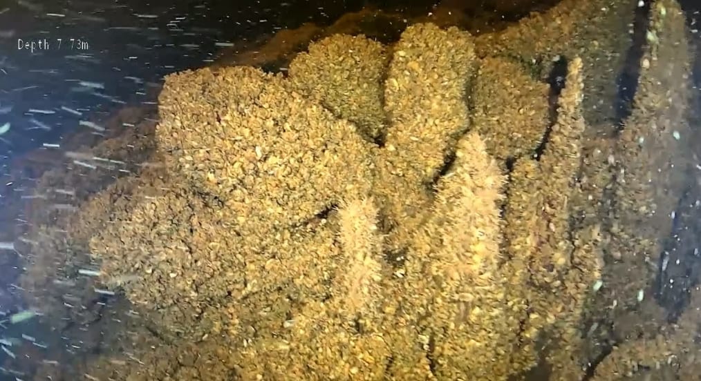
The ROV inspection provided clear visual evidence of what the hydrological survey anomalies actually were. In many cases, the features turned out to be depressions in the canal bed that had accumulated debris over decades.
Depressions with accumulated debris
One of the clearest indicators of a depression or defect in this type of environment is the accumulation of debris. The ROV imagery revealed a variety of objects that had settled into the low points over many years: an old pram, tires, barrels, buckets, the ubiquitous traffic cone, and a shopping trolley.
Accumulated debris including traffic cones and metal objects visible in a depression on the canal bed.
"We were able to look at the side of the depression there. So we were able to see exactly the extent of the depression and what constitutes it, possibly formed it and what is contained within the depression," Bob explains. The ROV could orbit around the edges of these features and then move in close to examine the interior detail.
Trenches with historic structural remnants
One of the more interesting findings was a trench feature that ran across the canal bed. Visible along the edge of the trench were the remains of old fence posts - retaining posts that have been in place since the canal was constructed.
"You can see the old fence posts - those retaining posts, they've been there for 100 years and there's still some evidence of them left," Bob points out. This is freshwater, which has preserved the posts to some extent, though they have deteriorated significantly over the century.
Trench feature visible across the canal bed with 100-year-old retaining posts still present.
"We were able to look at that going across the entire river - or the entire head race - and look at its composition, look at its size, look at what it was made up of, how it affected the flow, all that to see: is this something that the client should be concerned about going forward, or is this just an anomaly that looks unusual on your hydrographic survey but isn't something to be worried about?"
Technical capabilities - 4K imagery and laser scaling
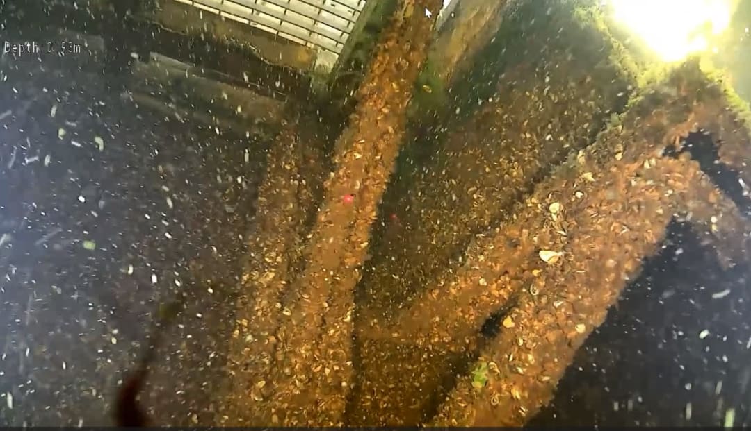
The ROV captured all underwater imagery in 4K resolution with onboard illumination, providing clear, detailed footage even in low-light freshwater conditions. A particularly useful feature for the inspection was the dual parallel laser scaling system mounted on the ROV.
The system projects two laser dots onto the surface being inspected, positioned exactly 10 centimeters apart. This provides an instant size reference for any feature visible on the screen - whether that is a crack, a hole, or spalling on a concrete surface. The client can immediately gauge dimensions: "OK, so that's about 20 centimeters long. That's about five centimeters long based on the two dots that appear on everything."
The dual parallel laser scaling system projects two dots exactly 10 centimeters apart, providing instant size reference for any defects or features on the inspected surface.
Real-time client guidance
Throughout the inspection, the client had their own monitoring screen showing the live ROV feed. This allowed them to guide the inspection in real-time - directing the operators to investigate particular features more closely, request different angles, or capture additional detail where something caught their attention. This collaborative approach ensures the client gets exactly the imagery they need while still in the field.
Underwater ROV footage from the head race canal inspection, showing the type of imagery the client was able to view and guide in real-time.
Assessment outcome
The visual inspection allowed the client to understand the nature of the features that had appeared as unexplained anomalies on the survey data. Importantly, no serious structural anomalies were found. The depressions and trenches turned out to be benign features - accumulated debris in low points and remnants of historic construction elements that posed no risk to the integrity or operation of the canal.
In each case, the ROV provided the context needed to determine whether a feature represented a structural concern or was simply an unusual but harmless characteristic of the canal bed. The client was satisfied that the anomalies identified by the hydrological survey had been visually assessed and posed no cause for concern.
The Ardnacrusha Power Station complex, fed by the head race canal inspected by ROV.
Outcome
Understanding what lies beneath
Hydrological survey data is extremely valuable, but it has inherent limitations. It can tell you that something is there, and it can give you precise measurements of depth and position. What it cannot do is tell you what that something actually is.
The ROV inspection bridged that gap. By providing high-resolution visual evidence at each anomaly location, the client was able to confirm that the features detected by the survey were benign - accumulated debris and historic construction remnants rather than active structural defects. What could have been a source of ongoing concern was resolved with certainty.
For infrastructure of this scale and age, that kind of informed decision-making is essential. The head race canal is a critical component of a hydroelectric system that has been operating for nearly a century. Understanding its current condition in detail allows the operators to maintain it safely and effectively for decades to come.
Let's talk
Speak to an engineer about your project
Complex surveys and inspections require more than just a pilot. Our engineers can help you scope your requirements and indentify the right approach.