A pier being inspected by a drone

Drone pier inspection When you have to inspect a coastal pier but you want to keep the costs down.

Overview

The Job at a Glance

A drone inspection of a 386-metre concrete pier and steel sheet pile wall, delivering full-coverage high-resolution imagery in under half a day — without boats or flat-calm sea conditions, working within a two-hour tidal window.

386-metre coastal pier

Concrete pier wall and hot-rolled interlocking steel sheet pile, inspected in full from the quayside without marine equipment.

Under half a day

Active data capture completed in under two hours within the tidal window, with all imagery verified before transfer.

DJI M300 RTK + Zenmuse H20T

Dual wide and zoom cameras delivering both orientation-level overview and hairline crack detail from a single flight.

Cloud-delivered condition data

Annotated imagery, defect classification, and structural findings uploaded to cloud for immediate client and stakeholder access.

Overview

Inspecting coastal infrastructure the efficient way

Concrete piers are critical components of waterfront structures. Over time, these piers can deteriorate due to exposure to harsh environmental conditions, leading to safety concerns and maintenance requirements. Traditional inspection methods are often time-consuming, costly, and may pose risks to personnel. In this case study, we will look at how Engineers with Drones used the latest in UAV technology for inspecting a concrete pier, showcasing their efficiency, safety, and accuracy in assessing the pier's structural integrity.

Comparative methodology

Why they chose us

For this 386-metre coastal pier inspection, a drone delivered full-coverage imagery in half a day — without boats, without flat-calm sea conditions, and without leaving the quayside.

Time in the field
Half a day vs 2+ days by boat

Data collection was completed in less than half a day, including both wide overview and close-up defect imagery.

Sea conditions needed
Any conditions vs flat calm only

The drone can operate effectively regardless of wave conditions, removing a key scheduling dependency.

Coverage achieved
All aspects vs partial boat access

Every surface of the pier — including faces inaccessible from a boat — was captured in high resolution.

Efficient option Our method

Using a drone

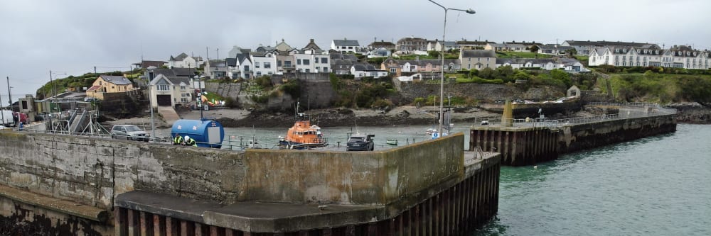
This is what the job looked like using drone technology.

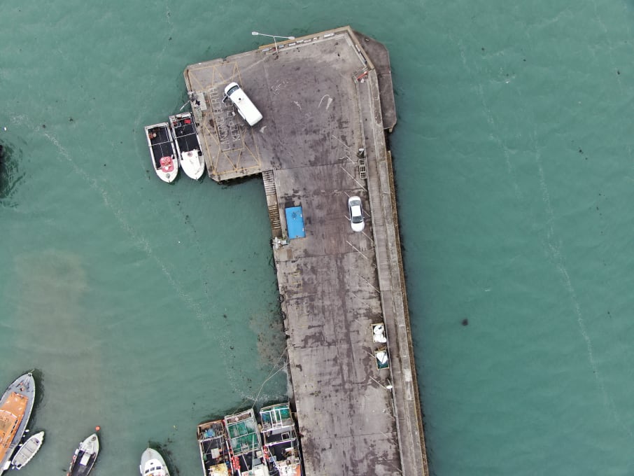
  • No boats required All data was captured from the quayside using the DJI M300 RTK, removing the need for any marine vessel.
  • Half a day of fieldwork Data collection was completed within the tidal window and verified on site before being transferred to the cloud.
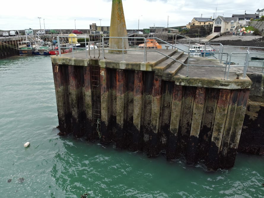
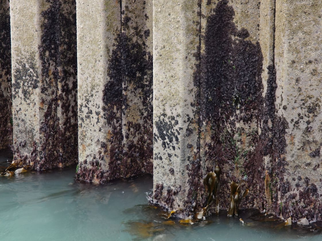
  • Inspection complete in 2 hours The entire 386 metres of pier wall and sheet piling was covered in under two hours of active data capture.
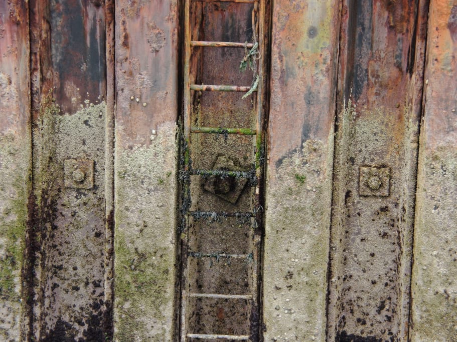
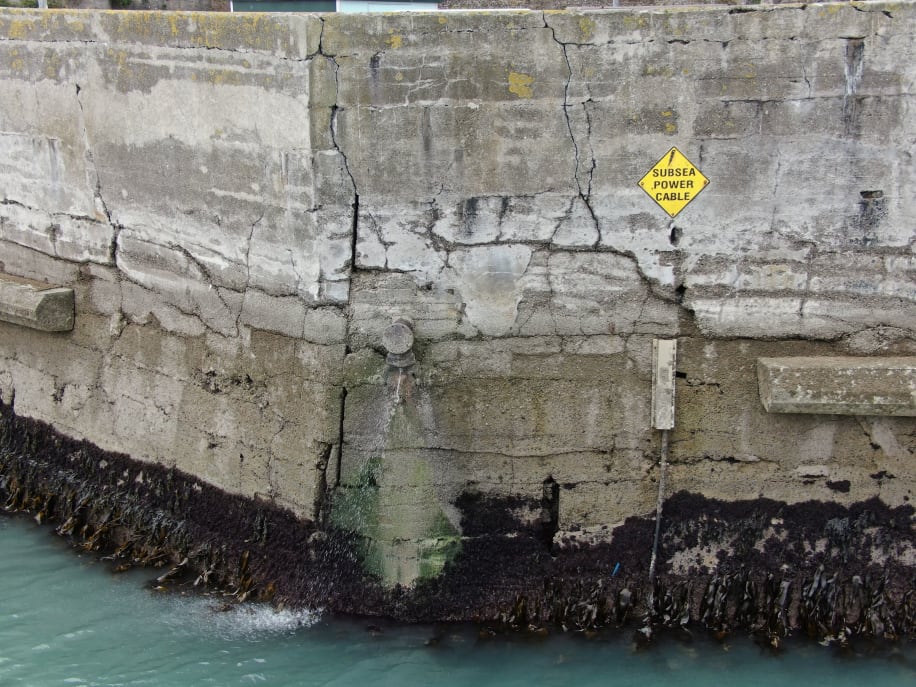
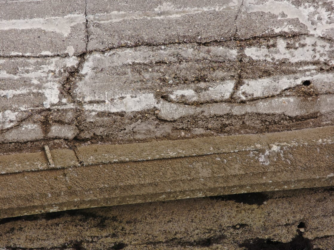
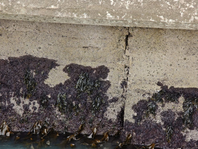
  • High-resolution images of all aspects The Zenmuse H20T wide and zoom cameras delivered both overview and close-up detail of every pier face.
  • Operational in any sea state Wave height and swell had no impact on the inspection, removing the weather dependency entirely.
Project status Complete and verified
Manned approach Traditional method

Without a drone

What the job would have looked like without drone technology.

  • Boat access required A vessel would need to work alongside the pier wall in open water, adding cost and operational complexity.
  • Not all aspects photographable Some faces of the pier structure could not be accessed or photographed from a boat in open water.
  • At least 2 days of fieldwork The same scope of coverage from a boat-based survey would require substantially more field time.
  • Flat calm seas required Boat access along the full pier wall would only be safe and practical in flat-calm sea conditions.
Operational impact Higher cost & weather dependent
Background

Pier Inspections

We were asked by a client to look at how we might bring value to a pier they were tasked with inspecting. The traditional method of conducting this inspection would be to send people out on boats assess to photograph the pier. They would slowly move along the length of the pier capturing data. We gave them a much more efficient option. Using a dedicated inspection drone were able to capture the entire pier in high-resolution for review back at the office. No expensive boat rental was required. The full pier was available to the team back in the office in stunning detail for a fraction of the price and time it would have taken using traditional methods.

Hot rolled interlocking steel sheet piles were a major feature to be inspected
Client requirements

High-res imagery of all features and defects

The client was a subcontractor for a local authority. They are an extremely well established firm in the marine and coastal space and were looking for a suitable partner to help with this project. They required broad overview imagery to see the big picture of the pier. They also needed detailed imagery of every feature and defect of the pier. They also need to be easily able to identify exactly where each defect was located on the pier.

Another key requirement of the client was that all deliverables and data was to be easily accessible by all stake holders.

Detailed imagery of items such as safety ladders and retaining bolts were important for the client.
Methodology

Planning and Drone Selection

For this inspection, a DJI Matrice M300 RTK drone was chosen due to its stability, high-resolution high-optical zoom camera capabilities, and Real-Time Kinematic (RTK) technology for accurate georeferencing. Detailed pre-flight planning was conducted, including airspace checks, weather assessment, and obtaining necessary permissions from local authorities. The drone was equipped with a high-resolution camera capable of capturing images and videos. A flight path was designed to cover the entire surface of the concrete pier, including its vertical sides and underside where applicable. Hot rolled interlocking steel sheet pile was a major feature to be inspected as was the 386 linear meters of concrete pier wall. Images were captured at predefined intervals and angles to ensure comprehensive coverage of the entire pier.

Overview imagery showing the extent of cracking and their positions on the pier wall surface was useful in determining the extent of the damage present.
In the field

Working with tidal swells and other coastal variables

By their nature coastal infrastructure inspections can be challenging. The environment can be tough but when you add in things like tides, swells and other variables its gets a lot worse. When you have the ability to negate all those variables while at the same time reducing the cost and then that's an opportunity you take.

Tide was a major consideration on the day. Choosing the right time to gather data while the water levels were lowest was important for getting as much data about the pier below the waterline as possible. We had a two hour tidal window in which to get all the data so we had to be efficient with our image capture plan.

By capturing data at low water we wer able to get a good idea of the condition of the structure below the water line.

We chose the DJI M300 RTK series inspection drone as the best option for this task. Coupled with the Zenmuse H20T payload with its dual wide and zoom camera s this aircraft was the perfect solution for an inspection like this. Using both the wide and optically zoomed cameras allowed us to see large sections of pier wall for orientation while also allowing us to zoom right into hairline cracks in the concrete.

Data collection itself was carried out in less than half a day. ALl the data was verified on site before being transferred to the cloud for backup. Back in the office the data was then sorted, filtered and categorised. We often say to clients that the field work is only half the job and that proper data management back in the office is a key element to a successful project. As soon as the data was processed it was uploaded to a cloud system that allowed the client and other stakeholders to access it as required.

Overview imagery of the whole pier in the form of video files was also provided to orientate the people back in the office.
Analysis

Comprehensive report and recommendations

Engineers and inspectors analysed the imagery for signs of damage, cracks, spalling, and other structural issues. From this analysis a comprehensive report was generated, including annotated images, and defect assessment and classification. The report highlighted critical areas requiring immediate attention and provided recommendations for maintenance and repair.

Detailed crack imagery was also captured so that an assessment could be made of the severity of the cracking.
Outcome

A safe, efficient and accurate assessment of critical infrastructure.

The use of drones for inspecting the concrete pier yielded several advantages:

Safety

Drone inspections eliminated the need for personnel to access potentially hazardous areas, reducing the risk of accidents.

Efficiency

The inspection process was completed in significantly less time compared to traditional methods, minimising disruption.

Accuracy

The high-resolution imagery allowed for precise defect identification and assessment of defects.

Cost-effectiveness

Drone inspections were more cost-effective than traditional methods, as they required fewer personnel and resources.

Data Accessibility

The digital nature of the data made it easy to archive and revisit for future comparisons and assessments.

The case study demonstrates the effectiveness of using drones for inspecting a concrete pier. Drones offer a safe, efficient, and accurate means of assessing the structural integrity of critical infrastructure components. By adopting drone technology for inspections, organisations can make informed maintenance and repair decisions, ensuring the long-term safety and functionality of their assets while reducing costs and minimising risks to personnel.

Being able to determine the difference cracking vs construction joints was an important factor in the inspection.
Let's talk

Speak to an engineer about your project

Complex surveys and inspections require more than just a pilot. Our engineers can help you scope your requirements and indentify the right approach.

Talk to an engineer

+353 (0)21 202 8281

Quickest for technical scoping

Email your brief

info@engineerswithdrones.ie

Best for sending detailed specs

Next steps

Where to find out more

You can find out more about our coastal infrastructure inspections or our drone surveying services. Alternatively, you can contact us here to ask what we can do for you.

Last Updated: