A photogrammetric survey with drone capture and high-resolution 3D modelling
Overview
The Job at a Glance
A photogrammetric survey of four historic stone causeways in west Galway, producing high-resolution 3D models, orthophotos, and CAD drawings to support structural assessment and repair planning.
West Galway
Four causeways in tidal areas, each 500-1000m long, serving as working roads and community lifelines.
1 day per causeway
Field capture including setup, risk assessments, chainage deployment, and drone operations. Processing took approximately 2 weeks.
2000-4000 images each
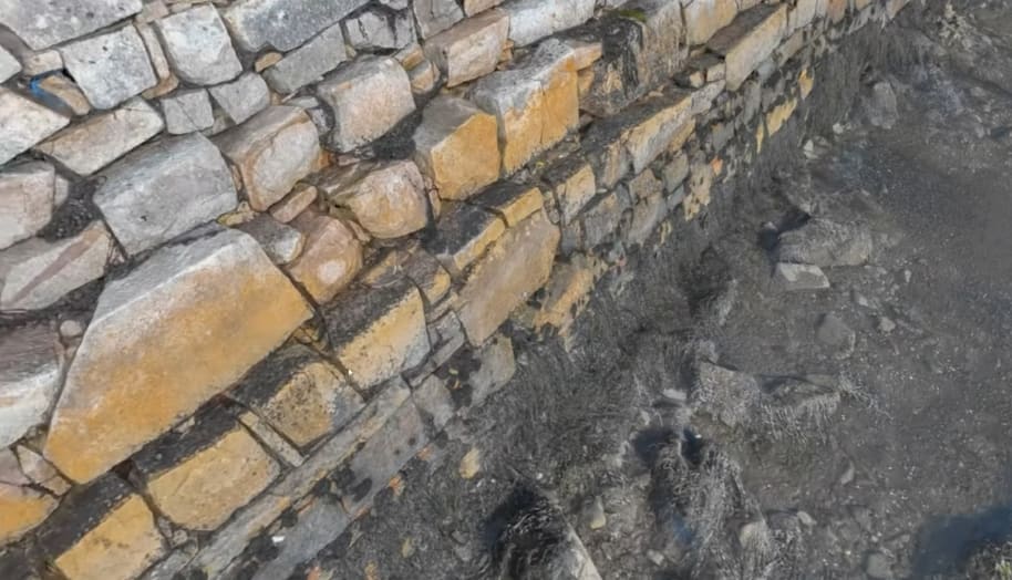
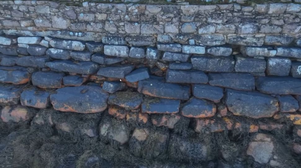
High-resolution photogrammetric capture processed into 3D models where individual cracks in the concrete are visible.
~80 pages printable
Complete deliverable package including 3D models, orthophotos, CAD drawings with chainages, and elevation drawings - all printable on A3 as requested by the client.
Overview
High-resolution 3D surveying of historic stone causeways
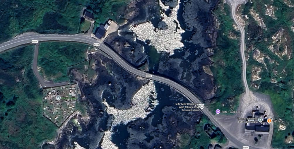
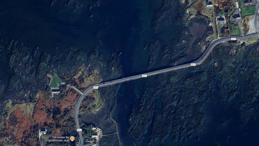
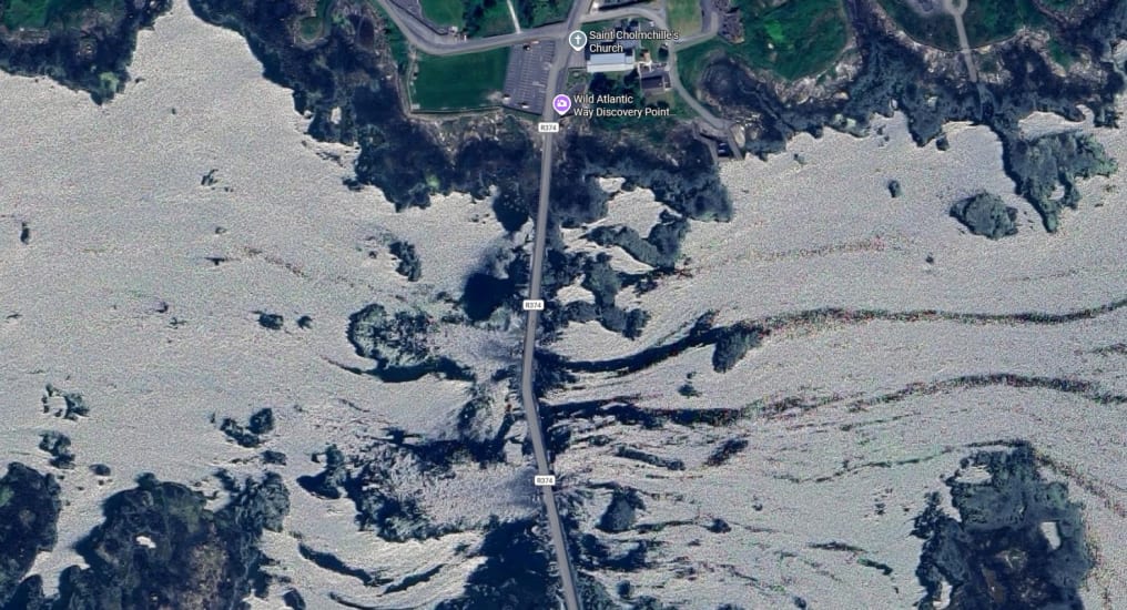
We were contacted by our client to verify the structural integrity of four very old and unique causeways in the west of Galway. These structures consist of historic dry-stone masonry; they are causeways composed of granite slabs that have been slotted together for structural stability. The client needed to assess them for damage, defects, and areas of concern. Each causeway is between 500 meters and a thousand meters long, and they're located in a tidal area where they're completely underwater at high tide and dry at low tide.
These causeways are working roads and lifelines for the communities in the area, keeping them connected. The challenge was to capture comprehensive survey data without disrupting traffic, while dealing with the tidal constraints and the need for baseline documentation to build a repair work pack.
Comparative methodology
Why they chose us
This project required full structural documentation of four historic tidal causeways while keeping working roads open. A drone-based photogrammetric approach delivered high-detail 3D and CAD outputs without the disruption associated with traditional surveying methods.
Coverage requirement
4 causeways500-1000m each
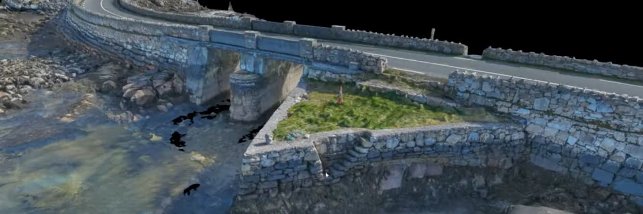
Each structure was surveyed end-to-end, including walls, steps, bridges, and the rock interface near the tidal zone.
Capture depth
2000-4000 imagesper causeway
Oblique photogrammetric capture complemented nadir views and improved structural visibility, including difficult vertical and underside areas.
Operational timing
1 day fieldworkper causeway
Field capture was coordinated with low-tide windows, with processing then completed over approximately two weeks.
Efficient optionOur method
Using a drone
This is what the job looked like using drone technology.
Comprehensive structural captureThe team captured full causeway geometry, not just road surfaces, including walls, steps, bridges, and edge interfaces.
Low-disruption operations on working roadsCapture was planned to avoid traffic disruption while still meeting the required survey scope.
Tidal-window executionData collection was aligned to low tide, when causeway structures were exposed and survey quality could be maximised.
High-detail digital outputsThe client received manipulable 3D models, orthophotos, CAD drawings with chainages, elevation and plan drawings, and A3-printable packs.
Project statusCaptured and delivered
Manned approachTraditional method
Without a drone
What the job would have looked like without drone technology.
More disruption to working roadsThe page notes traditional surveying methods would have been disruptive to these active causeway routes.
Harder tidal coordinationSurvey logistics are more difficult when timing and access must track changing water levels.
Slower route to full repair-pack documentationProducing complete structural outputs for all four causeways would be more time-consuming using traditional methods.
Operational impactGreater disruption & delays
The challenge
Comprehensive documentation without disruption
The causeways presented a unique surveying challenge. These historic structures link lands together across tidal waters, serving as essential infrastructure for local communities. Traditional surveying methods would have been time-consuming, disruptive to the working road, and difficult to coordinate with tidal conditions.
The causeways link lands together across tidal waters in west Galway, serving as essential infrastructure for local communities.
The client needed detailed, accurate data that would allow them to identify problem areas - missing rocks, holes in walls, areas of structural concern - and build a comprehensive repair work pack. This meant capturing not just the road surface, but the full three-dimensional structure including walls, steps, bridges, and the base layer of rock where it interacts with the water.
The causeways traverse tidal areas where water levels change dramatically between high and low tide.
Timing was critical. The structures are "completely encased in water on all sides" when the tide is in, but "pretty much dry" when the tide goes out. This tidal window dictated the entire capture strategy.
At low tide, the full extent of the causeway structure becomes visible, providing the optimal conditions for photogrammetric capture.
Video footage
3D model walkthrough
See the high-resolution 3D model in action, showing how this deliverable allows our client to virtually inspect the causeway structure from their office.
Capture method
Photogrammetric survey - the oblique capture advantage
This job was done using photogrammetric drones with high-resolution photogrammetric cameras - cameras that are specifically designed for capturing survey-level data with features that make them much better at it. But the technology is only half the story.
The key differentiator is the capture method. Instead of pure nadir imagery - straight down from a bird's eye view - the focus was on oblique capture. "It's not all captured from the bird's eye view where you would miss a lot of the underneath data," Bob notes. This approach meant that even the underneath of bridges was captured, which is "something that's rare in terms of quality photogrammetric data."
Each causeway required between 2000 and 4000 images to achieve this level of detail. The oblique approach also had a practical advantage: it allowed the drone to stay away from the working road.
Survey setup
Ground control and chainages
Before any drone operations began, ground control was deployed across each causeway. This established the accurate positional foundation for all the survey data. But there was another critical element: chainages.
The client provided drawings, and the team marked chainages all the way along each causeway. These are distance markers - reference points that allow any location along a 500m to 1000m structure to be precisely identified. "Anywhere at all, if a client finds a defect that they want to report on, they can see exactly where it is relative to the closest chainage mark." Bob explains.
This becomes especially important on longer structures. "Not so important on a short one like that, but when it's a kilometer long or maybe more, it's important to have that sort of information in." Once field teams go out with wellies and cameras to verify repairs, the chainages allow them to "find that exact same location easily."
The chainages were also marked into all the orthophotos and CAD drawings, creating a seamless link between the digital deliverables and physical reality. It's the difference between a pretty picture and technically usable survey data.
In 10 years' time for example, a fresh inspection can be compared against what we captured. They'll know exactly what it looked like when the repairs were completed - and they'll be able to see straight away if there's been any deterioration since.
Bob FoleyEngineers With Drones
In the field
Field work and data capture
Capturing data on working roads in a tidal environment required careful planning and execution. The entire operation had to be coordinated around low tide. "Capturing it at low tide was very important. That way we get a lot more detail," Bob explains. Water distorts photogrammetric data, so timing the capture when the causeways were fully exposed was essential.
The causeways are working roads carrying traffic. Oblique capture methods allowed drone operations without disrupting vehicles.
Safety and awareness were paramount. "Keeping the drone in visual line of sight was very important," Bob notes. The structures were broken down into sections so that direct line of sight could always be maintained, with various operating locations established. Obstacles like telephone poles - "which has been clipped off" in the imagery but are "much higher than that" in reality - required constant monitoring.
The client also had specific coverage requirements beyond just the causeway structure itself. "The client also had a requirement to capture data, five meters out all the way along on either side of the causeway," Bob explains. This extended coverage area needed its own orthophotos, which meant capturing the data "nearly straight on, which got much better data" rather than relying on sideways views from nadir imagery.
GDPR compliance and public access
Because these are working roads with public access, GDPR compliance was built into the workflow. All raw data was anonymised using tools within the processing software before being presented to the client. "There's not a single identifiable personal element in there," Bob confirms - no faces, no number plates, nothing that could identify individuals.
On site, if people or groups were moving slowly through the capture area, operations were simply paused. "We just stop operations so that they can move through without being captured, without being interfered with. And once they're moved through, then we'll resume operations again."
This approach also solved the vehicle problem. While cars might appear in individual images, when processing thousands of images into a 3D product, "that car will be in maybe three photographs, but it won't be in the couple of hundred photographs that represent this particular area." The processing naturally filters out transient objects through statistical averaging.
Outputs
Processing and deliverables
Field capture might take a day per causeway, but the processing is where the heavy lifting happens. "You're talking more like two weeks" to transform the raw imagery into the full suite of deliverables, Bob notes. "The processing is a much bigger and much more complex job."
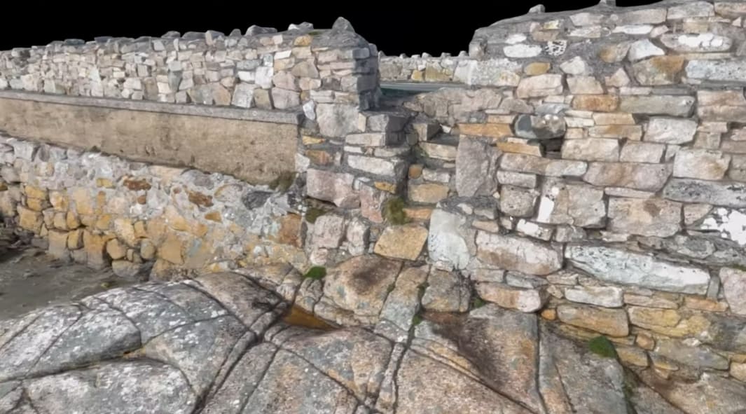
The 3D models allow clients to inspect structures from the office, manipulating the view to examine details like this bridge and wall intersection.
The workflow progresses through several stages: first generating the photogrammetric point cloud, then the 3D model, then all the orthophotos - both the nadir (top-down) views and the 90-degree side views of the walls. "And then also the other ones, which would be the inside of these walls as well," Bob adds.
Next came the CAD drawings overlaying the orthophotos, showing all the chainages and measurements "so that they could be reconciled with the real world." Elevation drawings and plan drawings of the entire causeway structure completed the technical package.
Problem areas like missing stones and structural gaps are clearly visible in the 3D models, allowing the client to build repair work packs.
Deliverables for the client
The client received a comprehensive technical package for each causeway:
High-resolution 3D models
Manipulable models where individual cracks are visible, allowing virtual site visits and structural assessment from the office.
Orthophotos (nadir)
Vertical top-down corrected imagery of the entire causeway structure.
Orthophotos (90-degree)
Side-view orthophotos of walls and vertical surfaces, including inside wall faces.
CAD drawings with chainages
Technical drawings overlaying orthophotos with all chainages marked for field reconciliation.
Elevation drawings
Side-view technical drawings of the causeway profiles.
Plan drawings
Top-down technical drawings showing the complete structure and all chainages.
A3 printable outputs
All deliverables formatted for printing on A3 paper as requested by the client.
Let's talk
Speak to an engineer about your project
Complex surveys and inspections require more than just a pilot. Our engineers can help you scope your requirements and indentify the right approach.