When a building is too dangerous to enter, confined space drones go first
Overview
The Job at a Glance
A comprehensive drone survey of a derelict hospital building in Wexford using external 3D photogrammetric scanning and internal confined space drone technology. The survey documented the building condition and extent for restoration feasibility assessment without requiring any personnel entry.
Wexford
Historic hospital building, surrounded by fence, dense vegetation overgrowth, unsafe to enter due to collapsing structure.
Two drone systems
External photogrammetric drone for 3D scanning plus internal confined space drone for interior documentation.
Complete documentation
3D photogrammetric model accessible via internet link, plus 4K video footage at 30fps of internal structure.
Zero entry required
No personnel exposed to collapsing structure during entire survey operation.
Comparative methodology
Why they chose us
The building was inaccessible from ground level and too dangerous to enter. Drone technology provided the only safe way to understand its full extent, internal condition, and restoration potential.
Access achieved
Full 3D + videovs road view only
External photogrammetric scan and internal 4K video gave the client a complete picture of the building in a single day.
Safety risk
Zero exposurevs collapsing roof entry
No personnel entered the building at any point. All assessment was carried out remotely.
Discovery
Hidden courtyard foundvs unknown from outside
The drone revealed hidden internal features including a courtyard and the full building extent — invisible from the road.
Efficient optionOur method
Using a drone
This is what the task looked like using drone technology.
External 3D scan of entire structureA photogrammetric scan captured the full external extent of the building, including areas hidden by dense vegetation.
Internal 4K video surveyA confined space drone was flown through the building interior without any personnel entering the structure.
Zero personnel exposureNo one entered the collapsing building at any point during the assessment.
Single link for entire project teamAll imagery was uploaded to the cloud, giving the full team access to building condition without site visits.
Hidden features identifiedThe inspection revealed a courtyard and the full building layout that could not be seen from ground level.
Heritage documentation capturedThe building's condition was documented in detail before any remediation or demolition work begins.
Immediate feasibility decisionThe client could make a fully informed restoration feasibility decision based on actual condition data.
Client outcomeFeasibility decision made immediately
Manned approachTraditional method
Without a drone
What the task would have looked like without drone technology.
View from road onlyDense vegetation and a fence made the building invisible and inaccessible from ground level.
No internal assessment without entryUnderstanding the internal structure would have required sending personnel into a building with actively collapsing roofs.
No drawings availableAs a historic building with no available plans, there was no way to understand the layout without physical access.
Falling roof and beam hazardTiles and structural timbers were actively falling inside the building, presenting an extreme hazard to any entrant.
No safe approach pointsWithout a drone to scout first, it was not possible to establish where personnel could safely enter.
Multiple dangerous site visits neededThe project team could not be orientated to the building's condition without repeated hazardous visits.
Risk levelExtreme — entry not recommended
The challenge
Understanding what you're dealing with when you can't safely look
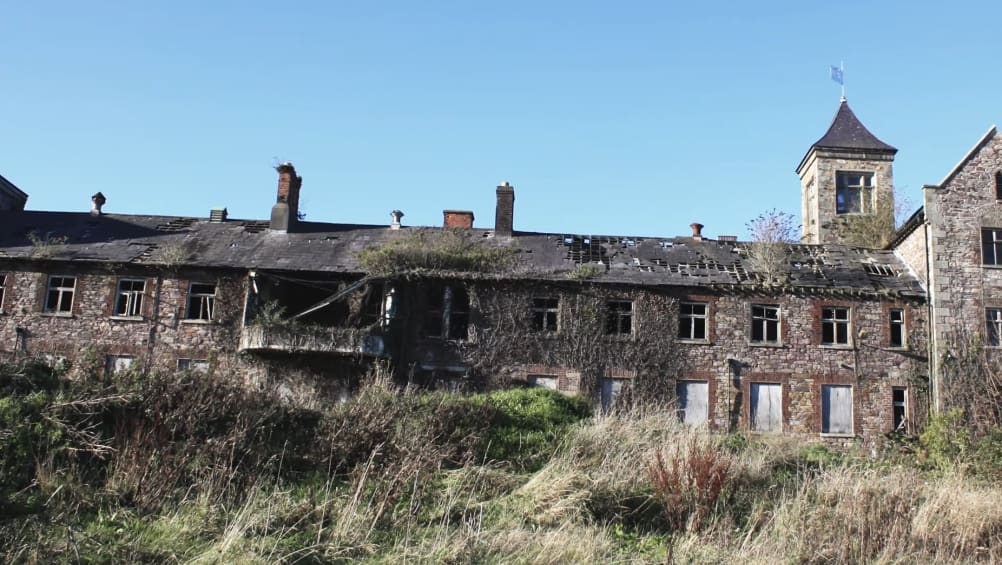
An established client approached Engineers With Drones to assess the feasibility of restoring a historic hospital building in Wexford. This would have been the main hospital building, but it has since been overtaken by a new hospital building and left to ruin.
But it is a very beautiful building. It could still become a functional building again, and the client needed to understand its current condition and restoration potential.
The problem: "it's incredibly dangerous to go inside because it's collapsing" - all the roofs are collapsing. The walls are beautiful old stone walls, but the roof is just falling in.
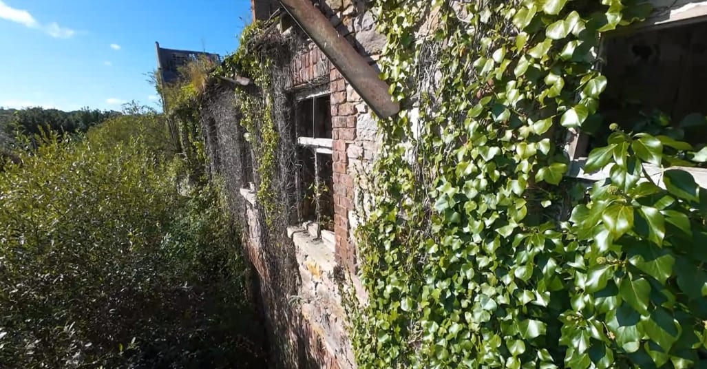
The beautiful old stone walls are still standing, but the building is surrounded by a fence with dense vegetation making it impossible to see the full extent from ground level.
The client needed to know what they were dealing with at a fundamental level. "Is there still walls inside? Is there a roof inside? What is the story with this building?" All anyone could see was dense bush and a building behind it, with a fence preventing access to even understand the extent or layout of the building.
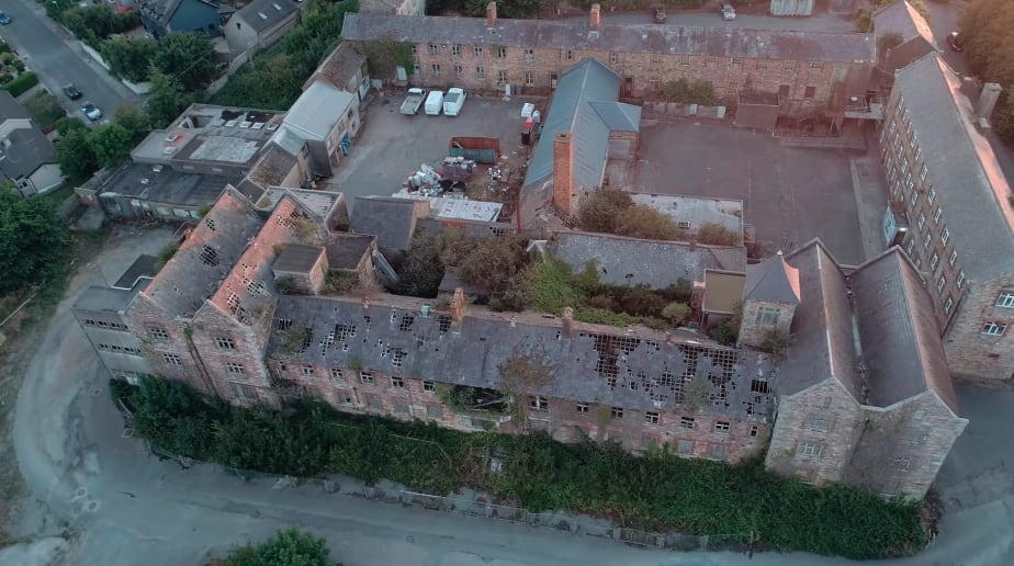
Drone footage reveals the dense bush and overgrowth that prevents ground-level understanding of the building's layout and extent.
There were no drawings for a building like this - it was built years and years and years ago. The building was completely inaccessible for conventional assessment.
So the client asked Engineers With Drones to provide a solution.
Approach
The two-technology approach
To give the client a complete understanding of what exactly they were dealing with, Engineers With Drones deployed two different drone technologies: an external photogrammetric drone and an internal confined space drone.
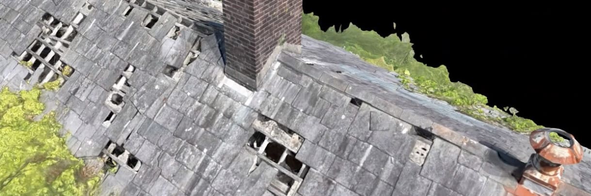
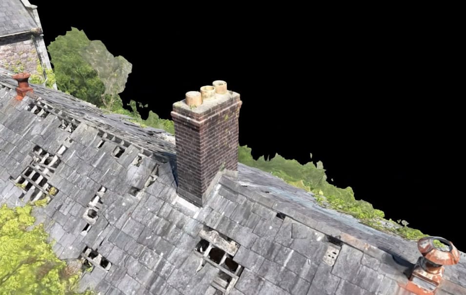
The external photogrammetric drone created a full 3D scan of the entire structure from the outside. This allowed the client to understand the overall condition, the extent of the building, features like chimneys and roof condition, and areas that weren't even visible from ground level.
The internal confined space drone went inside through open windows and documented the interior spaces with high-quality 4K video. This showed what the inside looked like - the condition of floors, ceilings, beams, walls, and crucially, where it was safe to approach and where it was not.
Together, these two approaches gave the client everything they needed to assess the feasibility of the restoration project and make informed decisions about how to proceed.
3D scan
External 3D photogrammetric scan - seeing what nobody else can see
One of the best solutions Engineers With Drones could provide was a full photogrammetric 3D scan of the entire structure. "That way anybody associated with the project at all with a single internet link could suddenly get extremely well orientated with exactly what they were dealing with."
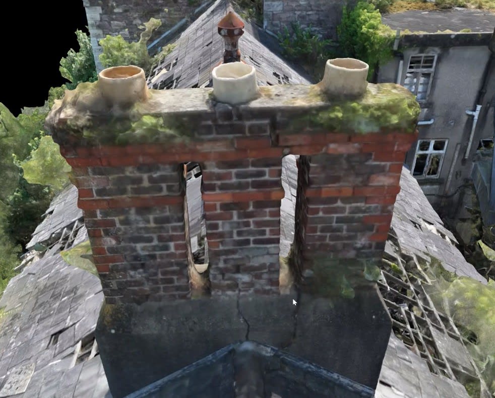
The photogrammetric scan is quite lifelike and quite useful. You can clearly see the condition of the roof slates and tiles. You can see the condition of the brickwork in chimneys - whether there are major cracks or not.
Drone footage clearly shows where the roof is collapsing in, and not in good condition at all.
"An awful lot of things can be understood at an intuitive level very very fast by anybody looking at this 3D model." Whereas most people who would approach this building without the 3D model would only see it from the road, with the model they can see everything.
The 3D photogrammetric model shows chimney condition in detail - one chimney shows no major cracks, while another has significant cracking running down through it.
Video: Interactive 3D model
See the 3D photogrammetric model in action. The video shows how users can zoom in and out, rotate the view, and examine any part of the building from their office:
Interactive 3D photogrammetric model showing how users can zoom in and out, rotate views, and examine any part of the building structure remotely.
Discovering what wasn't visible from the ground
The 3D model revealed features the client had no idea existed. "They had no idea that there was some form of courtyard here" where all these trees are growing. All the gaps, the tall chimney - everything becomes clear in the model.
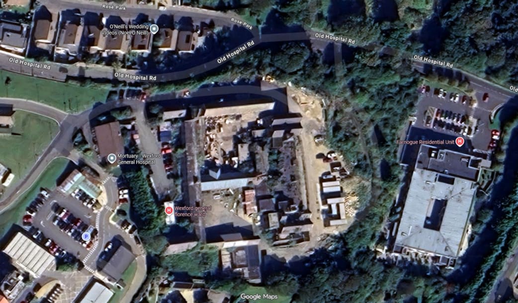
This is what most people would see from publicly available maps - but it gives no understanding of the building's actual condition or interior layout.The aerial survey revealed the full extent of the building including a courtyard that the client had no idea existed until the photogrammetric scan revealed it.
Understanding the limitations and strengths of photogrammetry
The photogrammetric process is not good at processing thin objects like fences, wires, or tree branches. "But monolithic objects like buildings, it's extremely good at processing" - which is why the boarded up sections almost look exactly like a photograph. It's very easy to understand and intuitive. You can get an idea of size, scale, shape, and condition very quickly.
A permanent heritage record
At some point somebody in the demolition business will come in and strip out all these roofs. "But they will have a record of what it was" - they'll know there was a little bell tower where a bell could go, chimneys, air vents. "So there is a record of how they found it before they broke it all down and rebuilt it."
Internal survey
Internal confined space drone survey - walking through without walking through
Once the external scan was complete, Engineers With Drones "fired up our internal confined space drone" to show the client what the inside looks like.
The video quality is extremely high - shot in 4K at 30 frames per second "so that the client could pause it at any point" and examine details.
How the confined space drone accesses the building
"Any open, clean access at all is usable." The drone starts broadly to orientate viewers to the location - accessing about halfway down the building, first floor. "You never want to start just right in the thing because then nobody knows where you are."
Open windows and broken glass provide access points for the confined space drone without requiring any forced entry or structural modification.
Then the drone carefully accesses the window, looking up and down to make sure everything is checked and visible. There's a nice big open span that the drone can easily fly through.
What the video reveals
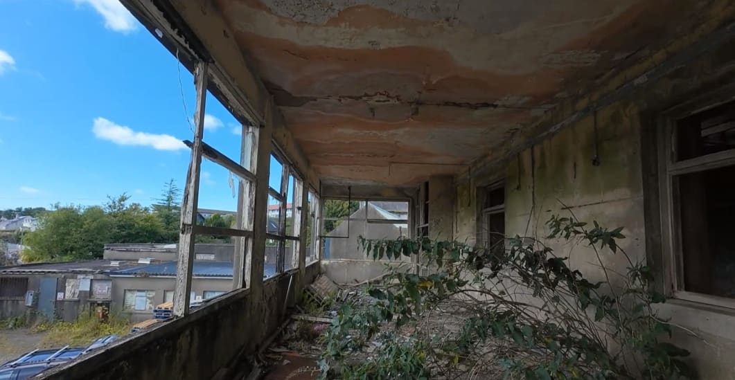
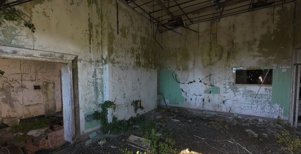
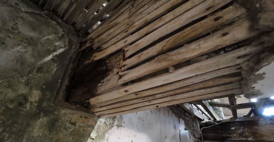
Once inside, "you get an idea. We're fundamentally inside an old ward or something like that. You can see the old tiles that used to be on the wall there. That sort of 70s green." Old shelving, old corridors, door frames, old stud partitions - all clearly visible.
Confined space drone footage reveals the interior structure - old ward layouts, 70s tiles, corridors, and door frames all clearly visible.
All of this is extremely useful for the client in terms of deciding how best to approach the project. You can see where the floor is completely collapsed, the roof above almost completely gone. "Remember if you were walking through here normally any of those tiles could come down at any moment on top of your head."
"Whereas the drone here if a tile comes down, yeah the drone might get hit but that's all we got to worry about, nothing else."
The drone flies at almost head height, "just walk through the building, step through various doors, windows, whatnot" and gives a very good impression of exactly what the structure looks like.
Video: Confined space drone footage
Watch the confined space drone navigate through the interior of the derelict building, capturing 4K footage at head height as it moves through wards, corridors, and around structural elements:
Confined space drone footage captured at 4K resolution, flying at head height through wards, corridors, and documenting internal structural condition.
Findings
What the survey revealed - understanding condition and safe approach
The purpose of this survey was not to create a defect classification report, but to give the client an understanding of what they were dealing with so they could assess feasibility and plan a safe approach. Here's what the survey documented.
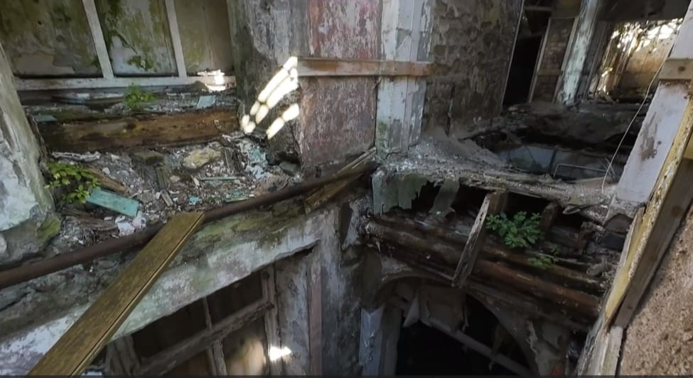
Complete floor collapse in multiple areas
In several areas, "the floor is completely gone, all the joists are completely gone." But anybody can look at this and understand the condition of the building.
Drone footage shows the floor is completely collapsed, the roof above it almost completely gone, and all the joists completely gone.
Staircase in good condition - a safe approach point
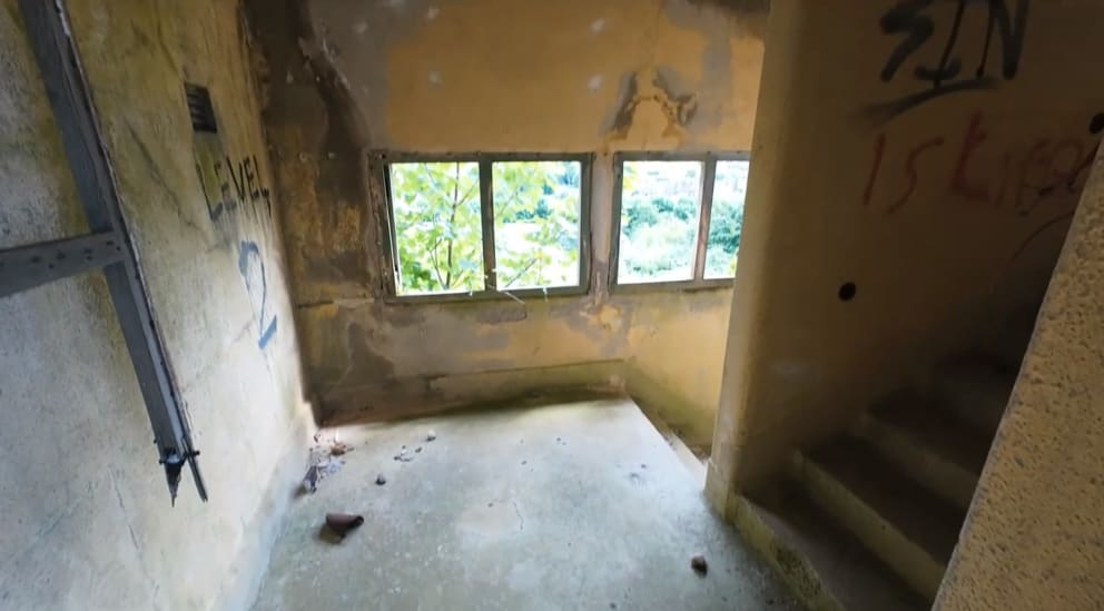
One of the most useful findings was identifying safe access points. An old staircase was found to be in reasonably good condition. "There's no debris. There's no overgrowth. There's no falling object dangers." The team could at least get up the staircase to make further analysis. "That'd be a good point of approach."
Drone footage shows the staircase is in reasonably good condition with no debris, no overgrowth, and no falling object dangers - making it a good point of approach.
Unstable upper floors with hanging materials
In contrast, a first or second floor area was identified where "that floor there looks incredibly unstable and the roof above it and the materials above it hanging down look incredibly unstable." This told the client where not to approach.
Drone footage reveals this floor looks incredibly unstable and the roof above it and the materials hanging down look incredibly unstable.
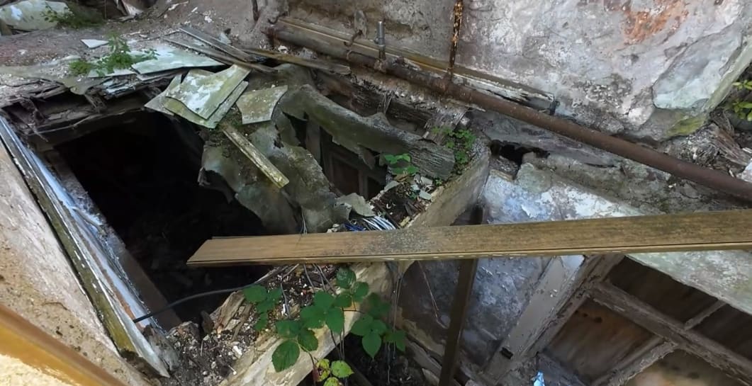
Critical beam assessment - water damage and rot
The drone paid particular attention to the heavy duty beams "because those will tell the client overall whether it's safe to access or whether they have to attack the problem from a different angle."
One wooden beam was found to have significant issues: "that beam is not in good conditions. Rotten could be dangerous. The plaster could be dangerous. There's a lot of water damage on the end of that wooden beam."
Drone footage captures beam condition in detail - this beam is not in good condition, rotten and dangerous with a lot of water damage on the end of the wooden beam.
Steel work condition visible throughout
Throughout the survey, the condition of the steel work was documented and captured in the imagery "so that the client can then make a much more detailed assessment of how they want to access this building and where the danger points are."
Heritage
Conservation context - what stays, what goes
An important consideration for this project was heritage protection. Not all of the building has the same status.
"All of the stonework is fully conserved. You wouldn't be allowed to touch that." The beautiful old stone walls that form the core structure of the hospital are protected and must be preserved.
But sections that were built later don't have that protection. Newer sections built in 1960 have no heritage value - "we'll just knock all that right now because it's easier to knock it and build something else there than to try and renovate that."
The client could make decisions like that based on the imagery at the very start "as opposed to waiting and then looking and going actually this is not worth it." They could immediately see what needed to be preserved and what could be replaced.
Deliverables
Everything needed for feasibility assessment
Engineers With Drones presented "a whole set of video deliverables and a whole set of 3D photogrammetric data to the client. And that was what they wanted. That was their scope."
Full 3D photogrammetric model
Accessible via single internet link for entire project team orientation
General aerial imagery
External views showing overall building condition and context
4K confined space video footage
Shot at 30fps, pausable at any point for detailed examination
Complete documentation of extent and layout
Including courtyard discovery and full building footprint
Safe approach point identification
Showing where teams can safely access versus dangerous areas
Outcome
Informed decisions without dangerous site visits
Once the client had the deliverables, "they seemed very happy. They were able to make an awful lot of decisions based on the imagery in those videos."
Feasibility assessment without personnel risk
The entire feasibility assessment could be conducted without requiring anyone to enter the dangerous structure. The project team was able to understand what they were dealing with - the extent of the building, which areas were collapsed, which areas were stable, where heritage stonework existed, where 1960s additions could be demolished and replaced.
Team orientation from a single link
Anybody associated with the project could access the 3D model through a single internet link and immediately understand the building. There was no need to bring multiple team members out to the dangerous site for orientation. They could access the model remotely and fully understand what they were looking at.
Restoration timeline and planning
The building itself is significant. As Bob Foley notes: "I don't see anybody tearing it down anytime soon. I see it more as a building that will be restored in time."
The survey data will support that restoration project by providing complete baseline documentation, safe approach planning, and a permanent record of the building's condition before work begins.
Let's talk
Speak to an engineer about your project
Complex surveys and inspections require more than just a pilot. Our engineers can help you scope your requirements and indentify the right approach.