When GPS fails under concrete, drone inspection deliverables give you the data you need.
Overview
The Job at a Glance
A detailed drone inspection of pier infrastructure at Belview Port, using video instead of stills to overcome GPS failure under the concrete structure. The inspection documented concrete defects, spalling, and structural condition across the entire underside of the port platform.
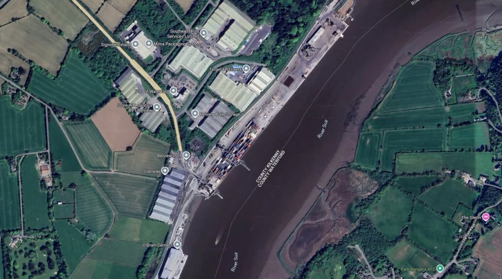
Belview Port, Waterford
Shore-side pier structure on driven piles, requiring coordination with port authorities and shipping schedule.
Tidal window constraint
All fieldwork completed within the tidal window to ensure adequate flight area under the structure.
4K 30 FPS video dataset
Complete video documentation with all flights recorded east-to-west for consistent orientation throughout the dataset.
Full RAMS and port liaison
Complete Risk Assessment and Method Statement prepared and agreed with port health and safety officer before fieldwork.
Comparative methodology
Why they chose us
For this inspection of Belview Port pier, a drone delivered safer access, better imagery, and a completed survey within the tidal window — without any boat or personnel working under the structure.
Time on site
Half a dayvs multi-day boat survey
All data was captured and verified on site within the tidal window, without any need for repeated visits.
Safety risk
Zero riskvs boat access under structure
No personnel needed to work from a boat in tidal conditions beneath a loaded pier structure.
Data quality
4K videovs distance photography
High-resolution 4K footage of the entire underside, including close-up detail of every defect and repair.
Efficient optionOur method
Using a drone
This is what the job looked like using drone technology.
No boats requiredThe entire inspection was completed from the quayside without any need for a marine vessel.
Completed within tidal windowAll data was captured and verified on site within the available low-water window.
4K video of entire structureThe full underside of the pier was documented in high-resolution 4K video, including areas where GPS failed beneath the concrete.
Close-up defect detailEvery crack, spall, and repair was captured in close-up regardless of GPS signal loss under the concrete structure.
No disruption to port operationsThe inspection was coordinated around shipping movements with no operational shutdown required.
No work at height or over water All personnel remained safely on the quayside throughout the entire inspection.
Project statusComplete and verified
Manned approachTraditional method
Without a drone
What the job would have looked like without drone technology.
Boat access under structureA vessel would need to manoeuvre beneath the pier in potentially dangerous tidal conditions.
Dangerous tidal conditionsChoppy water and tidal currents create a hazardous working environment for boat-based access.
Poor imagery from distanceA camera operated from a moving boat cannot achieve the close-range resolution needed for defect classification.
Weather-dependent schedulingFlat-calm conditions would be required, making scheduling unpredictable and the job time-consuming.
Risk to personnel from boatsWorking from a boat under a loaded pier structure carries both water hazard and falling object risk.
Extensive safety proceduresBoat access under a live port structure would demand extensive risk assessment, permits, and safety equipment.
Operational impactHigher cost and greater risk
The challenge
Drone inspection of pier infrastructure at Belview Port
An engineering company needed a detailed assessment of concrete defects on the underside of Belview Port's pier structure - but traditional boat-based inspection methods were dangerous, time-consuming, and couldn't produce the quality of imagery required for proper defect classification. With giant cranes running on tracks causing structural stress, and the entire platform supported by piles driven into the seabed, the client needed high-resolution documentation of the concrete condition without putting personnel at risk. Engineers With Drones were called in to carry out the inspection using UAV technology - but the concrete overhead presented a challenge: GPS signals failed, making standard georeferenced stills impossible. The solution was drone-based video inspection.
Findings
What the inspection found
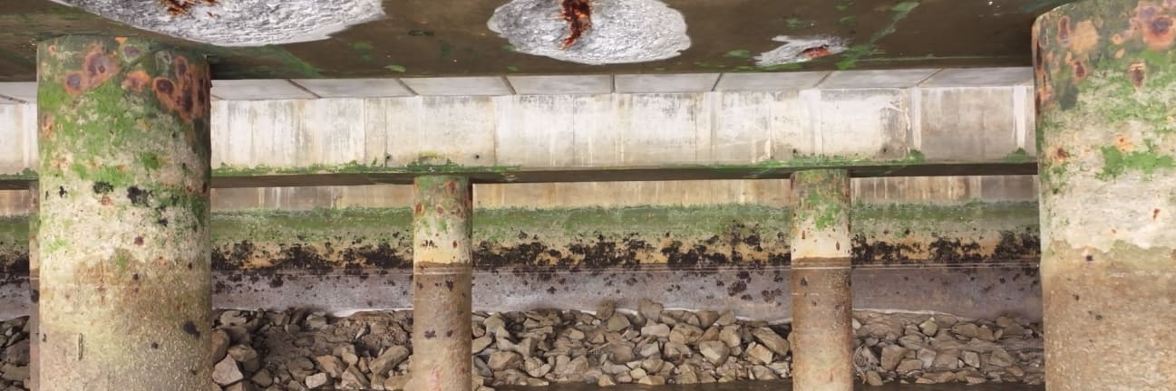
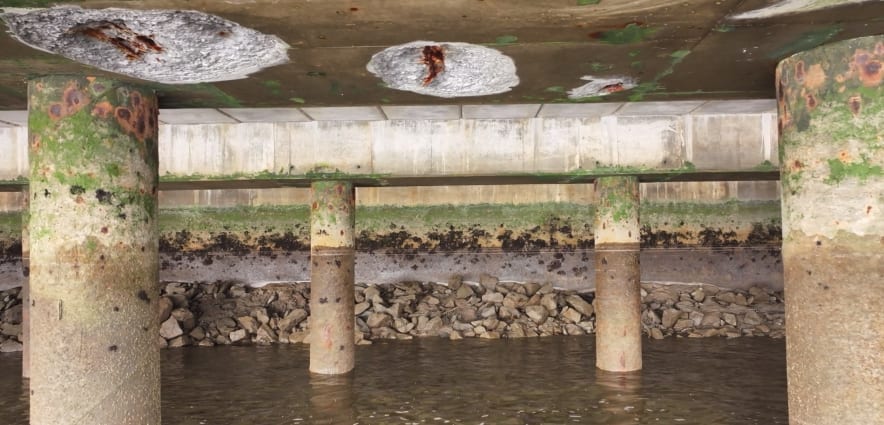
The drone inspection provided comprehensive documentation of the concrete condition across the entire underside of the pier structure. The scale of the operation is impressive - a single shipping container on a truck gives a sense of how massive the entire infrastructure is.
The pier structure extends a considerable distance from the shoreline, with supporting piles visible beneath the concrete platform where all port operations occur.
Concrete defects and spalling
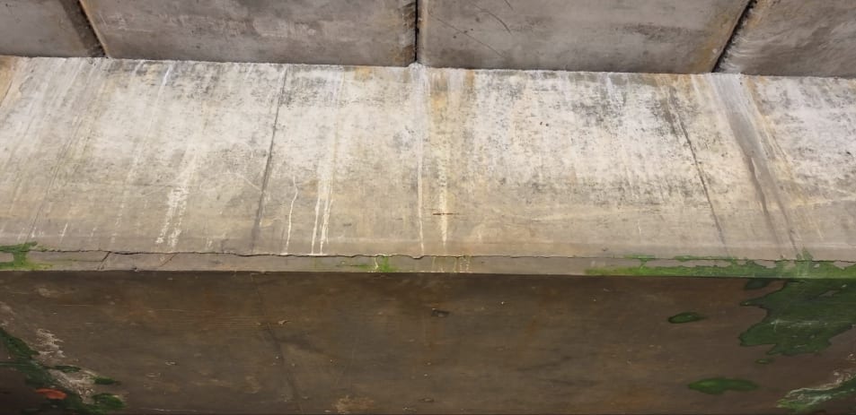
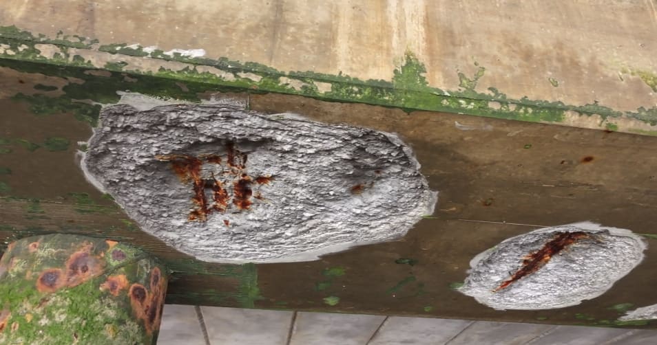
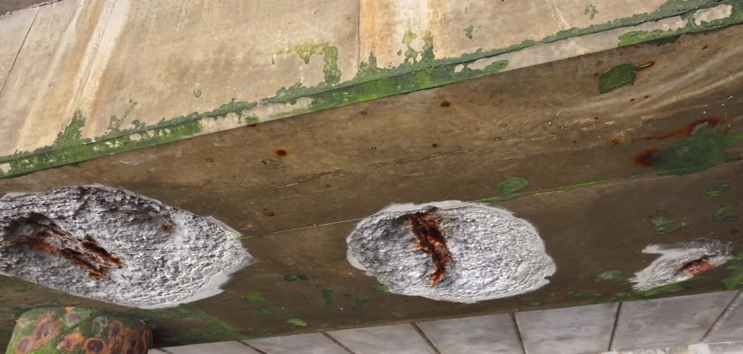
The inspection revealed multiple areas where the concrete had spalled away, exposing the steel reinforcement underneath. These defects were clearly visible in the high-resolution video, allowing the client to assess the extent of deterioration and plan appropriate remedial measures.
you can see clear defects already in the concrete where it has come away and you can see the steel reinforcing underneath
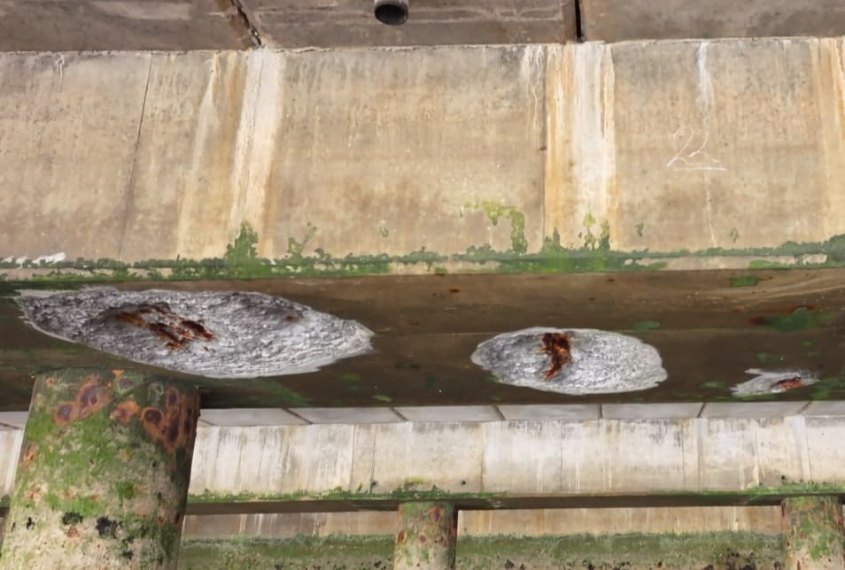
Previously repaired sections
When we encountered previously repaired sections of concrete, we made sure to capture the repair identification numbers. This allowed the client to reference their maintenance records and compare the current condition to the state of the structure when repairs were last conducted, helping assess whether degradation was continuing or repairs were holding.
Planning
Coordination and preparation
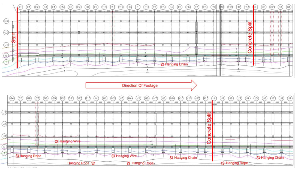
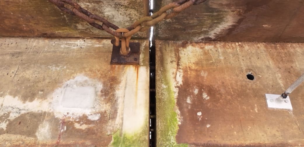
The first step in any complex inspection is thorough planning and coordination. The client provided detailed drawings of the entire shorefront structure, showing the waterline and stations where each set of piles is driven. There are four piles extending outwards along the entire structure. These drawings proved invaluable for orientation and documentation purposes.
We annotated these drawings with various defects found during the inspection, as well as obstacles and observable orientation marks that were visible both on top and underneath the structure. Features such as split lines in the concrete were marked, as these could be seen from both above and below.
As Bob Foley, founder of Engineers With Drones, put it: "There is nothing worse than getting a thousand images and not knowing where any of them actually is. What you always want is imagery plus orientation so that you know exactly what you're looking at and where you're seeing that thing."
Scale and overview
The scale of the port infrastructure is substantial. Aerial overview imagery provided critical context for understanding the full extent of the inspection area and helped orient detailed defect footage within the larger structure.
Aerial overview imagery provided critical context for understanding the full extent of the inspection area and the scale of port operations.
Orientation marks
Features such as split lines in the concrete were particularly valuable as orientation marks because they could be identified from both above and below the structure. This allowed us to cross-reference the underside defect imagery with topside location references.
Split lines in the concrete were particularly valuable as orientation marks because they could be identified from both above and below the structure.
There's no world where you're going in under port infrastructure without having full liaison with port authorities and making sure that they are fully in the loop. We had extensive discussions with the port's health and safety officer, going through exactly how we would execute the inspection. We generated comprehensive risk assessments and method statements, which we presented to the port authorities. They reviewed these documents and requested some minor changes to align with their specific regulations. We discussed emergency procedures and contingency plans in detail.
Timing was critical for this project. We had to coordinate with tidal schedules - there's no point in doing it if there's very high tide and you've got a very low flight area. This timing constraint required careful planning and efficient execution to complete all data capture within the tidal window.
We also had to coordinate with the port's shipping schedule. The drone would be happy out with a ship there but there'd be very low light and then your imagery wouldn't be great. By scheduling our inspection during gaps in the shipping schedule when there was no ship in front of the port, we ensured that natural light could reach the target area, resulting in high-quality imagery, so that the client can make really good decisions based on that imagery.
Execution
Drone Inspection Execution
Lighting management
One of the most significant technical challenges we faced was lighting management. Even though there was plenty of ambient light in the area, the quality of imagery depends heavily on proper camera orientation relative to the light source. When the camera was oriented properly with the gimbal pointed up at the concrete, we could capture excellent detail of the concrete structure.
Repair defects were clearly visible in the high-resolution video, showing areas where previous remedial work had been carried out.
However, if we turned the camera around with light coming from outside directly into the lens, it significantly reduced image quality due to backlight. To counter this, we had to carefully manage gimbal positioning to ensure that only the detail we were looking to capture appeared in the imagery, avoiding situations where the camera was pointed toward the bright exterior opening.
Proper lighting technique allowed the team to capture excellent detail of the concrete surface despite challenging conditions.
Flight consistency and orientation
Another critical decision we made was regarding flight consistency. As Bob Foley explains: "You see every single video was recorded from east to west. It took us longer in the field to do that because we'd have to fly back and then do another bit and fly back and do another bit. But it means that when you're looking at all of the imagery, you know for sure you're going from here and you're going in that direction." This approach is crucial for maintaining orientation throughout the dataset and making the entire collection more usable for engineering review.
Client-provided drawings showed the waterline, stations, and pile positions, which were annotated with defects and orientation marks during the inspection.
Video vs still imagery - why video won
An important consideration for this project was the choice between video and still imagery. The client intentionally wanted video and not stills. The reason for that was because it was such a large site and everything was so uniform. Any one image was just too difficult to lock down to a location. Georeferencing wasn't possible on this one because the concrete overhead was messing with the GPS signal.
So it wouldn't be as accurate as it needed for georeferencing. The best course of action was to just use video. The client agreed it was a good idea, and we proceeded to capture all data in 4K resolution at 30 frames per second.
Defect documentation
We captured detailed imagery of all visible defects, ensuring we zoomed in on areas of concern. The repair identification numbers on previously repaired sections were clearly captured, allowing the client to track degradation over time. Being able to see both the big picture and zoom into specific defects is essential for comprehensive structural assessment.
Post-processing
Data Processing and Delivery
Once we completed field operations within our tidal window, we brought all the data back to the office for processing. Proper data management and organisation is critical to delivering value to clients and ensuring inspection findings are accessible and actionable. Once we generated all that imagery, we then brought it all back to the office, renamed everything, collated everything, deleted what was not required, generated drawings, and made all of our orientation videos.
The complete video dataset with orientation information integrated throughout allowed the engineering team to assess the structure comprehensively.
We renamed all files according to a clear, logical naming convention that indicated location and content. We collated the footage into organised folders by section and inspection area. Any footage that didn't meet quality standards or wasn't required for the final deliverable was deleted to avoid cluttering the dataset. We generated annotated drawings showing where each video segment was captured and what features or defects were visible in each segment.
Once all data processing was complete, we sent everything to the client for verification. The client reviewed the dataset, confirmed they could locate specific features and defects, and verified that the level of detail met their requirements. Once they confirmed satisfaction with the deliverables, we considered the project complete.
Outcome
A comprehensive video dataset
The client received a comprehensive dataset of 4K 30 FPS video covering the entire underside of the port infrastructure. With proper orientation information integrated throughout the dataset, their engineering team could make broad assessments of the whole structure and generate detailed reports on specific defect locations, severity levels, and recommended remedial actions.
The inspection was completed with no disruption to port operations. All flights were conducted within the tidal window and coordinated with the shipping schedule to ensure natural light access. Personnel remained safely away from the structure throughout the inspection.
The project demonstrated the effectiveness of video-based drone inspection when GPS georeferencing is not possible. By standardising flight direction (east-to-west), creating self-documenting orientation videos, and delivering a dataset that could be navigated independently, we provided the client with exactly what they needed to make informed decisions about this critical port infrastructure.
Let's talk
Speak to an engineer about your project
Complex surveys and inspections require more than just a pilot. Our engineers can help you scope your requirements and indentify the right approach.